IMAGES TAKEN NEAR TO
Late Broads, BRADFORD-ON-AVON, BA15 2NW
Introduction
This page details the photographs taken nearby to Late Broads, BA15 2NW by members of the Geograph project.
The Geograph project started in 2005 with the aim of publishing, organising and preserving representative images for every square kilometre of Great Britain, Ireland and the Isle of Man.

There are currently over 7.5m images from over14,400 individuals and you can help contribute to the project by visiting https://www.geograph.org.uk
Image Map
Images are licensed for reuse under creativecommons.org/licenses/by-sa/2.0
Notes
- Clicking on the map will re-center to the selected point.
- The higher the marker number, the further away the image location is from the centre of the postcode.
Image Listing (43 Images Found)
Images are licensed for reuse under creativecommons.org/licenses/by-sa/2.0
Image
Details
Distance
1
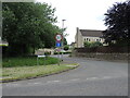
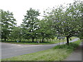
Late Broads
Winsley has expanded greatly in the latter part of the twentieth century, with this junction leading to the intriguingly-named Late Broads.
Image: © Neil Owen
Taken: 21 May 2024
0.06 miles
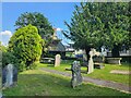
2
Alley behind the church, Winsley
This is wide enough to once have been (as the Italians say) 'passo carrabile' but has been blocked with some bollards. Another change is the wooden fences behind the original stone wall. Winsley abounds in little alleys like this.
Image: © HelenK
Taken: 12 Jul 2017
0.07 miles
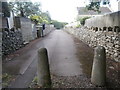
4
The Conkwell turnoff
The B3108 meets the Conkwell road: a sign advertises a wood-fired sauna, curiously.
Image: © Neil Owen
Taken: 21 May 2024
0.08 miles
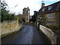
5
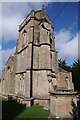
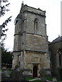
The tower of Winsley church
The tower of St Nicholas church in Winsley.
Image: © Philip Halling
Taken: 14 Sep 2018
0.09 miles
6
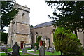
St Nicholas' church, Winsley
The tower was part of an earlier church, and is connected by a raised and covered passageway. For more details see http://www.wshc.eu/blog/item/the-churches-that-left-their-towers-behind.html?category_id=10
Image: © David Martin
Taken: 2 Sep 2018
0.09 miles
7

Tower of St Nicholas' church, Winsley
The tower was part of an earlier church, and is connected by a raised and covered passageway, seen here. For more details see http://www.wshc.eu/blog/item/the-churches-that-left-their-towers-behind.html?category_id=10
Image: © David Martin
Taken: 2 Sep 2018
0.09 miles
8
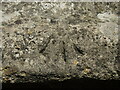
Pivot on St Nicholas's church, Winsley
A fairly uncommon benchmark on the older tower of the village church. The tower is a remnant of the original building, but the mark is from the nineteenth century. See https://www.bench-marks.org.uk/bm170739 for the entry in the Benchmark Database.
Image: © Neil Owen
Taken: 21 May 2024
0.09 miles
9
St Nicholas church Winsley
The detached tower of Winsley church.
Image: © Dave Kelly
Taken: 28 Feb 2012
0.09 miles