IMAGES TAKEN NEAR TO
Bath Road, BRADFORD-ON-AVON, BA15 1SS
Introduction
This page details the photographs taken nearby to Bath Road, BA15 1SS by members of the Geograph project.
The Geograph project started in 2005 with the aim of publishing, organising and preserving representative images for every square kilometre of Great Britain, Ireland and the Isle of Man.

There are currently over 7.5m images from over14,400 individuals and you can help contribute to the project by visiting https://www.geograph.org.uk
Image Map
Images are licensed for reuse under creativecommons.org/licenses/by-sa/2.0
Notes
- Clicking on the map will re-center to the selected point.
- The higher the marker number, the further away the image location is from the centre of the postcode.
Image Listing (8 Images Found)
Images are licensed for reuse under creativecommons.org/licenses/by-sa/2.0
Image
Details
Distance
1
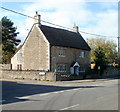
Corner of Bath Road and Ashley Road, Bradford-on-Avon
There is postbox embedded in the wall on the right side of the cottage.
Image: © Jaggery
Taken: 7 Oct 2011
0.11 miles
2
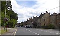
Houses by the Bath Road, A363, Bradford-on-Avon
Image: © David Smith
Taken: 7 Jun 2017
0.13 miles
3
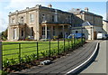
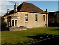
Grade II listed Berryfield House, Bradford-on-Avon
Berryfield (or Bearfield) House was built in the early 19th century. It was the residence of various grandees until the 1930s. It had been empty for some time when it was requisitioned by Wiltshire County Council in August 1939 for use as a maternity hospital, in readiness for the arrival of evacuees and their mothers. In 1979 it became Bradford-on-Avon Hospital. After the hospital closed in 2006 the site was developed for housing. The main house was converted for domestic use and houses built in the grounds.
Berryfield House was Grade II listed in August 1974.
Image: © Jaggery
Taken: 7 Oct 2011
0.14 miles
4
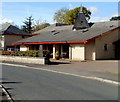
Cedar Court, Bradford-on-Avon
The West Wiltshire Housing Society building in Berryfield Road contains 28 flats.
Image: © Jaggery
Taken: 7 Oct 2011
0.18 miles
5
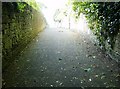
Descent towards Bradford-on-Avon
As Bradford-on-Avon has grown up it has gradually enclosed but still maintained a footpath from the north. Here it is now an alley between high stone walls as it starts the steep descent towards the town
Image: © Graham Horn
Taken: 2 May 2007
0.21 miles
6
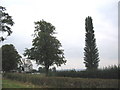
Telecom tree
The observant will notice that the symmetrical tree at the right of the photo is actually a telecom mast, carrying mobile phone antennae and microwave dishes. Both it and the new access road to the livery stables (indicated by the white sign) are recent additions to the B3105 which is behind the hedge in the foreground.
Image: © Phil Williams
Taken: 13 Sep 2005
0.21 miles
7
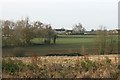
2007 : Rough ground, Maplecroft
Looking across fallow land, Upper Bearfield Farm is directly ahead with Winsley further on the right.
Image: © Maurice Pullin
Taken: 25 Nov 2007
0.23 miles
8
Grade II listed Bearfield Church, Bradford-on-Avon
Viewed from Huntingdon Street. The late 18th century building was Grade II listed in August 1974. Bearfield Church has had several earlier names, including Bethel Chapel, the Countess of Huntingdon’s Chapel and Bearfield Congregational Church.
Image: © Jaggery
Taken: 7 Oct 2011
0.25 miles