IMAGES TAKEN NEAR TO
Broadmoor Lane, BATH, BA1 4LL
Introduction
This page details the photographs taken nearby to Broadmoor Lane, BA1 4LL by members of the Geograph project.
The Geograph project started in 2005 with the aim of publishing, organising and preserving representative images for every square kilometre of Great Britain, Ireland and the Isle of Man.

There are currently over 7.5m images from over14,400 individuals and you can help contribute to the project by visiting https://www.geograph.org.uk
Image Map
Images are licensed for reuse under creativecommons.org/licenses/by-sa/2.0
Notes
- Clicking on the map will re-center to the selected point.
- The higher the marker number, the further away the image location is from the centre of the postcode.
Image Listing (2 Images Found)
Images are licensed for reuse under creativecommons.org/licenses/by-sa/2.0
Image
Details
Distance
1
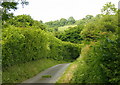
2008 : Blind lane near Upper Weston, Bath
Aldermead and Foxhall Farm are at the end of the lane. The higher slopes of Lansdown can be seen, with the racecourse a short way over the top of the hill.
Image: © Maurice Pullin
Taken: 5 Jun 2008
0.15 miles
2

Higher than Upper Weston
Walkers on the steep path up from Bath to the lofty heights of Bath racecourse.
Image: © Neil Owen
Taken: 2 May 2020
0.21 miles