IMAGES TAKEN NEAR TO
Vernslade, BATH, BA1 4DN
Introduction
This page details the photographs taken nearby to Vernslade, BA1 4DN by members of the Geograph project.
The Geograph project started in 2005 with the aim of publishing, organising and preserving representative images for every square kilometre of Great Britain, Ireland and the Isle of Man.

There are currently over 7.5m images from over14,400 individuals and you can help contribute to the project by visiting https://www.geograph.org.uk
Image Map
Images are licensed for reuse under creativecommons.org/licenses/by-sa/2.0
Notes
- Clicking on the map will re-center to the selected point.
- The higher the marker number, the further away the image location is from the centre of the postcode.
Image Listing (12 Images Found)
Images are licensed for reuse under creativecommons.org/licenses/by-sa/2.0
Image
Details
Distance
1
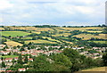
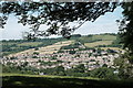
2008 : North east from Dean Hill
Looking over Upper Weston to Lansdown and Beckford's Tower. Image
Image: © Maurice Pullin
Taken: 28 Jul 2008
0.05 miles
2
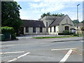
Weston Free Church
One of 30 Moravian congregations in the UK
Image: © Eirian Evans
Taken: 30 May 2019
0.06 miles
3
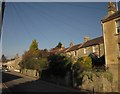
High Street, Weston
From the same spot as Image, looking up the street towards the roundabout where it ends, with a row of cottages set back behind gardens and described at http://www.britishlistedbuildings.co.uk/en-446015-99-102-bath .
Image: © Derek Harper
Taken: 11 Feb 2012
0.10 miles
4
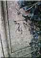
Ordnance Survey Cut Mark
This OS cut mark can be found on the gatepost to the NE of Deanhill Lane. It marks a point 66.660m above mean sea level.
Image: © Adrian Dust
Taken: 14 Sep 2016
0.11 miles
5

Terrace, High Street, Weston
Part of a listed terrace http://www.britishlistedbuildings.co.uk/en-446016-103-107-bath near the western end of the High Street.
Image: © Derek Harper
Taken: 11 Feb 2012
0.12 miles
6

Listed buildings, High Street, Weston
Looking to the right of the view in Image, with the listed terrace http://www.britishlistedbuildings.co.uk/en-446016-103-107-bath , and a C17 gabled cottage at the end http://www.britishlistedbuildings.co.uk/en-442690-108-bath . Beyond is a side road leading to Brookfield Park.
Image: © Derek Harper
Taken: 11 Feb 2012
0.13 miles
7
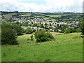
Weston from Penn Hill
Photography is a useful hobby when engaged on a long distance walk you're not really fit enough to undertake as it enables you to stop for a rest under the pretence of taking photographs. That's how this view of Weston came to be taken.
Image: © John Winder
Taken: 19 Jun 2017
0.14 miles
8

Shops in Weston
A row of shops on High Street in Weston in the suburbs of Bath.
Image: © Philip Halling
Taken: 17 May 2021
0.21 miles
9
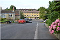
Harcourt Gardens, Weston, Bath
Looking down to the High Street.
Image: © Julian P Guffogg
Taken: 31 Jul 2014
0.21 miles
10
View over Upper Weston
View over Upper Weston from the Cotswold Way.
Image: © Philip Halling
Taken: 12 Jul 2021
0.21 miles