IMAGES TAKEN NEAR TO
The Down, TROWBRIDGE, BA14 8QW
Introduction
This page details the photographs taken nearby to The Down, BA14 8QW by members of the Geograph project.
The Geograph project started in 2005 with the aim of publishing, organising and preserving representative images for every square kilometre of Great Britain, Ireland and the Isle of Man.

There are currently over 7.5m images from over14,400 individuals and you can help contribute to the project by visiting https://www.geograph.org.uk
Image Map
Images are licensed for reuse under creativecommons.org/licenses/by-sa/2.0
Notes
- Clicking on the map will re-center to the selected point.
- The higher the marker number, the further away the image location is from the centre of the postcode.
Image Listing (46 Images Found)
Images are licensed for reuse under creativecommons.org/licenses/by-sa/2.0
Image
Details
Distance
1
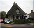
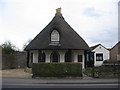
Old Toll House by the B3106, Trowbridge
Down (Islington) Toll House by the B3106, in parish of Trowbridge (West Wiltshire District), The Old Toll House, No. 41, Islington, BA14.
Grade II listed.
List Entry Number: 1021618 https://historicengland.org.uk/listing/the-list/list-entry/1021618
Surveyed
Milestone Society National ID: WI.TRO
Image: © Alan Rosevear
Taken: 13 Oct 2007
0.05 miles
2
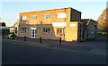
Nutz4Bikes, Trowbridge
Located on Canal Road, Trowbridge. The shop Nutz4Bikes was originally opened as a retail outlet for stainless steel nuts and bolts made by G.M. Stevens & Co. Their business has now expanded to include motorbike accessories, parts and clothing.
Image: © Jaggery
Taken: 5 Dec 2011
0.07 miles
3
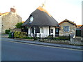
Grade II listed The Old Toll House, Trowbridge
The mushroom-shaped building at 41 Islington is the last thatched building remaining in Trowbridge.
It is opposite the Grade II listed Palmers Almshouses. http://www.geograph.org.uk/photo/2759949
It was built as a turnpike cottage. The British Listed Buildings website states "early 19th century". Another source makes a case for "probably 1768", the year in which the Trowbridge Turnpike Act of 1751-2 was renewed and the road from Trowbridge to Hilperton Marsh was turnpiked. This meant that wheeled vehicles and people with animals were charged for using the road, and houses needed to be built to collecting the turnpike tolls.
The building has been a private residence since the closure of the turnpike in 1870. It was Grade II listed in December 1950.
Image: © Jaggery
Taken: 5 Dec 2011
0.08 miles
4

Plaque on the Almshouses
A close view of the plaque on the Almshouses at Islington.
Image: © Phil Williams
Taken: 17 Mar 2006
0.08 miles
5
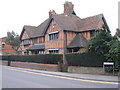
The Almshouses, Islington
A view looking to the west across Islington towards the Almshouses.
Image: © Phil Williams
Taken: 17 Mar 2006
0.08 miles
6

The Almshouses , Islington
A view looking to the north across Islington towards the Almshouses.
Image: © Phil Williams
Taken: 17 Mar 2006
0.08 miles
7

Islington Toll
A view looking northeast across the B3106 to the Islington Tollhouse.
Image: © Phil Williams
Taken: 2 Mar 2006
0.08 miles
8
Islington Toll
A view looking east across the B3106 to the thatched Toll House at Islington.
Image: © Phil Williams
Taken: 2 Mar 2006
0.08 miles
9

Toll house at Islington
A view looking southeast across the B3106 Islington to the thatched toll house.
Image: © Phil Williams
Taken: 2 Mar 2006
0.08 miles
10
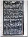
The tariff at Islington Toll
A detail view of the board in the porch of Islington toll house giving the tariff for various items. Note the sum of one penny to take your ass along the road!
Image: © Phil Williams
Taken: 2 Mar 2006
0.08 miles