
IMAGES TAKEN NEAR TO
James Street, TROWBRIDGE, BA14 8NJ
Introduction
This page details the photographs taken nearby to James Street, BA14 8NJ by members of the Geograph project.
The Geograph project started in 2005 with the aim of publishing, organising and preserving representative images for every square kilometre of Great Britain, Ireland and the Isle of Man.

There are currently over 7.5m images from over14,400 individuals and you can help contribute to the project by visiting https://www.geograph.org.uk
Image Map
Images are licensed for reuse under creativecommons.org/licenses/by-sa/2.0
Notes
- Clicking on the map will re-center to the selected point.
- The higher the marker number, the further away the image location is from the centre of the postcode.
Image Listing (51 Images Found)
Images are licensed for reuse under creativecommons.org/licenses/by-sa/2.0
Image
Details
Distance
1

Trowbridge Unitarian Meeting House
A notice board outside the bungalow at 45 Seymour Road, Trowbridge shows that this is a Unitarian Meeting House. Unitarians welcome all who believe that religion is wider than any sect and deeper than any set of opinions. Trowbridge Unitarians trace their origins back to a group of dissenters known to have met secretly near Southwick in about 1655. At that time, before the Act of Toleration (1689), it was dangerous for Dissenters to meet, so the members had to meet outside Trowbridge. The congregation has met in this bungalow since the 1980s, following the demolition of Conigre Unitarian Church.
Image: © Jaggery
Taken: 5 Dec 2011
0.03 miles
2
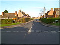
Queens Road, Trowbridge
Viewed across Melton Road.
Image: © Jaggery
Taken: 5 Dec 2011
0.04 miles
3

Seymour Road houses near the corner of Palmer Road, Trowbridge
Image: © Jaggery
Taken: 5 Dec 2011
0.05 miles
4

Avonvale Road houses, Trowbridge
Viewed from the Seymour Road end.
Image: © Jaggery
Taken: 5 Dec 2011
0.10 miles
5
![A walk from Trowbridge to Bradford-on-Avon [17]](https://s0.geograph.org.uk/geophotos/07/40/31/7403188_370f2892_120x120.jpg)
A walk from Trowbridge to Bradford-on-Avon [17]
This large recreation area with a play area is seen from the path. Langford Road curves around on the right.
The walk starts at Trowbridge railway station and initially follows both the railway line and the River Bliss northwards. The river and the railway both pass under the Kennet and Avon Canal and the canal towpath is taken heading west towards Bradford-on-Avon. Leaving the canal, a short walk through streets leads to the railway station for a train back to the starting point at Trowbridge. Just under 3¾ miles.
Image: © Michael Dibb
Taken: 26 Jan 2023
0.11 miles
6

2007 : Trowbridge Cricket Club
The Trowbridge cricket ground is conveniently situated near Trowbridge Hospital, though the entrance is in Lower Court at the north end of Timbrell Street http://www.trowbridge.cc/
Image: © Maurice Pullin
Taken: 15 Sep 2007
0.13 miles
7
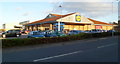
Lidl, Trowbridge
Store located on Canal Road, at the southern edge of an area of depots and factories (light industry) in Canal Road Industrial Estate.
Image: © Jaggery
Taken: 5 Dec 2011
0.13 miles
8

Christmas Decorations
A seasonally dressed residence in Avonvale Road, Trowbridge.
Image: © Phil Williams
Taken: 18 Dec 2005
0.13 miles
9
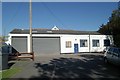
Trowbridge old fire station
Trowbridge old fire station, Lower Court, Trowbridge, Wiltshire
Image: © Kevin Hale
Taken: 5 Oct 2007
0.14 miles
10
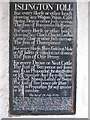
The tariff at Islington Toll
A detail view of the board in the porch of Islington toll house giving the tariff for various items. Note the sum of one penny to take your ass along the road!
Image: © Phil Williams
Taken: 2 Mar 2006
0.15 miles