IMAGES TAKEN NEAR TO
Westcroft Street, TROWBRIDGE, BA14 8NA
Introduction
This page details the photographs taken nearby to Westcroft Street, BA14 8NA by members of the Geograph project.
The Geograph project started in 2005 with the aim of publishing, organising and preserving representative images for every square kilometre of Great Britain, Ireland and the Isle of Man.

There are currently over 7.5m images from over14,400 individuals and you can help contribute to the project by visiting https://www.geograph.org.uk
Image Map
Images are licensed for reuse under creativecommons.org/licenses/by-sa/2.0
Notes
- Clicking on the map will re-center to the selected point.
- The higher the marker number, the further away the image location is from the centre of the postcode.
Image Listing (102 Images Found)
Images are licensed for reuse under creativecommons.org/licenses/by-sa/2.0
Image
Details
Distance
1
![Trowbridge buildings [4]](https://s3.geograph.org.uk/geophotos/06/79/97/6799715_37d16070_120x120.jpg)
Trowbridge buildings [4]
The Twelve Bells, 2 Seymour Road, is a substantial if unremarkable public house.
A market town and county town of Wiltshire, Trowbridge lies on the River Biss, 6 miles (10 kilometres) south of Bath. The town developed as a centre for woollen cloth production from the 14th century, which from the 17th century became increasingly industrialized, so much so that, in 1820, Trowbridge was described as the "Manchester of the West" with over 20 woollen cloth producing factories. The Kennet and Avon Canal runs just to the north of the town and both the Wessex Main Line (Bristol–Westbury–Southampton) and the Heart of Wessex Line (Bristol–Westbury–Weymouth) railways.
Image: © Michael Dibb
Taken: 14 Jan 2021
0.04 miles
2
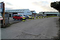
Northern edge of Shanley's premises, Trowbridge
This access road from Shails Lane into the E.J.Shanley and Son Ltd site is for authorised personnel only. The main entrance http://www.geograph.org.uk/photo/2759264 is lower down Shails Lane.
Image: © Jaggery
Taken: 5 Dec 2011
0.06 miles
3

The Oyster fish bar, Trowbridge
Charles Street fish and chip shop located near the Melton Road junction.
The vacant premises on the right was formerly Alliance Foodstores.
Image: © Jaggery
Taken: 5 Dec 2011
0.08 miles
4
![Trowbridge ways [1]](https://s0.geograph.org.uk/geophotos/06/79/70/6797072_ddf2fb28_120x120.jpg)
Trowbridge ways [1]
This path runs from Seymour Road to British Row. See also Image
A market town and county town of Wiltshire, Trowbridge lies on the River Biss, 6 miles (10 kilometres) south of Bath. The town developed as a centre for woollen cloth production from the 14th century, which from the 17th century became increasingly industrialized, so much so that, in 1820, Trowbridge was described as the "Manchester of the West" with over 20 woollen cloth producing factories. The Kennet and Avon Canal runs just to the north of the town and both the Wessex Main Line (Bristol–Westbury–Southampton) and the Heart of Wessex Line (Bristol–Westbury–Weymouth) railways.
Image: © Michael Dibb
Taken: 14 Jan 2021
0.09 miles
5
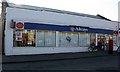
2007 : Post Office on Seymour Road, Trowbridge
Image: © Maurice Pullin
Taken: 3 Nov 2007
0.09 miles
6
![Trowbridge houses [10]](https://s1.geograph.org.uk/geophotos/06/79/97/6799713_58076d4d_120x120.jpg)
Trowbridge houses [10]
Holly House, number 25 Conigre, is the surviving house of a terrace. Built in the early 19th century of brick with stone bands and quoins on the right. Listed, grade II, with details at: https://historicengland.org.uk/listing/the-list/list-entry/1021553
A market town and county town of Wiltshire, Trowbridge lies on the River Biss, 6 miles (10 kilometres) south of Bath. The town developed as a centre for woollen cloth production from the 14th century, which from the 17th century became increasingly industrialized, so much so that, in 1820, Trowbridge was described as the "Manchester of the West" with over 20 woollen cloth producing factories. The Kennet and Avon Canal runs just to the north of the town and both the Wessex Main Line (Bristol–Westbury–Southampton) and the Heart of Wessex Line (Bristol–Westbury–Weymouth) railways.
Image: © Michael Dibb
Taken: 14 Jan 2021
0.11 miles
7
![A walk from Trowbridge to Bradford-on-Avon [10]](https://s2.geograph.org.uk/geophotos/07/40/22/7402250_6b91399b_120x120.jpg)
A walk from Trowbridge to Bradford-on-Avon [10]
The path continues to run alongside the railway.
The walk starts at Trowbridge railway station and initially follows both the railway line and the River Bliss northwards. The river and the railway both pass under the Kennet and Avon Canal and the canal towpath is taken heading west towards Bradford-on-Avon. Leaving the canal, a short walk through streets leads to the railway station for a train back to the starting point at Trowbridge. Just under 3¾ miles.
Image: © Michael Dibb
Taken: 26 Jan 2023
0.11 miles
8
![Trowbridge houses [11]](https://s2.geograph.org.uk/geophotos/06/79/97/6799714_06e337d3_120x120.jpg)
Trowbridge houses [11]
Beechwood House, Conigre, was built in brick with an ashlar double front in the late 18th century. The house was altered in the mid 19th century when the two square bay windows were inserted. There is a mansard roof. The property has been divided into flats. Listed, grade II, with details at: https://historicengland.org.uk/listing/the-list/list-entry/1021554
A market town and county town of Wiltshire, Trowbridge lies on the River Biss, 6 miles (10 kilometres) south of Bath. The town developed as a centre for woollen cloth production from the 14th century, which from the 17th century became increasingly industrialized, so much so that, in 1820, Trowbridge was described as the "Manchester of the West" with over 20 woollen cloth producing factories. The Kennet and Avon Canal runs just to the north of the town and both the Wessex Main Line (Bristol–Westbury–Southampton) and the Heart of Wessex Line (Bristol–Westbury–Weymouth) railways.
Image: © Michael Dibb
Taken: 14 Jan 2021
0.12 miles
9

Entrance to Shanley's premises, Shails Lane, Trowbridge
The premises of E.J.Shanley and Son Ltd, skip hire and metal recycling centre, is at 43 Shails Lane. There is also a Shanley's site in Warminster. The business recycles, or disposes of, millions of tons of household, commercial and industrial waste each year.
Image: © Jaggery
Taken: 5 Dec 2011
0.12 miles
10

Main entrance to Trowbridge Community Hospital
NHS (National Health Service) hospital viewed across Seymour Road.
Image: © Jaggery
Taken: 5 Dec 2011
0.12 miles