IMAGES TAKEN NEAR TO
Wicker Hill, TROWBRIDGE, BA14 8JU
Introduction
This page details the photographs taken nearby to Wicker Hill, BA14 8JU by members of the Geograph project.
The Geograph project started in 2005 with the aim of publishing, organising and preserving representative images for every square kilometre of Great Britain, Ireland and the Isle of Man.

There are currently over 7.5m images from over14,400 individuals and you can help contribute to the project by visiting https://www.geograph.org.uk
Image Map
Images are licensed for reuse under creativecommons.org/licenses/by-sa/2.0
Notes
- Clicking on the map will re-center to the selected point.
- The higher the marker number, the further away the image location is from the centre of the postcode.
Image Listing (343 Images Found)
Images are licensed for reuse under creativecommons.org/licenses/by-sa/2.0
Image
Details
Distance
1

In need of a little attention
A sign of the times, sadly.
Image: © Neil Owen
Taken: 26 Nov 2013
0.01 miles
2
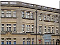
An old name
Originally the Pioneer Pioneer Sick Benefit and Provident Society, this organisation used the 'Holloway Principle' - the allocation of its accumulating funds to the individual members. The name was changed to the Pioneer Benefit Society in 1971, but appears to have ceased business here.
Image: © Neil Owen
Taken: 26 Nov 2013
0.01 miles
3
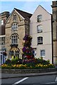
Traffic island and houses on the corner of Hill Street and Fore Street, Trowbridge
Image: © David Martin
Taken: 2 Sep 2018
0.01 miles
4
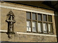
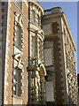
A cross on the wall
An iconic figure on the wall of a small office building in Hill Street, next to the old County Hall.
Image: © Neil Owen
Taken: 5 Nov 2014
0.02 miles
5
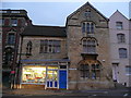
Converted church, Hill Street, Trowbridge
Now a shop and several flats.
Image: © Jonathan Billinger
Taken: 4 Nov 2008
0.02 miles
6

Fore Street, Trowbridge
Looking from Town Bridge (over the River Biss) along Wicker Hill towards Fore Street. The Blind House http://www.geograph.org.uk/photo/2723840 is on the right.
Image: © Jaggery
Taken: 5 Dec 2011
0.02 miles
7
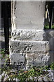
Benchmark on gatepost of #70 Wicker Hill
Ordnance Survey cut mark benchmark described on the Bench Mark Database at http://www.bench-marks.org.uk/bm45514
Image: © Roger Templeman
Taken: 24 Sep 2012
0.03 miles
8
#70 Wicker Hill
There is an OS benchmark Image on the right hand gatepost.
Image: © Roger Templeman
Taken: 24 Sep 2012
0.03 miles
9
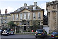
The old County Hall
Wiltshire County Council was first established in 1889 here in Trowbridge. In order to administrate the county several offices had to be used so the move to a purpose building became imperative before long. In 1913, this magnificent suite of offices in Hill Street was founded, with its distinctive features. However, it was not so long after that shortage of space became a problem again and another new building was demanded in 1929. Due to the dispute over whether Trowbridge of Devizes would be the new venue, a new hall was not built until 1933 in Bythesea Road.
Image: © Neil Owen
Taken: 5 Nov 2014
0.03 miles
10
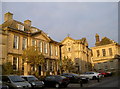
Fore Street splendour
Some of the fine houses on Fore Street, showing the wealth of some of the merchants of Trowbridge, primarily from the wool trade.
Image: © Neil Owen
Taken: 26 Nov 2013
0.04 miles