IMAGES TAKEN NEAR TO
Station Approach, TROWBRIDGE, BA14 8HW
Introduction
This page details the photographs taken nearby to Station Approach, BA14 8HW by members of the Geograph project.
The Geograph project started in 2005 with the aim of publishing, organising and preserving representative images for every square kilometre of Great Britain, Ireland and the Isle of Man.

There are currently over 7.5m images from over14,400 individuals and you can help contribute to the project by visiting https://www.geograph.org.uk
Image Map
Images are licensed for reuse under creativecommons.org/licenses/by-sa/2.0
Notes
- Clicking on the map will re-center to the selected point.
- The higher the marker number, the further away the image location is from the centre of the postcode.
Image Listing (268 Images Found)
Images are licensed for reuse under creativecommons.org/licenses/by-sa/2.0
Image
Details
Distance
1
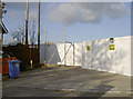
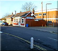
No parking on the footpath
As work continues regarding the demolition of the old Bowyers factories opposite the railway station, the pedestrians are guided by a solid white boarding. The small building that now houses a snack shop is retained.
Image: © Neil Owen
Taken: 5 Nov 2014
0.00 miles
2

Takeaway opposite Trowbridge railway station
In September 2022 La Capricciosa's nameboard shows
"TAKEAWAY PIZZAS & KEBABS" and "FREE HOME DELIVERY".
Image: © Jaggery
Taken: 23 Sep 2022
0.00 miles
3
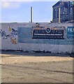
Trowbridge Weavers Market notice
The notice facing Station Approach Trowbridge in September 2022 shows that the market is held from 10am to 4pm once a month (on the dates shown) in Fore Street, Emmanuel's Yard and the Town Hall.
Image: © Jaggery
Taken: 23 Sep 2022
0.01 miles
4
![A walk from Trowbridge to Bradford-on-Avon [1]](https://s2.geograph.org.uk/geophotos/07/40/22/7402234_897cd5b2_120x120.jpg)
A walk from Trowbridge to Bradford-on-Avon [1]
From the forecourt of Trowbridge railway station, the path begins. The hoardings are around the site of the former Bowyers meat processing factory, which has lain derelict since 2009.
The walk starts at Trowbridge railway station and initially follows both the railway line and the River Bliss northwards. The river and the railway both pass under the Kennet and Avon Canal and the canal towpath is taken heading west towards Bradford-on-Avon. Leaving the canal, a short walk through streets leads to the railway station for a train back to the starting point at Trowbridge. Just under 3¾ miles.
Image: © Michael Dibb
Taken: 26 Jan 2023
0.01 miles
5
![A walk from Trowbridge to Bradford-on-Avon [2]](https://s3.geograph.org.uk/geophotos/07/40/22/7402235_c3a41d03_120x120.jpg)
A walk from Trowbridge to Bradford-on-Avon [2]
The path runs between the forecourt of Trowbridge railway station to the left and the derelict site of the former meat processing factory on the right.
The walk starts at Trowbridge railway station and initially follows both the railway line and the River Bliss northwards. The river and the railway both pass under the Kennet and Avon Canal and the canal towpath is taken heading west towards Bradford-on-Avon. Leaving the canal, a short walk through streets leads to the railway station for a train back to the starting point at Trowbridge. Just under 3¾ miles.
Image: © Michael Dibb
Taken: 26 Jan 2023
0.01 miles
6
Town Centre direction sign for walkers, Trowbridge
Alongside Station Approach near Stallard Street.
Image: © Jaggery
Taken: 23 Sep 2022
0.02 miles
7
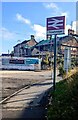
Trowbridge railway station name sign
Alongside Station Approach. The station is behind the camera. Ahead for Stallard Street.
Image: © Jaggery
Taken: 23 Sep 2022
0.02 miles
8
La Capricciosa, Trowbridge
Located on Station Way, on the eastern edge of Trowbridge railway station.
La Capricciosa sells takeaway pizzas and kebabs. There is a free home delivery service.
Image: © Jaggery
Taken: 5 Dec 2011
0.02 miles
9
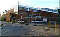
Derelict former Bowyers site, Trowbridge
Viewed along Station Way. From a shop which opened in Trowbridge in the early 19th century, the Bowyers business expanded in the 20th century to become the largest producer of fresh sausages in the UK. Since Bowyers left Trowbridge in 2007, this site has become derelict.
Developer Prorsus has unveiled plans to redevelop the site. Its proposal includes an 8-screen cinema, coffee shops, several restaurants, a riverside walk, a civic square, a Morrisons foodstore, a petrol filling station and a family pub. The scheme proposes c550 free car parking spaces.
Image: © Jaggery
Taken: 5 Dec 2011
0.02 miles
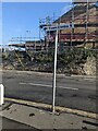
10
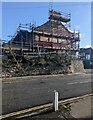
Scaffolding on a corner house, Trowbridge
On the corner of Station Approach and Stallard Street in September 2022.
Image: © Jaggery
Taken: 23 Sep 2022
0.02 miles