IMAGES TAKEN NEAR TO
Fore Street, TROWBRIDGE, BA14 8HQ
Introduction
This page details the photographs taken nearby to Fore Street, BA14 8HQ by members of the Geograph project.
The Geograph project started in 2005 with the aim of publishing, organising and preserving representative images for every square kilometre of Great Britain, Ireland and the Isle of Man.

There are currently over 7.5m images from over14,400 individuals and you can help contribute to the project by visiting https://www.geograph.org.uk
Image Map
Images are licensed for reuse under creativecommons.org/licenses/by-sa/2.0
Notes
- Clicking on the map will re-center to the selected point.
- The higher the marker number, the further away the image location is from the centre of the postcode.
Image Listing (351 Images Found)
Images are licensed for reuse under creativecommons.org/licenses/by-sa/2.0
Image
Details
Distance
1
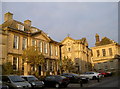
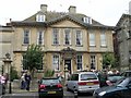
Fore Street splendour
Some of the fine houses on Fore Street, showing the wealth of some of the merchants of Trowbridge, primarily from the wool trade.
Image: © Neil Owen
Taken: 26 Nov 2013
0.01 miles
2
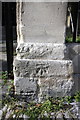
Benchmark on gatepost of #70 Wicker Hill
Ordnance Survey cut mark benchmark described on the Bench Mark Database at http://www.bench-marks.org.uk/bm45514
Image: © Roger Templeman
Taken: 24 Sep 2012
0.02 miles
3
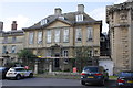
#70 Wicker Hill
There is an OS benchmark Image on the right hand gatepost.
Image: © Roger Templeman
Taken: 24 Sep 2012
0.02 miles
4
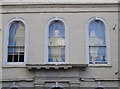
Faceless windows
The upper floor of a recruitment agency in Fore Street.
Image: © Neil Owen
Taken: 26 Nov 2013
0.02 miles
6
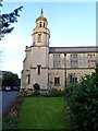
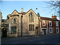
Trowbridge United Church
Viewed from Church Street.
The first church on this site was Tabernacle Congregational Church, formally opened on November 20th 1771. The foundation stone for the current church was laid in 1882, and the church opened in 1884. In 1968, the church was renamed the United Church after the joining of the congregations of the Manvers Street Methodist Church and the Tabernacle Church.
Image: © Jaggery
Taken: 5 Dec 2011
0.03 miles
7
SE corner of Trowbridge United Church grounds
Viewed from Church Street looking towards the church tower. http://www.geograph.org.uk/photo/2759194
Image: © Jaggery
Taken: 5 Dec 2011
0.03 miles
8
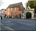
Grade II listed Fernleigh House, Trowbridge
Fernleigh House, 25 Church Street, was built in the 18th century. It is adjacent to the archway entrance to Trowbridge United Church. http://www.geograph.org.uk/photo/2759194 Now used as offices, Fernleigh House was Grade II listed in September 1976.
Image: © Jaggery
Taken: 5 Dec 2011
0.03 miles
9
Grade II listed former Tabernacle Sunday School, Trowbridge
The former Sunday School, dating from 1882, is located on Church Street, adjacent to Trowbridge United Church http://www.geograph.org.uk/photo/2759194 (which was built as the Tabernacle Church).
Grade II listed in November 1976.
Image: © Jaggery
Taken: 5 Dec 2011
0.03 miles
10
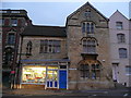
Converted church, Hill Street, Trowbridge
Now a shop and several flats.
Image: © Jonathan Billinger
Taken: 4 Nov 2008
0.03 miles