IMAGES TAKEN NEAR TO
Stallard Street, TROWBRIDGE, BA14 8HH
Introduction
This page details the photographs taken nearby to Stallard Street, BA14 8HH by members of the Geograph project.
The Geograph project started in 2005 with the aim of publishing, organising and preserving representative images for every square kilometre of Great Britain, Ireland and the Isle of Man.

There are currently over 7.5m images from over14,400 individuals and you can help contribute to the project by visiting https://www.geograph.org.uk
Image Map
Images are licensed for reuse under creativecommons.org/licenses/by-sa/2.0
Notes
- Clicking on the map will re-center to the selected point.
- The higher the marker number, the further away the image location is from the centre of the postcode.
Image Listing (326 Images Found)
Images are licensed for reuse under creativecommons.org/licenses/by-sa/2.0
Image
Details
Distance
1
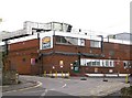
Bowyer's Factory - Stallard Street
Image: © Betty Longbottom
Taken: 26 Aug 2008
0.01 miles
2
Hill Street
Buildings on Hill Street, Trowbridge.
Image: © Wayland Smith
Taken: 4 May 2013
0.01 miles
3
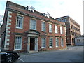
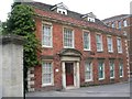
Bridge House and Studley Mill, Trowbridge
Bridge house is early 18th century and was a clothier's house with workshop accommodation to the rear. The mill is an 1860 rebuild of a factory dating from 1825 and was owned by John & Thomas Clark who bought the site from Thomas Deacon.
Information from 'A Guide to the Industrial Archaeology of Wiltshire.
Image: © Chris Allen
Taken: 8 Jan 2012
0.01 miles
4
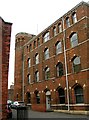
Clark's Mill - off Stallard Street
Image: © Betty Longbottom
Taken: 26 Aug 2008
0.03 miles
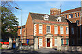
5
County Court - off Stallard Street
Image: © Betty Longbottom
Taken: 26 Aug 2008
0.03 miles
6
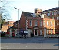
Trowbridge County Court
The court occupies the ground floor of the former Clarks Mill. Viewed across Stallard Street.
Image: © Jaggery
Taken: 5 Dec 2011
0.03 miles
7
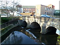
Grade II listed Town Bridge, Trowbridge
The River Biss flows towards Town Bridge, designed by local architect Esau Reynolds and completed in 1777. Grade II listed in December 1950.
Image: © Jaggery
Taken: 5 Dec 2011
0.03 miles
8
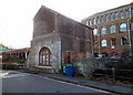
Grade II (Star) listed Handle House, Trowbridge
Built in the 1840s on a bridge over the River Biss. The heavily perforated wall panels were to allow free passage of air for drying teasels. Grade II (Star) listed in 1974. The current occupiers (2011) are Carewatch North West Wiltshire.
Image: © Jaggery
Taken: 5 Dec 2011
0.03 miles
9
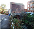
River Biss flows under Handle House, Trowbridge
Grade II* listed Handle House is built on a bridge over the River Biss.
Image: © Jaggery
Taken: 5 Dec 2011
0.03 miles
10
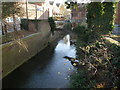
River Biss flows away from Handle House, Trowbridge
The Biss, about 11 miles long, is a tributary of the River Avon. In the distance, it flows under Grade II* listed Handle House, http://www.geograph.org.uk/photo/2725161 towards Town Bridge. http://www.geograph.org.uk/photo/2723988
Image: © Jaggery
Taken: 5 Dec 2011
0.03 miles