IMAGES TAKEN NEAR TO
Church Street, TROWBRIDGE, BA14 8DW
Introduction
This page details the photographs taken nearby to Church Street, BA14 8DW by members of the Geograph project.
The Geograph project started in 2005 with the aim of publishing, organising and preserving representative images for every square kilometre of Great Britain, Ireland and the Isle of Man.

There are currently over 7.5m images from over14,400 individuals and you can help contribute to the project by visiting https://www.geograph.org.uk
Image Map
Images are licensed for reuse under creativecommons.org/licenses/by-sa/2.0
Notes
- Clicking on the map will re-center to the selected point.
- The higher the marker number, the further away the image location is from the centre of the postcode.
Image Listing (299 Images Found)
Images are licensed for reuse under creativecommons.org/licenses/by-sa/2.0
Image
Details
Distance
1

Two newspaper offices, Trowbridge
Neighbours on Duke Street are the offices of the West Wilts Advertiser on the right and The Wiltshire Times on the left.
Image: © Jaggery
Taken: 5 Dec 2011
0.00 miles
2

Brewery Walk, Trowbridge
Viewed from the Duke Street side. The street is near the site of the demolished Ushers Brewery, which closed in 2000.
Image: © Jaggery
Taken: 5 Dec 2011
0.00 miles
3
![Trowbridge houses [22]](https://s1.geograph.org.uk/geophotos/07/43/74/7437461_709cfa84_120x120.jpg)
Trowbridge houses [22]
On the left are numbers 18 and 19 Church Street. Built in the Tudor vernacular style in 1861, and part of a 'L' plan with Union Street Almshouses (see Image). Constructed of rubble stone under tile roofs. Listed, grade II, with details at: https://historicengland.org.uk/listing/the-list/list-entry/1182692
On the right are numbers 16 and 17 Church Street, which incorporate the former National Schools. Built in 1842 in an Elizabethan style with a projecting central gable and 2 projecting subsidiary gables. Constructed of coursed rubble stone with an ashlar front under a slate roof. The two doorways have Tudor arches over with the scrolled inscriptions "Boys' School" and "Girls' School" in Gothic lettering. There is a long rear extension. Listed, grade II, with details at: https://historicengland.org.uk/listing/the-list/list-entry/1021540
A market town and county town of Wiltshire, Trowbridge lies on the River Biss, 6 miles (10 kilometres) south of Bath. The town developed as a centre for woollen cloth production from the 14th century, which from the 17th century became increasingly industrialized, so much so that, in 1820, Trowbridge was described as the "Manchester of the West" with over 20 woollen cloth producing factories. The Kennet and Avon Canal runs just to the north of the town and both the Wessex Main Line (Bristol–Westbury–Southampton) and the Heart of Wessex Line (Bristol–Westbury–Weymouth) railways serve the station.
Image: © Michael Dibb
Taken: 14 Feb 2023
0.01 miles
4
![Trowbridge buildings [10]](https://s1.geograph.org.uk/geophotos/07/43/74/7437465_30efcccb_120x120.jpg)
Trowbridge buildings [10]
Set well back from the street is Emmanuel Baptist Church. The church was founded in 1736, renovated in 1902 and closed and renovated in 2010. Now used as an event space with various sizes of rooms available for hire. Constructed of ashlar with a Doric portico in antis, all under a slate roof. The interior has a gallery on all sides with curved corners. Listed, grade II, with details at: https://historicengland.org.uk/listing/the-list/list-entry/1021539
A market town and county town of Wiltshire, Trowbridge lies on the River Biss, 6 miles (10 kilometres) south of Bath. The town developed as a centre for woollen cloth production from the 14th century, which from the 17th century became increasingly industrialized, so much so that, in 1820, Trowbridge was described as the "Manchester of the West" with over 20 woollen cloth producing factories. The Kennet and Avon Canal runs just to the north of the town and both the Wessex Main Line (Bristol–Westbury–Southampton) and the Heart of Wessex Line (Bristol–Westbury–Weymouth) railways serve the station.
Image: © Michael Dibb
Taken: 14 Feb 2023
0.02 miles
5
![Trowbridge houses [24]](https://s3.geograph.org.uk/geophotos/07/43/82/7438207_c9477e00_120x120.jpg)
Trowbridge houses [24]
Numbers 1 to 4 Union Street are almshouses. Built in 1861 in a Tudor vernacular style. Constructed of rubble stone and brick under a tile roof. The almshouses form a 'L' plan with numbers 18 and 19 Church Street (see Image). The main front has a covered porch loggia to the first and stone arches to the ground floor. Listed, grade II, with details at: https://historicengland.org.uk/listing/the-list/list-entry/1021663
A market town and county town of Wiltshire, Trowbridge lies on the River Biss, 6 miles (10 kilometres) south of Bath. The town developed as a centre for woollen cloth production from the 14th century, which from the 17th century became increasingly industrialized, so much so that, in 1820, Trowbridge was described as the "Manchester of the West" with over 20 woollen cloth producing factories. The Kennet and Avon Canal runs just to the north of the town and both the Wessex Main Line (Bristol–Westbury–Southampton) and the Heart of Wessex Line (Bristol–Westbury–Weymouth) railways serve the station.
Image: © Michael Dibb
Taken: 14 Feb 2023
0.02 miles
6
![Trowbridge buildings [9]](https://s1.geograph.org.uk/geophotos/07/43/74/7437437_dec28205_120x120.jpg)
Trowbridge buildings [9]
Number 9 Church Street was built in the 17th century and has been greatly altered. Set with a jettied gable end to the street. Partly timber framed, the rest partly built of rubble stone and partly built of brick. All under a double Roman tile roof. Listed, grade II, with details at: https://historicengland.org.uk/listing/the-list/list-entry/1021537
A market town and county town of Wiltshire, Trowbridge lies on the River Biss, 6 miles (10 kilometres) south of Bath. The town developed as a centre for woollen cloth production from the 14th century, which from the 17th century became increasingly industrialized, so much so that, in 1820, Trowbridge was described as the "Manchester of the West" with over 20 woollen cloth producing factories. The Kennet and Avon Canal runs just to the north of the town and both the Wessex Main Line (Bristol–Westbury–Southampton) and the Heart of Wessex Line (Bristol–Westbury–Weymouth) railways serve the station.
Image: © Michael Dibb
Taken: 14 Feb 2023
0.02 miles
7
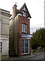
Narrow margins
A row of shops and offices front onto the grounds of St James church. However, a small alleyway (Bowles Court) runs down the back, affording a very short floorspace. See Image] for a date detail.
Image: © Neil Owen
Taken: 26 Nov 2013
0.03 miles
8
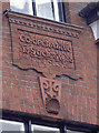
The Co-op shop
Detail from the narrow office that looks onto St James, showing its roots. See Image] for a wider view.
Image: © Neil Owen
Taken: 26 Nov 2013
0.03 miles
9
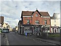
Church Walk, Trowbridge
The building housing "Safe and Sound" is inscribed: Co-operative Society 1888
Image: © David Smith
Taken: 8 Jun 2017
0.03 miles
