IMAGES TAKEN NEAR TO
Mortimer Street, TROWBRIDGE, BA14 8BN
Introduction
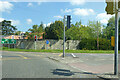
This page details the photographs taken nearby to Mortimer Street, BA14 8BN by members of the Geograph project.
The Geograph project started in 2005 with the aim of publishing, organising and preserving representative images for every square kilometre of Great Britain, Ireland and the Isle of Man.

There are currently over 7.5m images from over14,400 individuals and you can help contribute to the project by visiting https://www.geograph.org.uk
Image Map
Images are licensed for reuse under creativecommons.org/licenses/by-sa/2.0
Notes
- Clicking on the map will re-center to the selected point.
- The higher the marker number, the further away the image location is from the centre of the postcode.
Image Listing (57 Images Found)
Images are licensed for reuse under creativecommons.org/licenses/by-sa/2.0
Image
Details
Distance
2
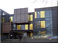
Hall of Mirrors
The modern entrances to County Hall, featuring some energy efficient glazing.
Image: © Neil Owen
Taken: 26 Nov 2013
0.06 miles
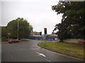
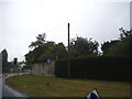
3
Tree on County Way, Trowbridge
This roundabout is so large it has houses on it. I can't imagine wanting to live in the middle of an urban roundabout but people clearly do.
Image: © David Howard
Taken: 21 Aug 2016
0.06 miles
5
Roads around Longfield House, Trowbridge
A large roundabout or small one-way system around the house and grounds. The house (hidden here) dates from the late 18th century, the road system is modern. The wall appears to be partly modern too, to suit the road layout. The tall narrow recess looks as if it is an old feature built into a modern wall. What was once in it?
Image: © Robin Webster
Taken: 30 May 2021
0.07 miles
7
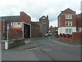
Court Street, Trowbridge
This area is likely to be redeveloped over the next few years.
Image: © Danny P Robinson
Taken: 10 Mar 2006
0.09 miles
8
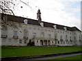
County Hall
Wiltshire's centre of administration; it was revamped at a cost of around £24 million in 2012. It is now the place of Wiltshire Council, which replaced the old Wiltshire County Council of 1889–2009. See Image] for a closer look at the cupola.
Image: © Neil Owen
Taken: 26 Nov 2013
0.10 miles
9
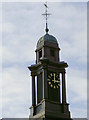
County Hall cupola
The crowning piece of the large administration centre for Wiltshire. See Image] for a wider view.
Image: © Neil Owen
Taken: 26 Nov 2013
0.10 miles
10

Wiltshire County Council Council offices
The cupola is an Ordnance Survey intersected station triangulation point, see http://www.trigpointinguk.com/trigs/trig-details.php?t=9401
Image: © Roger Templeman
Taken: 24 Sep 2012
0.11 miles