IMAGES TAKEN NEAR TO
Rodway Close, TROWBRIDGE, BA14 7UQ
Introduction
This page details the photographs taken nearby to Rodway Close, BA14 7UQ by members of the Geograph project.
The Geograph project started in 2005 with the aim of publishing, organising and preserving representative images for every square kilometre of Great Britain, Ireland and the Isle of Man.

There are currently over 7.5m images from over14,400 individuals and you can help contribute to the project by visiting https://www.geograph.org.uk
Image Map
Images are licensed for reuse under creativecommons.org/licenses/by-sa/2.0
Notes
- Clicking on the map will re-center to the selected point.
- The higher the marker number, the further away the image location is from the centre of the postcode.
Image Listing (41 Images Found)
Images are licensed for reuse under creativecommons.org/licenses/by-sa/2.0
Image
Details
Distance
1
![Trowbridge, The Down Cemetery [5]](https://s2.geograph.org.uk/geophotos/06/79/97/6799758_5e7c5ef0_120x120.jpg)
Trowbridge, The Down Cemetery [5]
Central entrance of 2 orders of the mausoleum seen at Image The central door has decorative hinge and handle fretwork of wrought iron. Listed, grade II, with details at: https://historicengland.org.uk/listing/the-list/list-entry/1021562
The land for The Down Cemetery was purchased and the cemetery laid out in 1854-55 with a broad central avenue dividing the consecrated and unconsecrated sections, two chapels, a lodge, and serpentine outer walks. The cemetery is on the Register of Historic Parks and Gardens, grade II, with much detail at: https://historicengland.org.uk/listing/the-list/list-entry/1001587. The 20th century extension to the south east is outside the listing.
A market town and county town of Wiltshire, Trowbridge lies on the River Biss, 6 miles (10 kilometres) south of Bath. The town developed as a centre for woollen cloth production from the 14th century, which from the 17th century became increasingly industrialized, so much so that, in 1820, Trowbridge was described as the "Manchester of the West" with over 20 woollen cloth producing factories. The Kennet and Avon Canal runs just to the north of the town and both the Wessex Main Line (Bristol–Westbury–Southampton) and the Heart of Wessex Line (Bristol–Westbury–Weymouth) railways.
Image: © Michael Dibb
Taken: 14 Jan 2021
0.06 miles
2
![Trowbridge, The Down Cemetery [4]](https://s3.geograph.org.uk/geophotos/06/79/97/6799755_68454072_120x120.jpg)
Trowbridge, The Down Cemetery [4]
This fine mausoleum was constructed circa 1870. A Romanesque style stone vault with bronze plates to the Rev Thomas Kingston (died 1867) and to Rev J D Hastings- Trowbridge, (died 1869), both with shields above. A closer view of the central doorway is at Image Listed, grade II, with details at: https://historicengland.org.uk/listing/the-list/list-entry/1021562
The land for The Down Cemetery was purchased and the cemetery laid out in 1854-55 with a broad central avenue dividing the consecrated and unconsecrated sections, two chapels, a lodge, and serpentine outer walks. The cemetery is on the Register of Historic Parks and Gardens, grade II, with much detail at: https://historicengland.org.uk/listing/the-list/list-entry/1001587. The 20th century extension to the south east is outside the listing.
A market town and county town of Wiltshire, Trowbridge lies on the River Biss, 6 miles (10 kilometres) south of Bath. The town developed as a centre for woollen cloth production from the 14th century, which from the 17th century became increasingly industrialized, so much so that, in 1820, Trowbridge was described as the "Manchester of the West" with over 20 woollen cloth producing factories. The Kennet and Avon Canal runs just to the north of the town and both the Wessex Main Line (Bristol–Westbury–Southampton) and the Heart of Wessex Line (Bristol–Westbury–Weymouth) railways.
Image: © Michael Dibb
Taken: 14 Jan 2021
0.06 miles
3
![Trowbridge, The Down Cemetery [3]](https://s2.geograph.org.uk/geophotos/06/79/97/6799738_a42eb978_120x120.jpg)
Trowbridge, The Down Cemetery [3]
This fine monument was erected circa 1870 as the tomb of Thomas Clark. It is an open arcaded cruciform reliquary type with Purbeck shafts. Surrounded by a box hedge. Listed, grade II, with details at: https://historicengland.org.uk/listing/the-list/list-entry/1021560
The land for The Down Cemetery was purchased and the cemetery laid out in 1854-55 with a broad central avenue dividing the consecrated and unconsecrated sections, two chapels, a lodge, and serpentine outer walks. The cemetery is on the Register of Historic Parks and Gardens, grade II, with much detail at: https://historicengland.org.uk/listing/the-list/list-entry/1001587. The 20th century extension to the south east is outside the listing.
A market town and county town of Wiltshire, Trowbridge lies on the River Biss, 6 miles (10 kilometres) south of Bath. The town developed as a centre for woollen cloth production from the 14th century, which from the 17th century became increasingly industrialized, so much so that, in 1820, Trowbridge was described as the "Manchester of the West" with over 20 woollen cloth producing factories. The Kennet and Avon Canal runs just to the north of the town and both the Wessex Main Line (Bristol–Westbury–Southampton) and the Heart of Wessex Line (Bristol–Westbury–Weymouth) railways.
Image: © Michael Dibb
Taken: 14 Jan 2021
0.07 miles
4
![Trowbridge, The Down Cemetery [2]](https://s1.geograph.org.uk/geophotos/06/79/97/6799733_5c83f2fe_120x120.jpg)
Trowbridge, The Down Cemetery [2]
A general view of the cemetery.
The land for The Down Cemetery was purchased and the cemetery laid out in 1854-55 with a broad central avenue dividing the consecrated and unconsecrated sections, two chapels, a lodge, and serpentine outer walks. The cemetery is on the Register of Historic Parks and Gardens, grade II, with much detail at: https://historicengland.org.uk/listing/the-list/list-entry/1001587. The 20th century extension to the south east is outside the listing.
A market town and county town of Wiltshire, Trowbridge lies on the River Biss, 6 miles (10 kilometres) south of Bath. The town developed as a centre for woollen cloth production from the 14th century, which from the 17th century became increasingly industrialized, so much so that, in 1820, Trowbridge was described as the "Manchester of the West" with over 20 woollen cloth producing factories. The Kennet and Avon Canal runs just to the north of the town and both the Wessex Main Line (Bristol–Westbury–Southampton) and the Heart of Wessex Line (Bristol–Westbury–Weymouth) railways.
Image: © Michael Dibb
Taken: 14 Jan 2021
0.09 miles
5
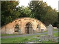
![Trowbridge, The Down Cemetery [1]](https://s1.geograph.org.uk/geophotos/06/79/97/6799725_1c81d8f3_120x120.jpg)
Trowbridge, The Down Cemetery [1]
The lodge and entrance gates to the cemetery from The Down.
The Gothic style lodge in coursed and dressed stone was built in 1855. Listed, grade II, with details at: https://historicengland.org.uk/listing/the-list/list-entry/1284283
The gates, gate piers and flanking wall and railings are from 1855. Listed, grade II, with details at: https://historicengland.org.uk/listing/the-list/list-entry/1021561
The land for The Down Cemetery was purchased and the cemetery laid out in 1854-55 with a broad central avenue dividing the consecrated and unconsecrated sections, two chapels, a lodge, and serpentine outer walks. The cemetery is on the Register of Historic Parks and Gardens, grade II, with much detail at: https://historicengland.org.uk/listing/the-list/list-entry/1001587. The 20th century extension to the south east is outside the listing.
A market town and county town of Wiltshire, Trowbridge lies on the River Biss, 6 miles (10 kilometres) south of Bath. The town developed as a centre for woollen cloth production from the 14th century, which from the 17th century became increasingly industrialized, so much so that, in 1820, Trowbridge was described as the "Manchester of the West" with over 20 woollen cloth producing factories. The Kennet and Avon Canal runs just to the north of the town and both the Wessex Main Line (Bristol–Westbury–Southampton) and the Heart of Wessex Line (Bristol–Westbury–Weymouth) railways.
Image: © Michael Dibb
Taken: 14 Jan 2021
0.11 miles
6
Kingdom & Hastings Mausoleum
John David Hastings & Rev. Thomas Kingdom.
Image: © Jeff Tomlinson
Taken: 9 Jul 2004
0.11 miles
7
![Trowbridge, The Down Cemetery [10]](https://s1.geograph.org.uk/geophotos/06/80/18/6801805_68420b2f_120x120.jpg)
Trowbridge, The Down Cemetery [10]
A view of the Anglican south mortuary chapel. The chapel was built 1854-55, in stone, in the Early English style. There is another view of the chapel at Image Listed, grade II, with details at: https://historicengland.org.uk/listing/the-list/list-entry/1021559
The land for The Down Cemetery was purchased and the cemetery laid out in 1854-55 with a broad central avenue dividing the consecrated and unconsecrated sections, two chapels, a lodge, and serpentine outer walks. The cemetery is on the Register of Historic Parks and Gardens, grade II, with much detail at: https://historicengland.org.uk/listing/the-list/list-entry/1001587. The 20th century extension to the south east is outside the listing.
A market town and county town of Wiltshire, Trowbridge lies on the River Biss, 6 miles (10 kilometres) south of Bath. The town developed as a centre for woollen cloth production from the 14th century, which from the 17th century became increasingly industrialized, so much so that, in 1820, Trowbridge was described as the "Manchester of the West" with over 20 woollen cloth producing factories. The Kennet and Avon Canal runs just to the north of the town and both the Wessex Main Line (Bristol–Westbury–Southampton) and the Heart of Wessex Line (Bristol–Westbury–Weymouth) railways.
Image: © Michael Dibb
Taken: 14 Jan 2021
0.11 miles
8
![Trowbridge, The Down Cemetery [6]](https://s1.geograph.org.uk/geophotos/06/80/18/6801801_0374a31c_120x120.jpg)
Trowbridge, The Down Cemetery [6]
The Anglican south mortuary chapel is seen from the perimeter path. The chapel was built 1854-55, in stone, in the Early English style. There is another view of the chapel at Image Listed, grade II, with details at: https://historicengland.org.uk/listing/the-list/list-entry/1021559
The land for The Down Cemetery was purchased and the cemetery laid out in 1854-55 with a broad central avenue dividing the consecrated and unconsecrated sections, two chapels, a lodge, and serpentine outer walks. The cemetery is on the Register of Historic Parks and Gardens, grade II, with much detail at: https://historicengland.org.uk/listing/the-list/list-entry/1001587. The 20th century extension to the south east is outside the listing.
A market town and county town of Wiltshire, Trowbridge lies on the River Biss, 6 miles (10 kilometres) south of Bath. The town developed as a centre for woollen cloth production from the 14th century, which from the 17th century became increasingly industrialized, so much so that, in 1820, Trowbridge was described as the "Manchester of the West" with over 20 woollen cloth producing factories. The Kennet and Avon Canal runs just to the north of the town and both the Wessex Main Line (Bristol–Westbury–Southampton) and the Heart of Wessex Line (Bristol–Westbury–Weymouth) railways.
Image: © Michael Dibb
Taken: 14 Jan 2021
0.11 miles

10
![Trowbridge, The Down Cemetery [12]](https://s3.geograph.org.uk/geophotos/06/80/18/6801807_585a0548_120x120.jpg)
Trowbridge, The Down Cemetery [12]
A view of the Nonconformist north mortuary chapel. The chapel was built 1854-55, in stone, in the Early English style. Listed, grade II, with details at: https://historicengland.org.uk/listing/the-list/list-entry/1182994
The land for The Down Cemetery was purchased and the cemetery laid out in 1854-55 with a broad central avenue dividing the consecrated and unconsecrated sections, two chapels, a lodge, and serpentine outer walks. The cemetery is on the Register of Historic Parks and Gardens, grade II, with much detail at: https://historicengland.org.uk/listing/the-list/list-entry/1001587. The 20th century extension to the south east is outside the listing.
A market town and county town of Wiltshire, Trowbridge lies on the River Biss, 6 miles (10 kilometres) south of Bath. The town developed as a centre for woollen cloth production from the 14th century, which from the 17th century became increasingly industrialized, so much so that, in 1820, Trowbridge was described as the "Manchester of the West" with over 20 woollen cloth producing factories. The Kennet and Avon Canal runs just to the north of the town and both the Wessex Main Line (Bristol–Westbury–Southampton) and the Heart of Wessex Line (Bristol–Westbury–Weymouth) railways.
Image: © Michael Dibb
Taken: 14 Jan 2021
0.12 miles