IMAGES TAKEN NEAR TO
Wyke Road, TROWBRIDGE, BA14 7NP
Introduction
This page details the photographs taken nearby to Wyke Road, BA14 7NP by members of the Geograph project.
The Geograph project started in 2005 with the aim of publishing, organising and preserving representative images for every square kilometre of Great Britain, Ireland and the Isle of Man.

There are currently over 7.5m images from over14,400 individuals and you can help contribute to the project by visiting https://www.geograph.org.uk
Image Map
Images are licensed for reuse under creativecommons.org/licenses/by-sa/2.0
Notes
- Clicking on the map will re-center to the selected point.
- The higher the marker number, the further away the image location is from the centre of the postcode.
Image Listing (31 Images Found)
Images are licensed for reuse under creativecommons.org/licenses/by-sa/2.0
Image
Details
Distance
1
![Trowbridge houses [14]](https://s1.geograph.org.uk/geophotos/06/80/18/6801821_dae2464b_120x120.jpg)
Trowbridge houses [14]
Numbers 1 and 3 Victoria Road are two semi-detached houses. Built in the mid 19th century, in ashlar with two-storey canted bay windows. Listed, grade II, with details at: https://historicengland.org.uk/listing/the-A market town and county town of Wiltshire, Trowbridge lies on the River Biss, 6 miles (10 kilometres) south of Bath. The town developed as a centre for woollen cloth production from the 14th century, which from the 17th century became increasingly industrialized, so much so that, in 1820, Trowbridge was described as the "Manchester of the West" with over 20 woollen cloth producing factories. The Kennet and Avon Canal runs just to the north of the town and both the Wessex Main Line (Bristol–Westbury–Southampton) and the Heart of Wessex Line (Bristol–Westbury–Weymouth) railways. list/list-entry/1364189
Image: © Michael Dibb
Taken: 14 Jan 2021
0.11 miles
2

Wickes Home Improvement Centre, Trowbridge
Located on Kennet Way in the Canal Road Industrial Estate. This is one of about 200 Wickes stores in the UK. Wickes is a retailer selling supplies and materials for DIY and home improvement, and garden supplies.
Image: © Jaggery
Taken: 5 Dec 2011
0.14 miles
3
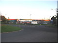
Canal Road roundabout and DIY store, Trowbridge
looking east across the Canal road roundabout to a large DIY store catching the last of the November evening sun.
Image: © Phil Williams
Taken: 18 Nov 2005
0.14 miles
4
![Trowbridge houses [12]](https://s1.geograph.org.uk/geophotos/06/80/18/6801817_1456634f_120x120.jpg)
Trowbridge houses [12]
Rock Villa, number 13 Victoria Road, is a mid 19th century house. Built in ashlar in the Georgian style. Listed, grade II, with details at: https://historicengland.org.uk/listing/the-list/list-entry/1198795
The walls and gate piers are separately listed, grade II, with details at: https://historicengland.org.uk/listing/the-list/list-entry/1021667
A market town and county town of Wiltshire, Trowbridge lies on the River Biss, 6 miles (10 kilometres) south of Bath. The town developed as a centre for woollen cloth production from the 14th century, which from the 17th century became increasingly industrialized, so much so that, in 1820, Trowbridge was described as the "Manchester of the West" with over 20 woollen cloth producing factories. The Kennet and Avon Canal runs just to the north of the town and both the Wessex Main Line (Bristol–Westbury–Southampton) and the Heart of Wessex Line (Bristol–Westbury–Weymouth) railways.
Image: © Michael Dibb
Taken: 14 Jan 2021
0.15 miles
5
![Trowbridge houses [13]](https://s0.geograph.org.uk/geophotos/06/80/18/6801820_b2797785_120x120.jpg)
Trowbridge houses [13]
Numbers 15 and 17 Victoria Road are two mid 19th century houses in ashlar. Listed, grade II, with details at: https://historicengland.org.uk/listing/the-list/list-entry/1021668
A market town and county town of Wiltshire, Trowbridge lies on the River Biss, 6 miles (10 kilometres) south of Bath. The town developed as a centre for woollen cloth production from the 14th century, which from the 17th century became increasingly industrialized, so much so that, in 1820, Trowbridge was described as the "Manchester of the West" with over 20 woollen cloth producing factories. The Kennet and Avon Canal runs just to the north of the town and both the Wessex Main Line (Bristol–Westbury–Southampton) and the Heart of Wessex Line (Bristol–Westbury–Weymouth) railways.
Image: © Michael Dibb
Taken: 14 Jan 2021
0.16 miles
6
![Trowbridge, The Down Cemetery [15]](https://s2.geograph.org.uk/geophotos/06/80/18/6801810_b70a7678_120x120.jpg)
Trowbridge, The Down Cemetery [15]
This fine, domed mausoleum was erected circa 1903 in pink granite. The bronze gate, now removed, had the motto "I have the keys of Death and Hades". Listed, grade II, with details at: https://historicengland.org.uk/listing/the-list/list-entry/1284251
The land for The Down Cemetery was purchased and the cemetery laid out in 1854-55 with a broad central avenue dividing the consecrated and unconsecrated sections, two chapels, a lodge, and serpentine outer walks. The cemetery is on the Register of Historic Parks and Gardens, grade II, with much detail at: https://historicengland.org.uk/listing/the-list/list-entry/1001587. The 20th century extension to the south east is outside the listing.
A market town and county town of Wiltshire, Trowbridge lies on the River Biss, 6 miles (10 kilometres) south of Bath. The town developed as a centre for woollen cloth production from the 14th century, which from the 17th century became increasingly industrialized, so much so that, in 1820, Trowbridge was described as the "Manchester of the West" with over 20 woollen cloth producing factories. The Kennet and Avon Canal runs just to the north of the town and both the Wessex Main Line (Bristol–Westbury–Southampton) and the Heart of Wessex Line (Bristol–Westbury–Weymouth) railways.
Image: © Michael Dibb
Taken: 14 Jan 2021
0.16 miles
7
![Trowbridge, The Down Cemetery [16]](https://s3.geograph.org.uk/geophotos/06/80/18/6801811_35f0a7b9_120x120.jpg)
Trowbridge, The Down Cemetery [16]
Alongside the domed mausoleum seen at Image is this simple monument.
The land for The Down Cemetery was purchased and the cemetery laid out in 1854-55 with a broad central avenue dividing the consecrated and unconsecrated sections, two chapels, a lodge, and serpentine outer walks. The cemetery is on the Register of Historic Parks and Gardens, grade II, with much detail at: https://historicengland.org.uk/listing/the-list/list-entry/1001587. The 20th century extension to the south east is outside the listing.
A market town and county town of Wiltshire, Trowbridge lies on the River Biss, 6 miles (10 kilometres) south of Bath. The town developed as a centre for woollen cloth production from the 14th century, which from the 17th century became increasingly industrialized, so much so that, in 1820, Trowbridge was described as the "Manchester of the West" with over 20 woollen cloth producing factories. The Kennet and Avon Canal runs just to the north of the town and both the Wessex Main Line (Bristol–Westbury–Southampton) and the Heart of Wessex Line (Bristol–Westbury–Weymouth) railways.
Image: © Michael Dibb
Taken: 14 Jan 2021
0.16 miles
8

Trowbridge : Kennet Way
Looking along Kennet Way from the roundabout.
Image: © Lewis Clarke
Taken: 18 Oct 2022
0.17 miles
10
![Trowbridge, The Down Cemetery [1]](https://s1.geograph.org.uk/geophotos/06/79/97/6799725_1c81d8f3_120x120.jpg)
Trowbridge, The Down Cemetery [1]
The lodge and entrance gates to the cemetery from The Down.
The Gothic style lodge in coursed and dressed stone was built in 1855. Listed, grade II, with details at: https://historicengland.org.uk/listing/the-list/list-entry/1284283
The gates, gate piers and flanking wall and railings are from 1855. Listed, grade II, with details at: https://historicengland.org.uk/listing/the-list/list-entry/1021561
The land for The Down Cemetery was purchased and the cemetery laid out in 1854-55 with a broad central avenue dividing the consecrated and unconsecrated sections, two chapels, a lodge, and serpentine outer walks. The cemetery is on the Register of Historic Parks and Gardens, grade II, with much detail at: https://historicengland.org.uk/listing/the-list/list-entry/1001587. The 20th century extension to the south east is outside the listing.
A market town and county town of Wiltshire, Trowbridge lies on the River Biss, 6 miles (10 kilometres) south of Bath. The town developed as a centre for woollen cloth production from the 14th century, which from the 17th century became increasingly industrialized, so much so that, in 1820, Trowbridge was described as the "Manchester of the West" with over 20 woollen cloth producing factories. The Kennet and Avon Canal runs just to the north of the town and both the Wessex Main Line (Bristol–Westbury–Southampton) and the Heart of Wessex Line (Bristol–Westbury–Weymouth) railways.
Image: © Michael Dibb
Taken: 14 Jan 2021
0.19 miles