IMAGES TAKEN NEAR TO
Hilperton Road, TROWBRIDGE, BA14 7JN
Introduction
This page details the photographs taken nearby to Hilperton Road, BA14 7JN by members of the Geograph project.
The Geograph project started in 2005 with the aim of publishing, organising and preserving representative images for every square kilometre of Great Britain, Ireland and the Isle of Man.

There are currently over 7.5m images from over14,400 individuals and you can help contribute to the project by visiting https://www.geograph.org.uk
Image Map
Images are licensed for reuse under creativecommons.org/licenses/by-sa/2.0
Notes
- Clicking on the map will re-center to the selected point.
- The higher the marker number, the further away the image location is from the centre of the postcode.
Image Listing (28 Images Found)
Images are licensed for reuse under creativecommons.org/licenses/by-sa/2.0
Image
Details
Distance
1
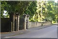
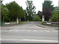
Gate to an old house, Hilperton Road, Trowbridge
These were the walls and gates of the house called Springfield, now remembered in the road Springfield Close
Image: © David Smith
Taken: 8 Jun 2017
0.04 miles
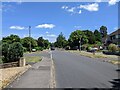


5
Rear of houses on Hilperton Road, Trowbridge
The houses are on Grasmere
Image: © David Howard
Taken: 21 Aug 2016
0.14 miles
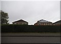
6
Larkrise Boarding Cattery, Trowbridge
Image: © Julian P Guffogg
Taken: 29 Sep 2018
0.14 miles
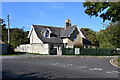
7
Ravenscroft Gardens
An old map shows a house called Ravenscroft dating from the first quarter of the 20th century. This road leads to a small housing estate
Image: © David Smith
Taken: 8 Jun 2017
0.14 miles
8
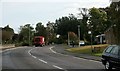
2007 : The A361 out of Trowbridge
Just beyond Bellefield House the A361 takes the traveller through Hilperton and on to Devizes, if he follows it far enough it will take him to Leicester.
The Trowbridge Fire Station is hard on the right hand edge of the frame.
Image: © Maurice Pullin
Taken: 16 Oct 2007
0.15 miles
9

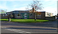
Trowbridge Fire Station
Part of Wiltshire Fire & Rescue Service, located on Hilperton Road (A361) next door to the ambulance station. http://www.geograph.org.uk/photo/2720822
Image: © Jaggery
Taken: 5 Dec 2011
0.15 miles
10
Trowbridge Ambulance Station
Located on Hilperton Road (A361) alongside the fire station. http://www.geograph.org.uk/photo/2720811
This is one of many ambulance stations operated by Great Western Ambulance Trust, an NHS (National Health Service) trust.
Image: © Jaggery
Taken: 5 Dec 2011
0.15 miles