IMAGES TAKEN NEAR TO
Montague Court, TROWBRIDGE, BA14 7HX
Introduction
This page details the photographs taken nearby to Montague Court, BA14 7HX by members of the Geograph project.
The Geograph project started in 2005 with the aim of publishing, organising and preserving representative images for every square kilometre of Great Britain, Ireland and the Isle of Man.

There are currently over 7.5m images from over14,400 individuals and you can help contribute to the project by visiting https://www.geograph.org.uk
Image Map
Images are licensed for reuse under creativecommons.org/licenses/by-sa/2.0
Notes
- Clicking on the map will re-center to the selected point.
- The higher the marker number, the further away the image location is from the centre of the postcode.
Image Listing (7 Images Found)
Images are licensed for reuse under creativecommons.org/licenses/by-sa/2.0
Image
Details
Distance
1
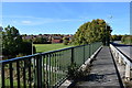
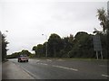
Bridge over Paxcroft Brook
Leap Gate passes over Paxcroft Brook and green space, in the eastern part of Trowbridge. It is in the middle of a large new housing development.
Image: © Julian P Guffogg
Taken: 29 Sep 2018
0.06 miles
2
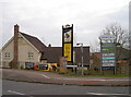
The Red Admiral
As the Paxcroft Mead area is a fairly new estate provision has been made to include a welcoming family pub. A small retail park is just behind it.
Image: © Neil Owen
Taken: 29 Feb 2012
0.10 miles

4
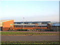
The Mead County Primary school
Looking east at the Mead County Primary school, serving the Paxcroft Mead development near Trowbridge.
Image: © Phil Williams
Taken: 11 Dec 2005
0.21 miles
7
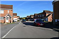
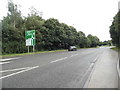
Cornbrash Rise, Trowbridge
A slightly more mature area of this large housing development.
Image: © Julian P Guffogg
Taken: 29 Sep 2018
0.25 miles