IMAGES TAKEN NEAR TO
Clarendon Avenue, TROWBRIDGE, BA14 7BW
Introduction
This page details the photographs taken nearby to Clarendon Avenue, BA14 7BW by members of the Geograph project.
The Geograph project started in 2005 with the aim of publishing, organising and preserving representative images for every square kilometre of Great Britain, Ireland and the Isle of Man.

There are currently over 7.5m images from over14,400 individuals and you can help contribute to the project by visiting https://www.geograph.org.uk
Image Map
Images are licensed for reuse under creativecommons.org/licenses/by-sa/2.0
Notes
- Clicking on the map will re-center to the selected point.
- The higher the marker number, the further away the image location is from the centre of the postcode.
Image Listing (55 Images Found)
Images are licensed for reuse under creativecommons.org/licenses/by-sa/2.0
Image
Details
Distance
1
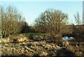
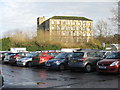
Biss Meadows Country Park, Trowbridge
Being floodplain most developers have left this area alone and it has now become a small but pleasant oasis for those living in the new developments around it. That is, if one can ignore the dumped trolleys, carrier bags and other wrapping litter, for immediately behind the photographer is the Tesco's car park with recycling facility.
Image: © Alan Cooper
Taken: Unknown
0.06 miles
2
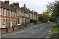
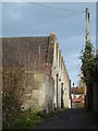
2007 : West Ashton Road
Trowbridge is a curate's egg of a town, this is one of the good bits. It is not all like this. For the other side of the coin see Image]
Image: © Maurice Pullin
Taken: 16 Oct 2007
0.07 miles
3
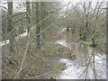
The River Biss at Trowbridge
Looking upstream towards the Biss Meadows Country Park.
Image: © M J Richardson
Taken: 24 Dec 2015
0.08 miles
4
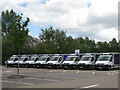
Home delivery vans parked at the back of the supermarket carpark
Image: © Sarah Charlesworth
Taken: 16 Jun 2011
0.09 miles
5
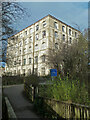
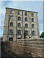
Ashton Mills, Trowbridge
Five storey stone mill with adjoining stone built weaving sheds and a brick engine house. Dates from 1860 and in the textile trade until 1963.
Image: © Chris Allen
Taken: 8 Jan 2012
0.10 miles
6
Ashton Mills, Trowbridge
Five storey stone mill with adjoining stone built weaving sheds and a brick engine house. Dates from 1860 and in the textile trade until 1963. This view shows the five storey block that is Grade II Listed.
Image: © Chris Allen
Taken: 8 Jan 2012
0.10 miles
7
Ashton Mills, Trowbridge
The stone built single storey, north-light weaving sheds.
Image: © Chris Allen
Taken: 8 Jan 2012
0.10 miles
8
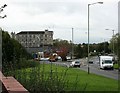
2007 : The Inner Ring Road (unfinished)
Trowbridge as a town was always functional rather than pretty, but it once had a certain charm. The uglification process began in the 1950's and is now well under way. This is the inner ring road, less than one third of it has been completed. Tesco's Super Store is off to the right and one of the old woollen mills is on the left.
Image: © Maurice Pullin
Taken: 16 Oct 2007
0.11 miles
9
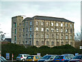
Ashton Mills, Trowbridge
Five storey stone mill with adjoining stone built weaving sheds and a brick engine house. Dates from 1860 and in the textile trade until 1963. The five storey block is Grade II Listed.
Image: © Chris Allen
Taken: 8 Jan 2012
0.11 miles
10
Ashton Mills, Trowbridge
A large mill, originally a woollen mill, seen from across the River Biss.
Image: © M J Richardson
Taken: 24 Dec 2015
0.11 miles