IMAGES TAKEN NEAR TO
School Lane, TROWBRIDGE, BA14 6NZ
Introduction
This page details the photographs taken nearby to School Lane, BA14 6NZ by members of the Geograph project.
The Geograph project started in 2005 with the aim of publishing, organising and preserving representative images for every square kilometre of Great Britain, Ireland and the Isle of Man.

There are currently over 7.5m images from over14,400 individuals and you can help contribute to the project by visiting https://www.geograph.org.uk
Image Map
Images are licensed for reuse under creativecommons.org/licenses/by-sa/2.0
Notes
- Clicking on the map will re-center to the selected point.
- The higher the marker number, the further away the image location is from the centre of the postcode.
Image Listing (15 Images Found)
Images are licensed for reuse under creativecommons.org/licenses/by-sa/2.0
Image
Details
Distance
1

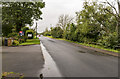
Branch Line
Seen from the railway bridge at Staverton looking south. The next station is at Trowbridge. This line joins the main Bath/Bradford on Avon/Trowbridge/etc
line a very short distance beyond the bend.
Image: © Maurice Pullin
Taken: 3 Nov 2007
0.06 miles
2

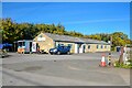
Emmaus school, Staverton
An independent school, with a modern extension to the older building.
Image: © Neil Owen
Taken: 16 Aug 2021
0.11 miles
4

Benchmark on Hilperton Overbridge
The railways came to Hilperton with a passion in the Victorian era and several rival firms had to meet to negotiate the flood plains around the River Avon. This bridge also carries a benchmark of about the same vintage - see https://www.bench-marks.org.uk/bm71702 for the entry in the Benchmark Database and Image] for a wider view of this otherwise unremarkable road bridge.
Image: © Neil Owen
Taken: 16 Aug 2021
0.14 miles
5

Hilperton overbridge
Beneath are the G.W.R. lines. This part of the world is where a number of railway lines meet and negotiate the lowlands around the River Avon. In times past there were the Bathampton and Bradford, the Wiltshire, Somerset and Weymouth, and also the Berks & Hants extension lines that crossed each other.
On the south (left) parapet is a benchmark - see Image
Image: © Neil Owen
Taken: 16 Aug 2021
0.15 miles
7
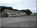
Staverton Club
The club is a non-profit social and recreational club, aiming to provide food and community facilities. Having been closed during lockdown, the club is seeking to make up for lost revenue.
Image: © Neil Owen
Taken: 16 Aug 2021
0.15 miles
8
Staverton : Staverton Social Club
Social club seen off New Terrace.
Image: © Lewis Clarke
Taken: 18 Oct 2022
0.15 miles
9
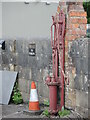
Water pump in a yard near Staverton
A 'lift and force' pump of a bygone age remains in an open yard near the main road.
Image: © Neil Owen
Taken: 16 Aug 2021
0.19 miles
10
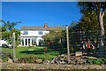
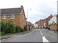
Staverton : Houses
Houses alongside New Terrace.
Image: © Lewis Clarke
Taken: 18 Oct 2022
0.19 miles