IMAGES TAKEN NEAR TO
Martins Lane, TROWBRIDGE, BA14 6NB
Introduction
This page details the photographs taken nearby to Martins Lane, BA14 6NB by members of the Geograph project.
The Geograph project started in 2005 with the aim of publishing, organising and preserving representative images for every square kilometre of Great Britain, Ireland and the Isle of Man.

There are currently over 7.5m images from over14,400 individuals and you can help contribute to the project by visiting https://www.geograph.org.uk
Image Map
Images are licensed for reuse under creativecommons.org/licenses/by-sa/2.0
Notes
- Clicking on the map will re-center to the selected point.
- The higher the marker number, the further away the image location is from the centre of the postcode.
Image Listing (45 Images Found)
Images are licensed for reuse under creativecommons.org/licenses/by-sa/2.0
Image
Details
Distance
1
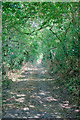
![Martins Lane [2]](https://s3.geograph.org.uk/geophotos/05/60/49/5604943_7fef46b3_120x120.jpg)
Martins Lane [2]
Leading off Martins Road, the lane provides access to several properties before it become unsurfaced and continues as a byway. For the reverse view see Image
Image: © Michael Dibb
Taken: 5 Nov 2017
0.01 miles
2
![Martins Lane [1]](https://s0.geograph.org.uk/geophotos/05/60/49/5604940_34b8ad9e_120x120.jpg)
Martins Lane [1]
Leading off Martins Road, the lane provides access to several properties before it become unsurfaced and continues as a byway. For the reverse view see Image
Image: © Michael Dibb
Taken: 5 Nov 2017
0.05 miles
3
![Keevil houses [8]](https://s3.geograph.org.uk/geophotos/05/60/49/5604939_4805130b_120x120.jpg)
Keevil houses [8]
The village has many old and interesting houses. Forge Cottage has been greatly extended but the left wing is timber framed from circa 1600. The cottage is listed, grade II, with details at: https://www.historicengland.org.uk/listing/the-list/list-entry/1262536
Image: © Michael Dibb
Taken: 5 Nov 2017
0.05 miles
5
![Keevil houses [7]](https://s2.geograph.org.uk/geophotos/05/60/49/5604938_043a0f7d_120x120.jpg)
Keevil houses [7]
The village has many old and interesting houses. Number 67 Martins Road has been extended.
Image: © Michael Dibb
Taken: 5 Nov 2017
0.07 miles
6
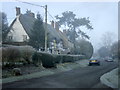
2008 : Frost and mist come to Keevil.
Houses near the end of Martins Lane.
village
Image: © Maurice Pullin
Taken: 7 Dec 2008
0.09 miles
7
![Keevil houses [6]](https://s1.geograph.org.uk/geophotos/05/60/49/5604937_4e3b035e_120x120.jpg)
Keevil houses [6]
The village has many old and interesting houses. Numbers 63, 64 and 65 Martins Road are 17th century and are listed, grade II, with details at: https://www.historicengland.org.uk/listing/the-list/list-entry/1251925
Image: © Michael Dibb
Taken: 5 Nov 2017
0.09 miles
8
![Keevil houses [3]](https://s3.geograph.org.uk/geophotos/05/60/31/5603167_d8ec957d_120x120.jpg)
Keevil houses [3]
The village has many old and interesting houses. Numbers 52 and 53 Martins Road are timber framed row houses built circa 1700. Listed, grade II, with details at: https://www.historicengland.org.uk/listing/the-list/list-entry/1262470 Number 54 (to the right) is also listed for group value with details at: https://www.historicengland.org.uk/listing/the-list/list-entry/1262539
Image: © Michael Dibb
Taken: 5 Nov 2017
0.10 miles
9
![Keevil houses [4]](https://s1.geograph.org.uk/geophotos/05/60/31/5603169_8019a6fb_120x120.jpg)
Keevil houses [4]
The village has many old and interesting houses. Numbers 50 and 51 Martins Road are early 18th century and are listed, grade II, with details at: https://www.historicengland.org.uk/listing/the-list/list-entry/1251923
Image: © Michael Dibb
Taken: 5 Nov 2017
0.10 miles
10
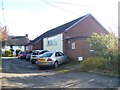
Village hall
The village hall in Keevil was erected in 1963 and replaced an old iron building which dated to 1895.
Image: © Michael Dibb
Taken: 5 Nov 2017
0.11 miles