IMAGES TAKEN NEAR TO
Underacre Close, TROWBRIDGE, BA14 6GH
Introduction
This page details the photographs taken nearby to Underacre Close, BA14 6GH by members of the Geograph project.
The Geograph project started in 2005 with the aim of publishing, organising and preserving representative images for every square kilometre of Great Britain, Ireland and the Isle of Man.

There are currently over 7.5m images from over14,400 individuals and you can help contribute to the project by visiting https://www.geograph.org.uk
Image Map
Images are licensed for reuse under creativecommons.org/licenses/by-sa/2.0
Notes
- Clicking on the map will re-center to the selected point.
- The higher the marker number, the further away the image location is from the centre of the postcode.
Image Listing (4 Images Found)
Images are licensed for reuse under creativecommons.org/licenses/by-sa/2.0
Image
Details
Distance
1
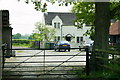
2008 : Green Lane Farm
An idyllic rural scene. Wait till you see what is on the other side of the road.
Image: © Maurice Pullin
Taken: 9 May 2008
0.07 miles
2
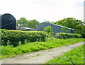
2008 : Outbuildings at Green Lane Farm
This is Green Lane at its best, it is legal to drive along here but not advisable.
Image: © Maurice Pullin
Taken: 9 May 2008
0.10 miles
3
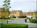
2008 : New housing development near Green Lane Farm
The houses don't look too bad, certainly better than many built during the 1950's to 1980's but this is only the edge of the estate.
Image: © Maurice Pullin
Taken: 9 May 2008
0.13 miles
4
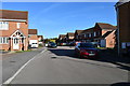
Cornbrash Rise, Trowbridge
A slightly more mature area of this large housing development.
Image: © Julian P Guffogg
Taken: 29 Sep 2018
0.17 miles