IMAGES TAKEN NEAR TO
Partis College, Partis Way, BATH, BA1 3QD
Introduction
This page details the photographs taken nearby to Partis College, Partis Way, BA1 3QD by members of the Geograph project.
The Geograph project started in 2005 with the aim of publishing, organising and preserving representative images for every square kilometre of Great Britain, Ireland and the Isle of Man.

There are currently over 7.5m images from over14,400 individuals and you can help contribute to the project by visiting https://www.geograph.org.uk
Image Map
Images are licensed for reuse under creativecommons.org/licenses/by-sa/2.0
Notes
- Clicking on the map will re-center to the selected point.
- The higher the marker number, the further away the image location is from the centre of the postcode.
Image Listing (26 Images Found)
Images are licensed for reuse under creativecommons.org/licenses/by-sa/2.0
Image
Details
Distance
1
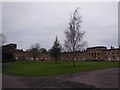
Partis College
Partis College is one of Bath's hidden gems. It is a charity which houses thirty women aged over 50, of professional status but in reduced circumstances (for example Services widows). It is an Anglican foundation; the chapel is behind the pediment. As it is a private organisation and on the fringes of Bath, hidden behind trees and hedges, most Bathonians are probably unaware of it.
Image: © HelenK
Taken: 6 Jan 2013
0.02 miles
2

Partis Way, Bath
Partis Way is a small estate of homogeneous houses built in the early 1960's to the west of the RUH. This picture is dated 1st April 2000, but little has changed in 19 years.
Image: © David Wickham
Taken: 1 Apr 2000
0.06 miles
3
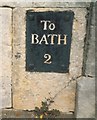
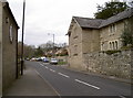
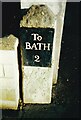
Old Milestone by the A431, Kelston Road, Newbridge
Metal plate attached to stone post by the A431, in parish of BATH (BATH AND NORTH EAST SOMERSET District), Kelston Road, Newbridge, by gate with sign "Access via Partis Way", embedded in good quality stone wall, on North side of road. Bath incised iron plate, erected by the Bath turnpike trust in the 18th century.
Inscription reads:-
TO
BATH
2
Grade II listed.
List Entry Number: 1395938 https://historicengland.org.uk/listing/the-list/list-entry/1395938
Milestone Society National ID: SO_BRBA10.
Image: © JR Dowding
Taken: 4 Aug 2002
0.08 miles
4
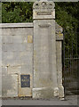
Incorporated in the wall
A milestone on Kelston Road, embedded in the wall adjoining an entrance.
Image: © Neil Owen
Taken: 6 Jan 2012
0.08 miles
5
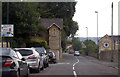
Kelston Road, Bath
The A431 near the hospital.
Image: © J.Hannan-Briggs
Taken: 31 Jul 2014
0.09 miles
6
Kelston Road
Looking westward, this area has not only a cut benchmark but also a Flush Bracket to its name. The cutmark is on the lodge to the right and the FB on the wall to the left. See Image] and Image] respectively.
Image: © Neil Owen
Taken: 6 Jan 2012
0.10 miles
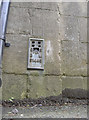
7
Cancelled cut benchmark on Kelston Road
This mark appears to have some downward arrows along with the conventional upward pointing ones. This indicates the mark has subsequently been cancelled - thanks to Roger Templeman for the information. Interestingly it is barely a few metres from a Flush Bracket. See Image] for a location shot and see http://www.bench-marks.org.uk/bm40822 for the Benchmark Database, which gives some more details.
Image: © Neil Owen
Taken: 6 Jan 2012
0.10 miles
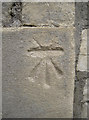
8
Flush Bracket S1446
Located in a wall in Kelston Road, this surveying benchmark was levelled at 47.3m above mean sea level. The next one in the series is located just up the road: Image See the Benchmark Database http://www.bench-marks.org.uk/bm10324 for more details, and Image] for a wider view including details of a cutmark close by.
Image: © Neil Owen
Taken: 6 Jan 2012
0.10 miles
9
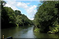
River Avon on the Western fringes of Bath
This section of the river is just to the west of Bath, and flows down to Bristol. Once it would have carried heavy industrial traffic to Bristol, now it really only carries leisure craft.
Photo taken from the boat, looking upstream.
Image: © Martyn Pattison
Taken: 3 Aug 2005
0.16 miles
10
Old Milestone, A4, Newbridge, Bath
By No. 200, Upper Bristol Road, in front of domestic gate post, on pavement. Bath incised iron plate. Alternate views see https://www.geograph.org.uk/photo/5304075 & https://www.geograph.org.uk/photo/2753653 & https://www.geograph.org.uk/photo/6048128 & https://www.geograph.org.uk/photo/2753656
To / Bath / 2
Milestone Society National ID: SO_BABR02
Image: © Janet Dowding
Taken: 4 Aug 2002
0.17 miles