IMAGES TAKEN NEAR TO
Apsley Close, BATH, BA1 3LR
Introduction
This page details the photographs taken nearby to Apsley Close, BA1 3LR by members of the Geograph project.
The Geograph project started in 2005 with the aim of publishing, organising and preserving representative images for every square kilometre of Great Britain, Ireland and the Isle of Man.

There are currently over 7.5m images from over14,400 individuals and you can help contribute to the project by visiting https://www.geograph.org.uk
Image Map
Images are licensed for reuse under creativecommons.org/licenses/by-sa/2.0
Notes
- Clicking on the map will re-center to the selected point.
- The higher the marker number, the further away the image location is from the centre of the postcode.
Image Listing (16 Images Found)
Images are licensed for reuse under creativecommons.org/licenses/by-sa/2.0
Image
Details
Distance
1
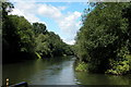
River Avon on the Western fringes of Bath
This section of the river is just to the west of Bath, and flows down to Bristol. Once it would have carried heavy industrial traffic to Bristol, now it really only carries leisure craft.
Photo taken from the boat, looking upstream.
Image: © Martyn Pattison
Taken: 3 Aug 2005
0.07 miles
2

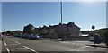
2008 : Newbridge Hill, Lower Weston, Bath
Newbridge Hill carries the A431 out of Bath through Kelston and Bitton to Bristol.
Image: © Maurice Pullin
Taken: 14 Jul 2008
0.07 miles
4

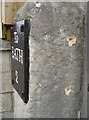
Benchmark on a pillar
This one is listed in the Benchmark Database (http://www.bench-marks.org.uk/bm40823 ) and is in front of the Aquae Sulis hotel (Image]).
Image: © Neil Owen
Taken: 6 Jan 2012
0.14 miles
5

Aquae Sulis Hotel
Located on the A4 Newbridge Road. A benchmark is located on the entrance pillar - see Image
Image: © Neil Owen
Taken: 6 Jan 2012
0.14 miles
6

Partis Way, Bath
Partis Way is a small estate of homogeneous houses built in the early 1960's to the west of the RUH. This picture is dated 1st April 2000, but little has changed in 19 years.
Image: © David Wickham
Taken: 1 Apr 2000
0.18 miles
7
It's a milestone with a benchmark
However, the benchmark's datum cut appears to have been filled in at some point, and judging by the screwholes was also covered over too. See Image] for the face view of the milestone, and http://www.bench-marks.org.uk/bm40824 for the Benchmark Database.
Image: © Neil Owen
Taken: 6 Jan 2012
0.20 miles
8
Not much further to go now
A relic of a bygone age is jostled by more modern structures as it faces onto the Newbridge Road. A benchmark can just about be made out on the stone's side: Image
Image: © Neil Owen
Taken: 6 Jan 2012
0.20 miles
9
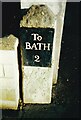
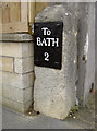
Old Milestone, A4, Newbridge, Bath
By No. 200, Upper Bristol Road, in front of domestic gate post, on pavement. Bath incised iron plate. Alternate views see https://www.geograph.org.uk/photo/5304075 & https://www.geograph.org.uk/photo/2753653 & https://www.geograph.org.uk/photo/6048128 & https://www.geograph.org.uk/photo/2753656
To / Bath / 2
Milestone Society National ID: SO_BABR02
Image: © Janet Dowding
Taken: 4 Aug 2002
0.21 miles
10
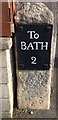
Old Milestone by the A4, Upper Bristol Road, Newbridge, Bath
Milestone with metal plate, on the A4, Bath, Newbridge, by No. 200, Upper Bristol Road, in front of domestic gate post, on pavement. Type: Bath incised plate, erected by the Bath Turnpike Trust, C18.
Inscription reads:- : To / BATH / 2 :
Milestone Society National ID: SO_BABR02.
Image: © Milestone Society
Taken: 7 Mar 2017
0.21 miles