IMAGES TAKEN NEAR TO
Newbridge Road, BATH, BA1 3JX
Introduction
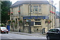
This page details the photographs taken nearby to Newbridge Road, BA1 3JX by members of the Geograph project.
The Geograph project started in 2005 with the aim of publishing, organising and preserving representative images for every square kilometre of Great Britain, Ireland and the Isle of Man.

There are currently over 7.5m images from over14,400 individuals and you can help contribute to the project by visiting https://www.geograph.org.uk
Image Map
Images are licensed for reuse under creativecommons.org/licenses/by-sa/2.0
Notes
- Clicking on the map will re-center to the selected point.
- The higher the marker number, the further away the image location is from the centre of the postcode.
Image Listing (64 Images Found)
Images are licensed for reuse under creativecommons.org/licenses/by-sa/2.0
Image
Details
Distance
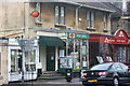
1
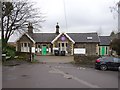
Post Office in Twerton on A4
The road at the side is Station Road, which led to Weston (Bath) railway station, closed in 1953
Image: © David Smith
Taken: 10 Jun 2017
0.04 miles
2
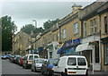
2008 : Row of shops in Chelsea Road, Lower Weston, Bath
Image: © Maurice Pullin
Taken: 14 Jul 2008
0.04 miles
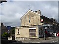
3
The Weston Inn
Sad to see yet another closed pub with a to let sign on the front. This building is Grade II https://historicengland.org.uk/listing/the-list/list-entry/1405772 listed and was built around 1890.
Image: © Philip Halling
Taken: 17 May 2021
0.06 miles
4
2008 : Newbridge Road Post Office
And other businesses.
On the corner of Station Road, between Lower Weston and Locksbrook.
Image: © Maurice Pullin
Taken: 14 Jul 2008
0.07 miles
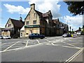
5
2008 : New Crown, Lower Weston, Bath
At the junction of Newbridge Hill and Chelsea Road.
http://www.thenewcrowninn.co.uk/
Image: © Maurice Pullin
Taken: 14 Jul 2008
0.07 miles
6
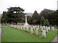
We will remember them
Part of Locksbrook cemetery is held for those lost whilst in the services, from both world wars and beside.
Image: © Neil Owen
Taken: 6 Jan 2012
0.08 miles
7
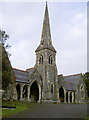
Locksbrook Cemetery chapel
Locksbrook Cemetery is an inner-city oasis of calm despite being a short distance from a major road and the centre of Bath. The chapel is located in the middle of the grounds, and has a benchmark on it - see Image
Image: © Neil Owen
Taken: 6 Jan 2012
0.09 miles
8
Weston (Bath) railway station (site), Somerset
Opened in 1869 as Weston by the Midland Railway on the line from Bristol to Bath Green Park via Mangotsfield, this station was renamed Weston (Bath) in 1934. It closed to passengers in 1953 and completely in 1965.
View south at the forecourt.
Image: © Nigel Thompson
Taken: 31 Mar 2018
0.09 miles
9
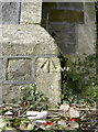
Benchmark on the chapel, Locksbrook
A cut benchmark on the east corner of the mortuary chapel in Locksbrook cemetery. For details of it and more nearby see http://www.bench-marks.org.uk/bm40833. For a wider view take a look at http://www.geograph.org.uk/photo/2754119 or Image
Image: © Neil Owen
Taken: 6 Jan 2012
0.11 miles
10
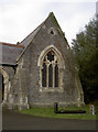
Eastern corner of Locksbrook Cemetery chapel
The chapel has a double archway and this eastern wing has a benchmark. See Image] for the wider view and Image] for the benchmark.
Image: © Neil Owen
Taken: 6 Jan 2012
0.11 miles