IMAGES TAKEN NEAR TO
Locksbrook Road, BATH, BA1 3EL
Introduction
This page details the photographs taken nearby to Locksbrook Road, BA1 3EL by members of the Geograph project.
The Geograph project started in 2005 with the aim of publishing, organising and preserving representative images for every square kilometre of Great Britain, Ireland and the Isle of Man.

There are currently over 7.5m images from over14,400 individuals and you can help contribute to the project by visiting https://www.geograph.org.uk
Image Map
Images are licensed for reuse under creativecommons.org/licenses/by-sa/2.0
Notes
- Clicking on the map will re-center to the selected point.
- The higher the marker number, the further away the image location is from the centre of the postcode.
Image Listing (100 Images Found)
Images are licensed for reuse under creativecommons.org/licenses/by-sa/2.0
Image
Details
Distance
1

Decorated site boundary
Seen from the footpath alongside the River Avon are these boards around the construction site which are decorated with images of machines. Behind the boards work is going on to convert the Herman Miller factory into the new Bath Spa University School of Art and Design.
Image: © Michael Dibb
Taken: 2 Jun 2018
0.02 miles
2
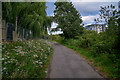
Bath : Bath Bristol Cycle Track
A track heads alongside the river.
Image: © Lewis Clarke
Taken: 6 Aug 2020
0.03 miles
3
River Avon in Locksbrook
On the left is the riverside cycle route (NCN4)
Image: © David Smith
Taken: 7 Jul 2016
0.04 miles
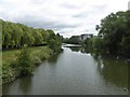
4
Bath : The River Avon
Looking along the River Avon.
Image: © Lewis Clarke
Taken: 6 Aug 2020
0.04 miles
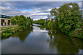
5
![Gently flows the Avon [2]](https://s3.geograph.org.uk/geophotos/05/81/15/5811511_1cf3ecde_120x120.jpg)
Gently flows the Avon [2]
The River Avon looking upstream from the footbridge.
Image: © Michael Dibb
Taken: 2 Jun 2018
0.04 miles
6
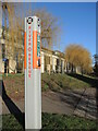
River Rescue post
One of several along this open stretch of the Avon, it provides rescue equipment and contact. It stands in front of Bath Spa University's Locksbrook campus.
Image: © Neil Owen
Taken: 20 Jan 2023
0.05 miles
7
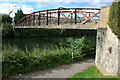
Fielding's Road Bridge, over the River Avon
Footbridge over the River Avon between Locksbrook and Twerton.
Image: © Philip Halling
Taken: 1 Sep 2007
0.05 miles
8

Halfpenny Bridge, River Avon, Bath
A footbridge between Twerton and Locksbrook above Weston Cut, possibly named after the fare of a former ferry. View downstream.
Image: © Pierre Terre
Taken: 20 May 2006
0.06 miles
9
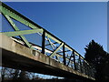
Fieldings Road footbridge
In the past there was the Royal Old Ferry to take people across the Avon. This footbridge replaced it and was only accessible by paying a fee at the toll house on the far side. It is not in use these days.
Image: © Neil Owen
Taken: 20 Jan 2023
0.06 miles
10
![River footbridge [1]](https://s2.geograph.org.uk/geophotos/05/81/15/5811506_1c9fdef7_120x120.jpg)
River footbridge [1]
Seen from the path on the north bank of the River Avon is this footbridge which leads to Fielding's Road.
Image: © Michael Dibb
Taken: 2 Jun 2018
0.06 miles