IMAGES TAKEN NEAR TO
Reeves Piece, WESTBURY, BA13 4TH
Introduction
This page details the photographs taken nearby to Reeves Piece, BA13 4TH by members of the Geograph project.
The Geograph project started in 2005 with the aim of publishing, organising and preserving representative images for every square kilometre of Great Britain, Ireland and the Isle of Man.

There are currently over 7.5m images from over14,400 individuals and you can help contribute to the project by visiting https://www.geograph.org.uk
Image Map
Images are licensed for reuse under creativecommons.org/licenses/by-sa/2.0
Notes
- Clicking on the map will re-center to the selected point.
- The higher the marker number, the further away the image location is from the centre of the postcode.
Image Listing (150 Images Found)
Images are licensed for reuse under creativecommons.org/licenses/by-sa/2.0
Image
Details
Distance
1
![Bratton houses [20]](https://s3.geograph.org.uk/geophotos/06/48/74/6487479_854cdc89_120x120.jpg)
Bratton houses [20]
This fine detached house is named The Butts and is located in the road of the same name. Built circa 1830 in brick with a 20th century rear extension. Listed, grade II, with details at: https://historicengland.org.uk/listing/the-list/list-entry/1364307
Bratton is a former agricultural village which lies on the ‘springline’ of the northern escarpment of Salisbury Plain about 2½ miles east of the town of Westbury. Large flocks of sheep were pastured on the Downs south of the village and corn was grown on the flat lands to the north. The village was the home of the renowned firm of R & J Reeves who produced agricultural machinery.
Image: © Michael Dibb
Taken: 21 Apr 2020
0.06 miles
2
![Bratton houses [19]](https://s1.geograph.org.uk/geophotos/06/48/74/6487477_ce8b7b72_120x120.jpg)
Bratton houses [19]
The Coach House in the road named The Butts is probably the coach house to the house named The Butts.
Bratton is a former agricultural village which lies on the ‘springline’ of the northern escarpment of Salisbury Plain about 2½ miles east of the town of Westbury. Large flocks of sheep were pastured on the Downs south of the village and corn was grown on the flat lands to the north. The village was the home of the renowned firm of R & J Reeves who produced agricultural machinery.
Image: © Michael Dibb
Taken: 21 Apr 2020
0.06 miles
3
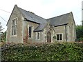
The Oratory, Bratton
Nestled in the north east corner of what was once the vicarage garden the house now known as The Oratory was once The National School. It was built in 1820 with a grant from the National Society. It had flagged floors and loose desks and catered for 20 children. Children were admitted from an early age – some only two years old. There is on record one child who attended the school at the tender age of one year eight months. They usually left school at 12.
This school was in use until 1928 when the new Council School was built.
Image: © Penny Mayes
Taken: 17 Oct 2015
0.06 miles
4
![Bratton houses [18]](https://s0.geograph.org.uk/geophotos/06/48/74/6487476_33c65a82_120x120.jpg)
Bratton houses [18]
Now a private house known as The Oratory this was the National School. Built in 1820 and enlarged in 1877 it served as a school until 1928 when the pupils were moved to the recently built council school.
Bratton is a former agricultural village which lies on the ‘springline’ of the northern escarpment of Salisbury Plain about 2½ miles east of the town of Westbury. Large flocks of sheep were pastured on the Downs south of the village and corn was grown on the flat lands to the north. The village was the home of the renowned firm of R & J Reeves who produced agricultural machinery.
Image: © Michael Dibb
Taken: 21 Apr 2020
0.07 miles
5
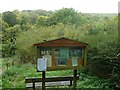
Entrance to Reeves Orchard, Bratton
On the north side of the combe is a community orchard containing several varieties of apple trees, many of which are marked by the name of the variety, the name of who planted it and the date of planting. When I first saw this notice board I assumed it was a recent community venture but the earliest dates I noticed were in the 1930s.
The land was owned by the Reeves family who ran the ironworks and foundry in Bratton. The allotments on the upper slope are made on the bases of the hothouses that supplied the family with out of season fruits and vegetables. The pump house and pumps that drew water from the stream to supply the hothouses, are situated in the orchard but are not open to the public.
In 1936 a mixed orchard of 146 trees was planted. There are a number of different varieties of apples, including: Green Bramley, Ellisons Orange, Laxton's Superb, Newton Wonder, Scarlet Bramley, Charles Ross, Peacemaker, Cox's Orange Pippin, James Grieve and Heron Pippin, and several varieties of Damson trees.
The orchard was gifted to the village in 1988, and lay dormant and heavily overgrown for some years prior to the Parish Council's Conservation Management Plan in 1998.
More details of their planned management of the area here http://web.archive.org/web/20150504205740/http://www.brattonvillage.co.uk/localhistory-Reeves_Community_Orchard_Project_Bratton.htm
Image: © Penny Mayes
Taken: 17 Oct 2015
0.07 miles
6
![Bratton features [3]](https://s0.geograph.org.uk/geophotos/06/48/61/6486144_80618d95_120x120.jpg)
Bratton features [3]
More whimsy alongside the stream in Church Road.
Bratton is a former agricultural village which lies on the ‘springline’ of the northern escarpment of Salisbury Plain about 2½ miles east of the town of Westbury. Large flocks of sheep were pastured on the Downs south of the village and corn was grown on the flat lands to the north. The village was the home of the renowned firm of R & J Reeves who produced agricultural machinery.
Image: © Michael Dibb
Taken: 21 Apr 2020
0.08 miles
7
![Bratton features [2]](https://s2.geograph.org.uk/geophotos/06/48/61/6486142_6990e421_120x120.jpg)
Bratton features [2]
Some mobiles have been built in the steam which flows alongside Church Road.
Bratton is a former agricultural village which lies on the ‘springline’ of the northern escarpment of Salisbury Plain about 2½ miles east of the town of Westbury. Large flocks of sheep were pastured on the Downs south of the village and corn was grown on the flat lands to the north. The village was the home of the renowned firm of R & J Reeves who produced agricultural machinery.
Image: © Michael Dibb
Taken: 21 Apr 2020
0.09 miles
8
![Bratton ways [8]](https://s0.geograph.org.uk/geophotos/06/48/61/6486152_518f5137_120x120.jpg)
Bratton ways [8]
The track leaving Church Road is a public bridleway leading to Longcombe Bottom and then up to meet the Imber Range Perimeter Path on the edge of Salisbury Plain.
Bratton is a former agricultural village which lies on the ‘springline’ of the northern escarpment of Salisbury Plain about 2½ miles east of the town of Westbury. Large flocks of sheep were pastured on the Downs south of the village and corn was grown on the flat lands to the north. The village was the home of the renowned firm of R & J Reeves who produced agricultural machinery.
Image: © Michael Dibb
Taken: 21 Apr 2020
0.09 miles
9
![Bratton ways [7]](https://s2.geograph.org.uk/geophotos/06/48/61/6486114_2f392f3b_120x120.jpg)
Bratton ways [7]
Drivers are advised to ignore their satnav systems and not enter Millditch which soon becomes little more than a footpath.
Bratton is a former agricultural village which lies on the ‘springline’ of the northern escarpment of Salisbury Plain about 2½ miles east of the town of Westbury. Large flocks of sheep were pastured on the Downs south of the village and corn was grown on the flat lands to the north. The village was the home of the renowned firm of R & J Reeves who produced agricultural machinery.
Image: © Michael Dibb
Taken: 21 Apr 2020
0.12 miles
10
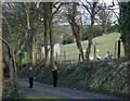
2010 : Geese and goose watchers near Bratton Church
Too late for Christmas,could book one for Easter.
Image: © Maurice Pullin
Taken: 21 Feb 2010
0.12 miles