IMAGES TAKEN NEAR TO
Carpenters Lane, WESTBURY, BA13 4SS
Introduction
This page details the photographs taken nearby to Carpenters Lane, BA13 4SS by members of the Geograph project.
The Geograph project started in 2005 with the aim of publishing, organising and preserving representative images for every square kilometre of Great Britain, Ireland and the Isle of Man.

There are currently over 7.5m images from over14,400 individuals and you can help contribute to the project by visiting https://www.geograph.org.uk
Image Map
Images are licensed for reuse under creativecommons.org/licenses/by-sa/2.0
Notes
- Clicking on the map will re-center to the selected point.
- The higher the marker number, the further away the image location is from the centre of the postcode.
Image Listing (91 Images Found)
Images are licensed for reuse under creativecommons.org/licenses/by-sa/2.0
Image
Details
Distance
1
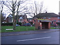
Melbourne Street, Bratton
A view looking to the southwest across the B3098 towards the bus shelter on Melbourne Street.
Image: © Phil Williams
Taken: 16 Jan 2007
0.02 miles
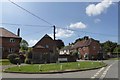
2
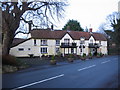
The Duke, Bratton
A view looking to the northeast across the B3098 Melbourne Street towards The Duke public house.
Image: © Phil Williams
Taken: 16 Jan 2007
0.02 miles
3
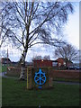
Ironworks memorial
A view looking to the northwest towards Bratton playing field, showing the memorial to the Bratton Iron Works. The car park of The Duke public house can be seen at right.
Image: © Phil Williams
Taken: 16 Jan 2007
0.02 miles
4
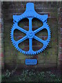
Bratton Iron Works memorial
A detail view of the memorial to the Bratton Iron works, on the B3098 near The Duke public house.
Image: © Phil Williams
Taken: 16 Jan 2007
0.02 miles
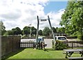
5
![A walk from Edington to the Plain and return [69]](https://s2.geograph.org.uk/geophotos/06/49/46/6494658_e0b814c1_120x120.jpg)
A walk from Edington to the Plain and return [69]
A fine view from the track near the top of Edington Hill. Luccombe Bottom is directly below, then comes the flank of Picquet Hill with the village of Bratton behind. The former cement factory is in the centre of the image.
From the priory church in Edington the walk leaves the village by way of Salisbury Hollow, a byway, and ascends Coulston Hill. The route joins the long distance White Horse Trail to pass over Tinhead Hill on a byway to Tenantry Down. Then an ascent of Edington Hill on a footpath before dropping steeply down Picquet Hill on another footpath to return to the start via Sandy Lane.
Image: © Michael Dibb
Taken: 24 Apr 2020
0.02 miles
7
Bratton, Jubilee Hall
On Melbourne Street; the original building, left, dated 1887, and the extension, right, 2002. https://www.brattonjubileehall.info/
Image: © Mike Faherty
Taken: 20 Jul 2017
0.07 miles
8
Bratton, arch
A whalebone arch at the entrance to the garden of Image, formerly to their tea room; dating from early C20.
Image: © Mike Faherty
Taken: 20 Jul 2017
0.07 miles
9
![Bratton buildings [1]](https://s3.geograph.org.uk/geophotos/06/48/74/6487483_2a837ced_120x120.jpg)
Bratton buildings [1]
The Church Institute Hall in Tynings Lane is one of three buildings (the others are the Jubilee Hall and The Pavilion) in the village available for community and group use as well as for private hire.
Bratton is a former agricultural village which lies on the ‘springline’ of the northern escarpment of Salisbury Plain about 2½ miles east of the town of Westbury. Large flocks of sheep were pastured on the Downs south of the village and corn was grown on the flat lands to the north. The village was the home of the renowned firm of R & J Reeves who produced agricultural machinery.
Image: © Michael Dibb
Taken: 21 Apr 2020
0.08 miles
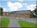
10
![Bratton buildings [6]](https://s0.geograph.org.uk/geophotos/06/48/86/6488604_e66fb977_120x120.jpg)
Bratton buildings [6]
Bratton Primary School was first opened in 1928 to replace the National School (now a private dwelling - see Image). In the late 1970s and early 1980s mobile classrooms were required to accommodate the larger number of pupils and the school was extended in 1982.
Bratton is a former agricultural village which lies on the ‘springline’ of the northern escarpment of Salisbury Plain about 2½ miles east of the town of Westbury. Large flocks of sheep were pastured on the Downs south of the village and corn was grown on the flat lands to the north. The village was the home of the renowned firm of R & J Reeves who produced agricultural machinery.
Image: © Michael Dibb
Taken: 21 Apr 2020
0.08 miles