IMAGES TAKEN NEAR TO
Melbourne Street, WESTBURY, BA13 4RN
Introduction
This page details the photographs taken nearby to Melbourne Street, BA13 4RN by members of the Geograph project.
The Geograph project started in 2005 with the aim of publishing, organising and preserving representative images for every square kilometre of Great Britain, Ireland and the Isle of Man.

There are currently over 7.5m images from over14,400 individuals and you can help contribute to the project by visiting https://www.geograph.org.uk
Image Map (Loading...)


Getting Data...Please wait
Leaflet Map data © OpenStreetMap
Images are licensed for reuse under creativecommons.org/licenses/by-sa/2.0
Notes
- Clicking on the map will re-center to the selected point.
- The higher the marker number, the further away the image location is from the centre of the postcode.
Image Listing (62 Images Found)
Images are licensed for reuse under creativecommons.org/licenses/by-sa/2.0
Image
Details
Distance
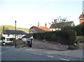
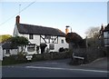
2
![Bratton houses [23]](https://s3.geograph.org.uk/geophotos/06/48/85/6488599_76e8a1db_120x120.jpg)
Bratton houses [23]
Number 5 Melbourne Street and the entrance to Reeves Farm.
Bratton is a former agricultural village which lies on the ‘springline’ of the northern escarpment of Salisbury Plain about 2½ miles east of the town of Westbury. Large flocks of sheep were pastured on the Downs south of the village and corn was grown on the flat lands to the north. The village was the home of the renowned firm of R & J Reeves who produced agricultural machinery.
Image: © Michael Dibb
Taken: 21 Apr 2020
0.01 miles
3
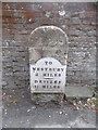
Old Milestone by the B3095, Melbourne Street, Bratton
Metal plate attached to stone post by the B3095, in parish of Bratton (West Wiltshire District), Melbourne Street, by Reeves Farmhouse, in front of wall, on South side of road. Westbury plate, erected by the Westbury Turnpike Trust in the 19th century.
Inscription reads:-
TO
WESTBURY
3 MILES
DEVIZES
11 MILES
Grade II listed. List Entry Number: 1193866
https://historicengland.org.uk/listing/the-list/list-entry/1193866
Milestone Society National ID: WI_DZWY11.
Image: © Milestone Society
Taken: 20 Jul 2017
0.01 miles
4
![Bratton houses [16]](https://s2.geograph.org.uk/geophotos/06/48/60/6486090_f0167797_120x120.jpg)
Bratton houses [16]
Originally two cottages, now one, White Cottage built in brick in the late 17th century has been altered in the mid 19th century. The lean to extension is 20th century. Listed, grade II, with details at: https://historicengland.org.uk/listing/the-list/list-entry/1364275
Bratton is a former agricultural village which lies on the ‘springline’ of the northern escarpment of Salisbury Plain about 2½ miles east of the town of Westbury. Large flocks of sheep were pastured on the Downs south of the village and corn was grown on the flat lands to the north. The village was the home of the renowned firm of R & J Reeves who produced agricultural machinery.
Image: © Michael Dibb
Taken: 21 Apr 2020
0.02 miles
6
![Bratton houses [21]](https://s0.geograph.org.uk/geophotos/06/48/75/6487508_46a79a1e_120x120.jpg)
Bratton houses [21]
This fine detached house was built in 1715, much enlarged in 1826 and altered in 1915 and again in the 1930s. There are many internal features dating from 1826 and the 1930s. Listed, grade II*, with details at: https://historicengland.org.uk/listing/the-list/list-entry/1036520
The wall surrounding the house and the gate piers are listed, grade II, with details at: https://historicengland.org.uk/listing/the-list/list-entry/1036521
Bratton is a former agricultural village which lies on the ‘springline’ of the northern escarpment of Salisbury Plain about 2½ miles east of the town of Westbury. Large flocks of sheep were pastured on the Downs south of the village and corn was grown on the flat lands to the north. The village was the home of the renowned firm of R & J Reeves who produced agricultural machinery.
Image: © Michael Dibb
Taken: 21 Apr 2020
0.03 miles
8
![Bratton houses [22]](https://s1.geograph.org.uk/geophotos/06/48/75/6487521_0aec0679_120x120.jpg)
Bratton houses [22]
Number 1 Melbourne Street is built in rubble stone with timber framing to the rear and with a thatched roof. The left part is dated 1621, the right part was rebuilt in the late 19th century. Listed, grade II, with details at: https://historicengland.org.uk/listing/the-list/list-entry/1364274
Bratton is a former agricultural village which lies on the ‘springline’ of the northern escarpment of Salisbury Plain about 2½ miles east of the town of Westbury. Large flocks of sheep were pastured on the Downs south of the village and corn was grown on the flat lands to the north. The village was the home of the renowned firm of R & J Reeves who produced agricultural machinery.
Image: © Michael Dibb
Taken: 21 Apr 2020
0.03 miles
9
![Bratton houses [15]](https://s0.geograph.org.uk/geophotos/06/48/60/6486084_96b4e1e2_120x120.jpg)
Bratton houses [15]
Originally two cottages, now one, Priory Cottages is late 17th cenyury altered in the mid 19th century. Some original internal features remain. Listed, grade II, with details at: https://historicengland.org.uk/listing/the-list/list-entry/1193880
Bratton is a former agricultural village which lies on the ‘springline’ of the northern escarpment of Salisbury Plain about 2½ miles east of the town of Westbury. Large flocks of sheep were pastured on the Downs south of the village and corn was grown on the flat lands to the north. The village was the home of the renowned firm of R & J Reeves who produced agricultural machinery.
Image: © Michael Dibb
Taken: 21 Apr 2020
0.04 miles
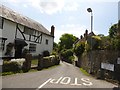
10
Stradbrook at the junction of Melbourne Street
Image: © David Howard
Taken: 5 May 2018
0.04 miles