IMAGES TAKEN NEAR TO
Baynton Way, WESTBURY, BA13 4PT
Introduction
This page details the photographs taken nearby to Baynton Way, BA13 4PT by members of the Geograph project.
The Geograph project started in 2005 with the aim of publishing, organising and preserving representative images for every square kilometre of Great Britain, Ireland and the Isle of Man.

There are currently over 7.5m images from over14,400 individuals and you can help contribute to the project by visiting https://www.geograph.org.uk
Image Map
Images are licensed for reuse under creativecommons.org/licenses/by-sa/2.0
Notes
- Clicking on the map will re-center to the selected point.
- The higher the marker number, the further away the image location is from the centre of the postcode.
Image Listing (49 Images Found)
Images are licensed for reuse under creativecommons.org/licenses/by-sa/2.0
Image
Details
Distance
1
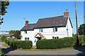
House in Edington
Dwelling near Court Farm.
Image: © Wayland Smith
Taken: 14 Sep 2020
0.02 miles
3
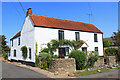
House in Edington
Cottage in the village of Edington.
Image: © Wayland Smith
Taken: 14 Sep 2020
0.07 miles
5
![Edington houses [6]](https://s1.geograph.org.uk/geophotos/06/49/58/6495837_398f9a7a_120x120.jpg)
Edington houses [6]
Shore House is probably late 16th century, timber framed. The house has been altered in the 17th, 18th and 19th centuries and partly rebuilt in brick. The interior is reputed to contain some original features. Listed, grade II, with details at: https://historicengland.org.uk/listing/the-list/list-entry/1021496
The garden wall is late 16th or early 17th century and is listed, grade II, with details at: https://historicengland.org.uk/listing/the-list/list-entry/1181359
Edington is a former agricultural village which lies on the ‘springline’ of the northern escarpment of Salisbury Plain about 4 miles east of the town of Westbury. A priory was founded in the 14th century and became a monastery of the Brothers of Penitence, or Bonshommes. The magnificent monastery church continues in use as the parish church and is the home of the nationally-known annual Edington Music Festival.
Image: © Michael Dibb
Taken: 24 Apr 2020
0.13 miles
6
![Edington houses [15]](https://s3.geograph.org.uk/geophotos/06/51/87/6518743_c4a38724_120x120.jpg)
Edington houses [15]
This attractive thatched house at number 5 Tinhead Road is sited between Tinhead Road and Charlton Hill.
Edington is a former agricultural village which lies on the ‘springline’ of the northern escarpment of Salisbury Plain about 4 miles east of the town of Westbury. A priory was founded in the 14th century and became a monastery of the Brothers of Penitence, or Bonshommes. The magnificent monastery church continues in use as the parish church and is the home of the nationally-known annual Edington Music Festival.
Image: © Michael Dibb
Taken: 24 Apr 2020
0.13 miles
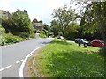
7

Edington, former stable
On Tinhead Road; C18, listed by Historic England. The building appears to be disused, apart from postbox and notice board. http://www.imagesofengland.org.uk/Details/Default.aspx?id=313808&mode=adv
Image: © Mike Faherty
Taken: 27 Aug 2017
0.13 miles
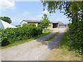
8

2010 : Tinhead Road, Edington
Approaching Court Lane.
In 1610 William Camden had this to say about Edington:
"Neere unto this [Westbury], Eastward lieth "Edinton", in old time "Eathandune", where King Alfred in as memorable a battell as any time else, most fortunatly vanquished the bold, insolent and outragious Danes, and drave them to this hard passe, that they swore in set forme of oath forthwith to depart out of England."
Copied from: http://www.visionofbritain.org.uk/place/place_names.jsp?p_id=11731
Image: © Maurice Pullin
Taken: 5 Mar 2010
0.13 miles
9

2010 : Near the north end of Tinhead Road, Edington
In 1826 William Cobbett mentioned Edington in his "Rural Rides.
"Very near to Bratton Castle (which is only a hill with deep ditches on it) is the village of Eddington, so famed for the battle fought here by Alfred and the Danes. The church in this village would contain several thousands of persons; and the village is reduced to a few straggling houses. The land here is very good; better than almost any I ever saw; as black and, apparently, as rich as the land in the market-gardens at Fulham. The turnips are very good all along here for several miles;"
The above was copied from: http://www.visionofbritain.org.uk/text/chap_page.jsp?t_id=Cobbett&c_id=23&p_id=11731#pn_64
Image: © Maurice Pullin
Taken: 5 Mar 2010
0.13 miles
10
![A walk from Edington to the Plain and return [2]](https://s1.geograph.org.uk/geophotos/06/48/97/6489781_ef54df9c_120x120.jpg)
A walk from Edington to the Plain and return [2]
This footpath runs alongside Tinhead Road to Westbury Road, B3098.
From the priory church in Edington the walk leaves the village by way of Salisbury Hollow, a byway, and ascends Coulston Hill. The route joins the long distance White Horse Trail to pass over Tinhead Hill on a byway to Tenantry Down. Then an ascent of Edington Hill on a footpath before dropping steeply down Picquet Hill on another footpath to return to the start via Sandy Lane.
Image: © Michael Dibb
Taken: 24 Apr 2020
0.13 miles