IMAGES TAKEN NEAR TO
Park Lane, WESTBURY, BA13 4NA
Introduction
This page details the photographs taken nearby to Park Lane, BA13 4NA by members of the Geograph project.
The Geograph project started in 2005 with the aim of publishing, organising and preserving representative images for every square kilometre of Great Britain, Ireland and the Isle of Man.

There are currently over 7.5m images from over14,400 individuals and you can help contribute to the project by visiting https://www.geograph.org.uk
Image Map (Loading...)


Getting Data...Please wait
Leaflet Map data © OpenStreetMap
Images are licensed for reuse under creativecommons.org/licenses/by-sa/2.0
Notes
- Clicking on the map will re-center to the selected point.
- The higher the marker number, the further away the image location is from the centre of the postcode.
Image Listing (5 Images Found)
Images are licensed for reuse under creativecommons.org/licenses/by-sa/2.0
Image
Details
Distance
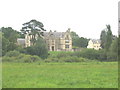
1

Heywood House, Heywood
"Proudly neo-Jacobean" wrote Pevsner. He said it was built c1869, but English Heritage say 1837, which would be very early for such a style. Of limestone, symmetrical with a central oriel window and shaped gables. The free-standing octagonal 'minarets' and square clock tower behind the central gable are "unusual". Grade II* listed.
Now used as offices.
Image: © Stephen Richards
Taken: Unknown
0.01 miles
2
Heywood House, Wiltshire
Until recently, this building housed a regional office of the National Trust. This function has now been transferred to Swindon, and the building is now for sale.
Image: © Phil Williams
Taken: 11 Sep 2005
0.08 miles
3
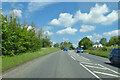
A350 Westbury Road
Towards Trowbridge, although the A350 avoids the town on its way to Melksham.
Image: © Robin Webster
Taken: 30 May 2021
0.23 miles
4
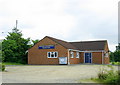
2008 : Heywood and Hawkeridge Village Hall
Just off the A350.
Hawkeridge is about 3/4 mile west.
Image: © Maurice Pullin
Taken: 6 Jun 2008
0.24 miles
5
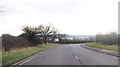
A350 at Heywood
Entrance to Heywood House ahead
Image: © John Firth
Taken: 11 Apr 2013
0.24 miles