IMAGES TAKEN NEAR TO
Victory Road, WESTBURY, BA13 4JL
Introduction
This page details the photographs taken nearby to Victory Road, BA13 4JL by members of the Geograph project.
The Geograph project started in 2005 with the aim of publishing, organising and preserving representative images for every square kilometre of Great Britain, Ireland and the Isle of Man.

There are currently over 7.5m images from over14,400 individuals and you can help contribute to the project by visiting https://www.geograph.org.uk
Image Map
Images are licensed for reuse under creativecommons.org/licenses/by-sa/2.0
Notes
- Clicking on the map will re-center to the selected point.
- The higher the marker number, the further away the image location is from the centre of the postcode.
Image Listing (5 Images Found)
Images are licensed for reuse under creativecommons.org/licenses/by-sa/2.0
Image
Details
Distance
1
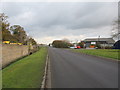
West Wilts. Trading Estate
looking east along Victory Road on the West Wilts. Trading Estate. Behind the wall at left is a vehicle salvage yard.
Image: © Phil Williams
Taken: 26 Nov 2005
0.08 miles
2
![West Wilts Trading Estate [16]](https://s1.geograph.org.uk/geophotos/05/72/66/5726677_b481f578_120x120.jpg)
West Wilts Trading Estate [16]
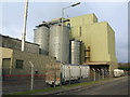
Brook Mill is home to part of the Faccenda Group Ltd, animal feed merchants.
West Wilts Trading Estate is a substantial and long established industrial estate covering some 165 acres. Situated in Westbury an important business centre along the A350 corridor which links the M4 Motorway to the north with the A303 trunk road to the south. The trading estate is home to a wide range of companies.
Image: © Michael Dibb
Taken: 26 Mar 2018
0.08 miles
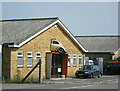
3
Brook Mill, Westbury
This large cereal mill occupies the northwest corner of the West Wilts Trading Estate.
Image: © Phil Williams
Taken: 26 Nov 2005
0.08 miles
4
2008 : Sir, I would have preferred it on the forecourt
A return to the days when traders advertised their calling by hanging a sample of their wares outside the premises.
On a trading estate near Westbury, Wilts
Image: © Maurice Pullin
Taken: 9 Jun 2008
0.21 miles
5
Footpath, Brook Farm
The footpath takes walkers to Storridge Farm.
Image: © Maigheach-gheal
Taken: 19 Apr 2009
0.25 miles