IMAGES TAKEN NEAR TO
Lansdowne Close, WESTBURY, BA13 4JH
Introduction
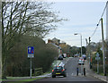
This page details the photographs taken nearby to Lansdowne Close, BA13 4JH by members of the Geograph project.
The Geograph project started in 2005 with the aim of publishing, organising and preserving representative images for every square kilometre of Great Britain, Ireland and the Isle of Man.

There are currently over 7.5m images from over14,400 individuals and you can help contribute to the project by visiting https://www.geograph.org.uk
Image Map (Loading...)


Getting Data...Please wait
Leaflet Map data © OpenStreetMap
Images are licensed for reuse under creativecommons.org/licenses/by-sa/2.0
Notes
- Clicking on the map will re-center to the selected point.
- The higher the marker number, the further away the image location is from the centre of the postcode.
Image Listing (74 Images Found)
Images are licensed for reuse under creativecommons.org/licenses/by-sa/2.0
Image
Details
Distance
1
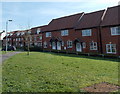
Houses near Lansdowne Close, Dilton Marsh
The car is parked in Lansdowne Close which separates the different styles of houses.
Image: © Jaggery
Taken: 8 Mar 2014
0.01 miles
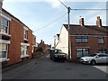
2
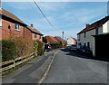
Silver Street, Dilton Marsh
Looking east from the Petticoat Lane end.
Image: © Jaggery
Taken: 8 Mar 2014
0.04 miles
3
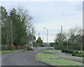
2010 : B3099 leaving Dilton Marsh to the east
On High Street heading for the A3098 near Westbury Leigh.
Image: © Maurice Pullin
Taken: 31 Jan 2010
0.05 miles
4
Petticoat Lane, Dilton Marsh
Looking ESE from near the Whitecroft junction.
Image: © Jaggery
Taken: 8 Mar 2014
0.05 miles
5
2010 : B3099 Dilton Marsh
Traffic calming measures on High Street east of the village.
If the "narrows" don't slow them the speed bumps will.
Image: © Maurice Pullin
Taken: 31 Jan 2010
0.07 miles
6

Fairfield Farm College and Farm Shop, Dilton Marsh
On the north side of High Street.
Image: © Jaggery
Taken: 8 Mar 2014
0.07 miles
7
Old milestone in Dilton Marsh
The milestone on the left is on the north side of the B3099 High Street, near the Friars Close junction.
It shows TO WESTBURY 2 MILES BATH 14 MILES.
Image: © Jaggery
Taken: 8 Mar 2014
0.07 miles
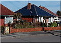
8
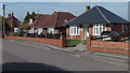
High Street bungalows in Dilton Marsh
A small sample of the houses in the long (c2km) village High Street.
Image: © Jaggery
Taken: 8 Mar 2014
0.07 miles
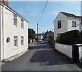
9
Corner of Whitecroft and Petticoat Lane, Dilton Marsh
Viewed from Petticoat Lane which bends to the right past Whitecroft.
Image: © Jaggery
Taken: 8 Mar 2014
0.08 miles
10
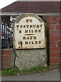
Old Milestone by the B3099, High Street, Dilton Marsh parish
Metal plate attached to stone post by the B3099, in parish of DILTON MARSH (WEST WILTSHIRE District), High Street; Dilton Marsh, forming front gate post/garden wall of No.29, on North side of road. Westbury plate, erected by the Westbury turnpike trust in the 19th century.
Inscription reads:-
TO
WESTBURY
2 MILES
{line}
BATH
14 MILES
Milestone Society National ID: WI_BAWY14.
Image: © JR Dowding
Taken: 1 Jan 2008
0.08 miles