IMAGES TAKEN NEAR TO
Paxmans Road, WESTBURY, BA13 4HS
Introduction
This page details the photographs taken nearby to Paxmans Road, BA13 4HS by members of the Geograph project.
The Geograph project started in 2005 with the aim of publishing, organising and preserving representative images for every square kilometre of Great Britain, Ireland and the Isle of Man.

There are currently over 7.5m images from over14,400 individuals and you can help contribute to the project by visiting https://www.geograph.org.uk
Image Map (Loading...)


Getting Data...Please wait
Leaflet Map data © OpenStreetMap
Images are licensed for reuse under creativecommons.org/licenses/by-sa/2.0
Notes
- Clicking on the map will re-center to the selected point.
- The higher the marker number, the further away the image location is from the centre of the postcode.
Image Listing (61 Images Found)
Images are licensed for reuse under creativecommons.org/licenses/by-sa/2.0
Image
Details
Distance

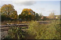
3
Westbury North Junction
Viewed from Station Road bridge. Left for Bristol and Chippenham via Trowbridge.
Right for London via Pewsey. Westbury railway station http://www.geograph.org.uk/photo/3896050 is on the opposite side of the bridge.
Image: © Jaggery
Taken: 8 Mar 2014
0.08 miles
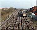
5

Westbury Station
Passenger train approaching Westbury Station.
Image: © Wayland Smith
Taken: 5 Nov 2006
0.11 miles
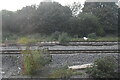
7
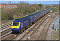
Train arriving at Westbury
First Great Western HST arriving at Westbury.
Image: © Wayland Smith
Taken: 18 Mar 2007
0.14 miles
9
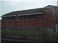
Westbury : Brick Building
This is Westbury Power Signal Box, built by British Railways and opened in May 1984. It replaced a number of mechanical signal boxes, and will itself become redundant sometime in the 2020s decade when its duties are taken over by a new Railway Operating Centre at Didcot.
Image: © Lewis Clarke
Taken: 27 May 2009
0.15 miles
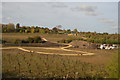
10

The Ham near Westbury
Looking NE along the B3097 The Ham from crossroads beyond the NW boundary of Westbury.
A Spar http://www.geograph.org.uk/photo/3879406 is on the left.
Image: © Jaggery
Taken: 8 Mar 2014
0.16 miles