IMAGES TAKEN NEAR TO
The Ham, WESTBURY, BA13 4HQ
Introduction
This page details the photographs taken nearby to The Ham, BA13 4HQ by members of the Geograph project.
The Geograph project started in 2005 with the aim of publishing, organising and preserving representative images for every square kilometre of Great Britain, Ireland and the Isle of Man.

There are currently over 7.5m images from over14,400 individuals and you can help contribute to the project by visiting https://www.geograph.org.uk
Image Map
Images are licensed for reuse under creativecommons.org/licenses/by-sa/2.0
Notes
- Clicking on the map will re-center to the selected point.
- The higher the marker number, the further away the image location is from the centre of the postcode.
Image Listing (8 Images Found)
Images are licensed for reuse under creativecommons.org/licenses/by-sa/2.0
Image
Details
Distance
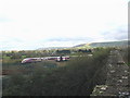
1
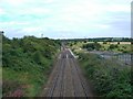
View from Glenmore railway bridge, Westbury
Looking North-east along the Wessex main line between Westbury and Trowbridge, in the distance the tracks deviate to the right, this being the 'chord' to the Penzance to Paddington line.
Image: © Philip Reed
Taken: 4 Aug 2008
0.10 miles
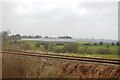
2
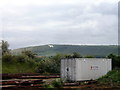
Rails approaching Westbury from the north
With the Westbury White Horse in the distance.
Image: © John Lucas
Taken: 18 May 2002
0.11 miles
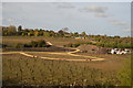
3
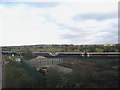
Glenmore junction
Diverted due to weekend engineering works, a twin set Adelante negotiates the chord line at Glenmore junction. It is probably a South Wales to Paddington service, and it is coming off the Bristol-Portsmouth line at left and heading towards Heywood Road junction, where it will take the Hants-Berks line to reading where it will regain its normal path. Heywood House can be seen in the distance at centre, just to the right of the set join.
Image: © Phil Williams
Taken: 13 Nov 2005
0.11 miles
4
Glenmore chord
Looking slightly north of east from the Glenmore bridge over the Bristol-Portsmouth line, a diverted London-bound Adelante unit negotiates the Glenmore chord to Heywood Road Junction to gain the Hants-Berks line to Reading. The Lafarge cement works chimney can be seen slightly left of centre, and the Westbury White Horse can be seen on the edge of the Salisbury Plain just above the end of the second carriage.
Image: © Phil Williams
Taken: 13 Nov 2005
0.11 miles
7
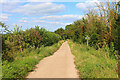
Bridleway near Westbury
Looking north east at the crossing of another footpath.
Image: © Wayland Smith
Taken: 24 Aug 2021
0.22 miles