IMAGES TAKEN NEAR TO
Callum Way, BA13 4FY
Introduction
This page details the photographs taken nearby to Callum Way, BA13 4FY by members of the Geograph project.
The Geograph project started in 2005 with the aim of publishing, organising and preserving representative images for every square kilometre of Great Britain, Ireland and the Isle of Man.

There are currently over 7.5m images from over14,400 individuals and you can help contribute to the project by visiting https://www.geograph.org.uk
Image Map
Images are licensed for reuse under creativecommons.org/licenses/by-sa/2.0
Notes
- Clicking on the map will re-center to the selected point.
- The higher the marker number, the further away the image location is from the centre of the postcode.
Image Listing (55 Images Found)
Images are licensed for reuse under creativecommons.org/licenses/by-sa/2.0
Image
Details
Distance
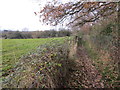
1
Gate on footpath
Public footpath West15 to Penleigh Farm.
Image: © Peter Holmes
Taken: 7 Dec 2013
0.03 miles
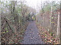
2
Track to Penleigh
Public footpath West15 approaching railway line.
Image: © Peter Holmes
Taken: 7 Dec 2013
0.06 miles
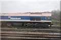
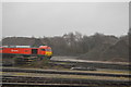
4
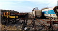
Railway sidings in Westbury
The sidings connect with the main line about 200 metres ahead.
Image: © Jaggery
Taken: 8 Mar 2014
0.10 miles
5
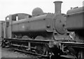
Collett-design '6700' class 0-6-0PT dumped with other withdrawn locomotives at Westbury Depot
The '6700' class was a variant of the '8750's provided with steam brake only and employed only for shunting and freight trips. No. 6771, here minus all number-plates, was built 10/50 and withdrawn 3/58 - a pathetically short working life.
Image: © Ben Brooksbank
Taken: 20 Jul 1963
0.10 miles
6
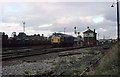
Westbury South Signal Box
Class 45, 45051 stands beside Westbury South Box after delivering a freight (not sure which freight the 6V44 was in 1975). The South Box was one of two signal boxes controlling Westbury - the other being Westbury North Box. The South Box would close at the end of September 1978. The North Box would become just Westbury. The semaphore signals would remain in use until May 1984 when Multi-Aspect Colour Light signalling was introduced on the route, following which both mechanical signal boxes were demolished. The North box can be seen at Image
Image: © Martin Addison
Taken: Unknown
0.11 miles
7
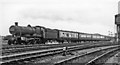
Nottingham - Bournemouth West express leaving Westbury (!)
View NE, towards Westbury station and Bristol via Trowbridge, also London via Newbury: ex-GWR main lines. In previous years this Summer Holiday train ran over the Somerset & Dorset line from Bath, but in 1963, after the Western Region took over and degraded the S&D, the route followed was via Bristol Temple Meads (reverse), Bath Spa, Trowbridge, Westbury and Salisbury - until in 1964 the Salisbury - Bournemouth via Fordingbridge line was closed! This otherwise rather uninteresting photograph is perhaps interesting in that respect. The locomotive is Collett 4-6-0 No. 5986 'Arbury Hall' (built 11/39, withdrawn 9/63).
Image: © Ben Brooksbank
Taken: 20 Jul 1963
0.11 miles
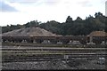
9

Freight handling outside Westbury station
Westbury station retains a large area devoted to freight and good trains.
Image: © David Smith
Taken: 21 May 2011
0.11 miles