IMAGES TAKEN NEAR TO
Sand Pit Lane, WESTBURY, BA13 4FA
Introduction
This page details the photographs taken nearby to Sand Pit Lane, BA13 4FA by members of the Geograph project.
The Geograph project started in 2005 with the aim of publishing, organising and preserving representative images for every square kilometre of Great Britain, Ireland and the Isle of Man.

There are currently over 7.5m images from over14,400 individuals and you can help contribute to the project by visiting https://www.geograph.org.uk
Image Map (Loading...)


Getting Data...Please wait
Leaflet Map data © OpenStreetMap
Images are licensed for reuse under creativecommons.org/licenses/by-sa/2.0
Notes
- Clicking on the map will re-center to the selected point.
- The higher the marker number, the further away the image location is from the centre of the postcode.
Image Listing (4 Images Found)
Images are licensed for reuse under creativecommons.org/licenses/by-sa/2.0
Image
Details
Distance
1
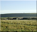
2008 : East toward Old Dilton
Upton Cow Down is on the skyline.
Image: © Maurice Pullin
Taken: 19 Nov 2008
0.15 miles
2
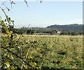
2008 : Rough grazing near Hisomley
Between Hisomley and Upton Scudamore looking west.
The grand house is Dilton Court, Chalcot Park is behind and to the right.
Image: © Maurice Pullin
Taken: 19 Nov 2008
0.20 miles
3
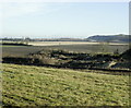
2008 : The Westbury to Portsmouth railway
Is at the bottom of this field with a distant view of the Lafarge Cement Works chimney at Westbury. Image
The Westbury White Horse is not visible being hidden by the northern end of Upton Cow Down and Beggar's Knoll.
Image: © Maurice Pullin
Taken: 19 Nov 2008
0.21 miles
4
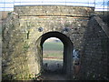
Occupation Crossing
A view looking east through the arch of an occupation crossing down to Biss Bottom. The bridge carries the Bristol-Portsmouth rail line.
Image: © Phil Williams
Taken: 25 Feb 2006
0.24 miles