IMAGES TAKEN NEAR TO
Kingdom Avenue, WESTBURY, BA13 4EW
Introduction
This page details the photographs taken nearby to Kingdom Avenue, BA13 4EW by members of the Geograph project.
The Geograph project started in 2005 with the aim of publishing, organising and preserving representative images for every square kilometre of Great Britain, Ireland and the Isle of Man.

There are currently over 7.5m images from over14,400 individuals and you can help contribute to the project by visiting https://www.geograph.org.uk
Image Map
Images are licensed for reuse under creativecommons.org/licenses/by-sa/2.0
Notes
- Clicking on the map will re-center to the selected point.
- The higher the marker number, the further away the image location is from the centre of the postcode.
Image Listing (32 Images Found)
Images are licensed for reuse under creativecommons.org/licenses/by-sa/2.0
Image
Details
Distance
1
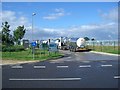
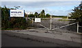
Westbury Dairies delivery entrance
The milk tankers line up at the delivery entrance of Westbury Dairies.
Image: © Philip Reed
Taken: 19 Jul 2008
0.08 miles
2

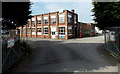
Westbury Dairies main entrance
The main entrance to the Westbury Dairies milk processing plant on the Northacre Industrial Park.
Image: © Philip Reed
Taken: 19 Jul 2008
0.09 miles
3
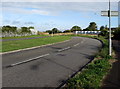
Bend in Stephenson Road, Westbury
Viewed from the corner of Brook Lane.
Image: © Jaggery
Taken: 15 Sep 2018
0.15 miles
4
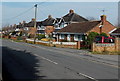
Storridge Road houses near Westbury
Viewed from near crossroads beyond Westbury's NW boundary sign.
Image: © Jaggery
Taken: 8 Mar 2014
0.18 miles
5
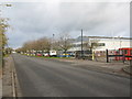
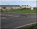
Quartermaster Road, West Wilts. Trading Estate
Looking east along Quartermaster Road on the West Wilts. Trading Estate. The large building is a distribution warehouse for COMET.
Image: © Phil Williams
Taken: 26 Nov 2005
0.19 miles
6
Absolute... The Right Chemistry, Westbury
Locked entrance gates to the Absolute Solvents Limited site viewed across Brook Lane.
Image: © Jaggery
Taken: 15 Sep 2018
0.20 miles
7
ULN (UK) Ltd in Westbury
Packers and wrappers of French cheeses, located in The Ham, Brook Lane, Westbury.
Image: © Jaggery
Taken: 8 Mar 2014
0.20 miles
8
Junction of Brook Lane and Stephenson Road, Westbury
Viewed from the SW end of Brook Lane. Hills Recycling is in the background.
Image: © Jaggery
Taken: 15 Sep 2018
0.20 miles
9
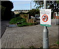
Wiltshire Lorry Watch notice, Brook Lane, Westbury
The Wiltshire Council notice on display in September 2018 states that a Lorry Watch is operating in this area. The scheme is run by Wiltshire Council's Commercial & Consumer Protection to enforce vehicle weight restrictions in the county's towns and parishes. Offenders will be reported - maximum fine £1,000.
Image: © Jaggery
Taken: 15 Sep 2018
0.20 miles
10
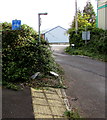
Abrupt end of a cycle route, Brook Lane, Westbury
The End of Cycle Route sign is in a hedge.
Image: © Jaggery
Taken: 15 Sep 2018
0.20 miles