IMAGES TAKEN NEAR TO
High Street, WESTBURY, BA13 4DZ
Introduction
This page details the photographs taken nearby to High Street, BA13 4DZ by members of the Geograph project.
The Geograph project started in 2005 with the aim of publishing, organising and preserving representative images for every square kilometre of Great Britain, Ireland and the Isle of Man.

There are currently over 7.5m images from over14,400 individuals and you can help contribute to the project by visiting https://www.geograph.org.uk
Image Map (Loading...)


Getting Data...Please wait
Leaflet Map data © OpenStreetMap
Images are licensed for reuse under creativecommons.org/licenses/by-sa/2.0
Notes
- Clicking on the map will re-center to the selected point.
- The higher the marker number, the further away the image location is from the centre of the postcode.
Image Listing (19 Images Found)
Images are licensed for reuse under creativecommons.org/licenses/by-sa/2.0
Image
Details
Distance
1
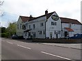
The Prince of Wales, Dilton Marsh
It is believed that an apparition dressed in a long black coat, long boots and a wide brimmed hat walks past this pub on dark winter evenings.
Image: © Maigheach-gheal
Taken: 19 Apr 2009
0.01 miles
2
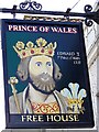
Sign for The Prince of Wales, Dilton Marsh
Edward II (1284-1327) made Prince of Wales 1301 and King from 1307 to 1327. During his reign there was much dissension in the country and at court. He suffered defeat to the Scots at Bannockburn and after a generally unsuccessful reign he was forced to abdicate. He was then brutally mistreated and killed. He was born in Wales and died at Berkeley Castle.
Image: © Maigheach-gheal
Taken: 19 Apr 2009
0.01 miles
3
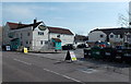
The Prince of Wales, Dilton Marsh
Village pub on the south side of the B3099 High Street. There is a large recycling area on the right.
Image: © Jaggery
Taken: 8 Mar 2014
0.02 miles

5
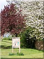
Notice board, Dilton Marsh
The village notice board on an area of green at the western end of the village.
Image: © Maigheach-gheal
Taken: 19 Apr 2009
0.03 miles
6

Street scene, Dilton Marsh
A cat peeps around the corner to see if the coast is clear!
Image: © Maigheach-gheal
Taken: 19 Apr 2009
0.06 miles
7
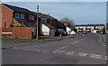
Shepherds Mead, Dilton Marsh
Shepherds Mead is a long cul-de-sac located between the B3099 High Street and Dilton Marsh Farm.
Image: © Jaggery
Taken: 8 Mar 2014
0.07 miles
8
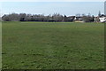
Dilton Marsh Playing Field
Located south of High Street, accessed via Alan Powell Lane, http://www.geograph.org.uk/photo/3958556
this is the home ground of Dilton Rovers FC (football club).
Image: © Jaggery
Taken: 8 Mar 2014
0.08 miles
9

Changing rooms building in Dilton Marsh Playing Field
The metal building is on the east side of the football pitch. http://www.geograph.org.uk/photo/3958576
Image: © Jaggery
Taken: 8 Mar 2014
0.08 miles
10
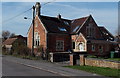
Interesting building in High Street, Dilton Marsh
Viewed from the corner of Alan Powell Lane. The building extends for nearly 20 metres away from the north side of High Street. Now in residential use, it looks like it used to be a church or perhaps a school, but research into its previous usage has been surprisingly fruitless.
Image: © Jaggery
Taken: 8 Mar 2014
0.08 miles