IMAGES TAKEN NEAR TO
Penny Farthing Row, Leigh Close, WESTBURY, BA13 3TP
Introduction
This page details the photographs taken nearby to Penny Farthing Row, Leigh Close, BA13 3TP by members of the Geograph project.
The Geograph project started in 2005 with the aim of publishing, organising and preserving representative images for every square kilometre of Great Britain, Ireland and the Isle of Man.

There are currently over 7.5m images from over14,400 individuals and you can help contribute to the project by visiting https://www.geograph.org.uk
Image Map (Loading...)


Getting Data...Please wait
Leaflet Map data © OpenStreetMap
Images are licensed for reuse under creativecommons.org/licenses/by-sa/2.0
Notes
- Clicking on the map will re-center to the selected point.
- The higher the marker number, the further away the image location is from the centre of the postcode.
Image Listing (44 Images Found)
Images are licensed for reuse under creativecommons.org/licenses/by-sa/2.0
Image
Details
Distance
1
![Westbury houses [6]](https://s1.geograph.org.uk/geophotos/06/80/36/6803633_43fd3d82_120x120.jpg)
Westbury houses [6]
Set back from the road, numbers 29 and 31 Westbury Leigh are a pair of early 19th century 3-storey houses. Built of brick, they have been much altered as many of the windows were originally wider. Listed, grade II, with details at: https://historicengland.org.uk/listing/the-list/list-entry/1364407
Westbury is a former market town in the far west of Wiltshire under the north western edge of Salisbury Plain, 4 miles south of Trowbridge and 4 miles north of Warminster. Westbury was a centre of the cloth industry from the later 15th century until the 19th century. Malting was another important industry. There are now a number of large industrial and trading estates around the town with many residents working there. The town is an important junction point on the railway network with the Reading to Taunton line intersecting the line from Bristol to Southampton.
Westbury Leigh is sometimes considered a separate village, with its own church and chapel, although it is now a contiguous part of the town.
Image: © Michael Dibb
Taken: 9 Feb 2021
0.02 miles
2

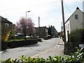
Penny Farthing Row, Westbury Leigh
That's almost poetic!
Image: © Basher Eyre
Taken: 22 Aug 2016
0.02 miles
3
![Westbury houses [7]](https://s0.geograph.org.uk/geophotos/06/80/36/6803636_f36b7a7a_120x120.jpg)
Westbury houses [7]
Numbers 36, 38 and 40 Westbury Leigh are a row of three 18th century cottages. The fenestration is irregular and the cottages have been altered. Listed, grade II, with details at: https://historicengland.org.uk/listing/the-list/list-entry/1364406
Westbury is a former market town in the far west of Wiltshire under the north western edge of Salisbury Plain, 4 miles south of Trowbridge and 4 miles north of Warminster. Westbury was a centre of the cloth industry from the later 15th century until the 19th century. Malting was another important industry. There are now a number of large industrial and trading estates around the town with many residents working there. The town is an important junction point on the railway network with the Reading to Taunton line intersecting the line from Bristol to Southampton.
Westbury Leigh is sometimes considered a separate village, with its own church and chapel, although it is now a contiguous part of the town.
Image: © Michael Dibb
Taken: 9 Feb 2021
0.02 miles
4
![Westbury houses [8]](https://s0.geograph.org.uk/geophotos/06/80/47/6804768_978f8479_120x120.jpg)
Westbury houses [8]
Japonica House, number 42 Westbury Leigh is early 19th century, built in red brick, with later alterations. The shop front that had been inserted in the 20th century has been removed. Listed, grade II, with details at: https://historicengland.org.uk/listing/the-list/list-entry/1036319
Westbury is a former market town in the far west of Wiltshire under the north western edge of Salisbury Plain, 4 miles south of Trowbridge and 4 miles north of Warminster. Westbury was a centre of the cloth industry from the later 15th century until the 19th century. Malting was another important industry. There are now a number of large industrial and trading estates around the town with many residents working there. The town is an important junction point on the railway network with the Reading to Taunton line intersecting the line from Bristol to Southampton.
Westbury Leigh is sometimes considered a separate village, with its own church and chapel, although it is now a contiguous part of the town.
Image: © Michael Dibb
Taken: 9 Feb 2021
0.02 miles
5
![Westbury ways [2]](https://s0.geograph.org.uk/geophotos/06/80/36/6803620_9d7058b4_120x120.jpg)
Westbury ways [2]
From Westbury Leigh, the former A3098, Sparrick Lane leads to Sand Hole Lane and on to Old Dilton Road.
Westbury is a former market town in the far west of Wiltshire under the north western edge of Salisbury Plain, 4 miles south of Trowbridge and 4 miles north of Warminster. Westbury was a centre of the cloth industry from the later 15th century until the 19th century. Malting was another important industry. There are now a number of large industrial and trading estates around the town with many residents working there. The town is an important junction point on the railway network with the Reading to Taunton line intersecting the line from Bristol to Southampton.
Westbury Leigh is sometimes considered a separate village, with its own church and chapel, although it is now a contiguous part of the town.
Image: © Michael Dibb
Taken: 9 Feb 2021
0.03 miles
6
![Westbury houses [10]](https://s0.geograph.org.uk/geophotos/06/80/47/6804776_4edac77d_120x120.jpg)
Westbury houses [10]
Numbers 44 and 46 Westbury Leigh are a pair of 18th century cottages with later alterations and additions. Built in brick, now painted. Number 44 was the post office for some years. Listed, grade II, with details at: https://historicengland.org.uk/listing/the-list/list-entry/1036320
Westbury is a former market town in the far west of Wiltshire under the north western edge of Salisbury Plain, 4 miles south of Trowbridge and 4 miles north of Warminster. Westbury was a centre of the cloth industry from the later 15th century until the 19th century. Malting was another important industry. There are now a number of large industrial and trading estates around the town with many residents working there. The town is an important junction point on the railway network with the Reading to Taunton line intersecting the line from Bristol to Southampton.
Westbury Leigh is sometimes considered a separate village, with its own church and chapel, although it is now a contiguous part of the town.
Image: © Michael Dibb
Taken: 9 Feb 2021
0.03 miles
7
![Westbury houses [9]](https://s2.geograph.org.uk/geophotos/06/80/47/6804770_fa5ac173_120x120.jpg)
Westbury houses [9]
Tuckers Farm, number 43 Westbury Leigh, is early 18th century. Built in brick with two rear extensions. Listed, grade II, with details at: https://historicengland.org.uk/listing/the-list/list-entry/1181499
Westbury is a former market town in the far west of Wiltshire under the north western edge of Salisbury Plain, 4 miles south of Trowbridge and 4 miles north of Warminster. Westbury was a centre of the cloth industry from the later 15th century until the 19th century. Malting was another important industry. There are now a number of large industrial and trading estates around the town with many residents working there. The town is an important junction point on the railway network with the Reading to Taunton line intersecting the line from Bristol to Southampton.
Westbury Leigh is sometimes considered a separate village, with its own church and chapel, although it is now a contiguous part of the town.
Image: © Michael Dibb
Taken: 9 Feb 2021
0.03 miles
8
Westbury Leigh from Holy Saviour Church carpark
Image: © David Gearing
Taken: 9 Apr 2010
0.03 miles
9
![Westbury houses [11]](https://s0.geograph.org.uk/geophotos/06/80/47/6804780_5f426109_120x120.jpg)
Westbury houses [11]
Numbers 47 and 49 Westbury Leigh are a pair of 18th century houses in brick with number 49 pebbledashed. Both houses have gabled extensions at the rear. Listed, grade II, with details at: https://historicengland.org.uk/listing/the-list/list-entry/1036326
Westbury is a former market town in the far west of Wiltshire under the north western edge of Salisbury Plain, 4 miles south of Trowbridge and 4 miles north of Warminster. Westbury was a centre of the cloth industry from the later 15th century until the 19th century. Malting was another important industry. There are now a number of large industrial and trading estates around the town with many residents working there. The town is an important junction point on the railway network with the Reading to Taunton line intersecting the line from Bristol to Southampton.
Westbury Leigh is sometimes considered a separate village, with its own church and chapel, although it is now a contiguous part of the town.
Image: © Michael Dibb
Taken: 9 Feb 2021
0.04 miles
10
![Westbury houses [5]](https://s3.geograph.org.uk/geophotos/06/80/36/6803619_30249133_120x120.jpg)
Westbury houses [5]
The nearest house is number 1 Sparrick Lane, beyond and numbers 23 and 21 Westbury Leigh. The row is 18th century, altered in the 19th century with the gable end to number 1 recently rebuilt. Constructed of brick which has been covered in pebbledash. Listed, grade II, with details at: https://historicengland.org.uk/listing/the-list/list-entry/1036325
Westbury is a former market town in the far west of Wiltshire under the north western edge of Salisbury Plain, 4 miles south of Trowbridge and 4 miles north of Warminster. Westbury was a centre of the cloth industry from the later 15th century until the 19th century. Malting was another important industry. There are now a number of large industrial and trading estates around the town with many residents working there. The town is an important junction point on the railway network with the Reading to Taunton line intersecting the line from Bristol to Southampton.
Westbury Leigh is sometimes considered a separate village, with its own church and chapel, although it is now a contiguous part of the town.
Image: © Michael Dibb
Taken: 9 Feb 2021
0.04 miles