IMAGES TAKEN NEAR TO
Chalford, WESTBURY, BA13 3RT
Introduction
This page details the photographs taken nearby to Chalford, BA13 3RT by members of the Geograph project.
The Geograph project started in 2005 with the aim of publishing, organising and preserving representative images for every square kilometre of Great Britain, Ireland and the Isle of Man.

There are currently over 7.5m images from over14,400 individuals and you can help contribute to the project by visiting https://www.geograph.org.uk
Image Map (Loading...)


Getting Data...Please wait
Leaflet Map data © OpenStreetMap
Images are licensed for reuse under creativecommons.org/licenses/by-sa/2.0
Notes
- Clicking on the map will re-center to the selected point.
- The higher the marker number, the further away the image location is from the centre of the postcode.
Image Listing (7 Images Found)
Images are licensed for reuse under creativecommons.org/licenses/by-sa/2.0
Image
Details
Distance
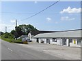
2
Madbrook Farm, Westbury
Looking north along the A350 towards Madbrook Farm on the outskirts of Westbury.
Image: © Phil Williams
Taken: 27 Nov 2005
0.05 miles
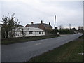
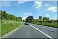
3
A350 on the way into Westbury
The southern outskirts of the Wiltshire town are out of sight round the bend. The road passes through the centre of the town, the residents of which want a bypass. It's a bit of a bottleneck at busy times.
Image: © Brian Robert Marshall
Taken: 13 Sep 2008
0.08 miles
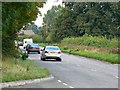
4
A350 south of Westbury
Facing in the direction of Warminster. The viewpoint is a convenient layby.
Image: © Brian Robert Marshall
Taken: 13 Sep 2008
0.15 miles
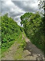
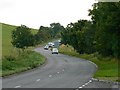
7
2010 : Chalford near Westbury, Wilts
Seen from a footpath near the bottom of Upton Cow Down.
Image: © Maurice Pullin
Taken: 4 Apr 2010
0.24 miles