IMAGES TAKEN NEAR TO
Woodland Industrial Estate, Eden Vale Road, WESTBURY, BA13 3QS
Introduction
This page details the photographs taken nearby to Woodland Industrial Estate, Eden Vale Road, BA13 3QS by members of the Geograph project.
The Geograph project started in 2005 with the aim of publishing, organising and preserving representative images for every square kilometre of Great Britain, Ireland and the Isle of Man.

There are currently over 7.5m images from over14,400 individuals and you can help contribute to the project by visiting https://www.geograph.org.uk
Image Map (Loading...)


Getting Data...Please wait
Leaflet Map data © OpenStreetMap
Images are licensed for reuse under creativecommons.org/licenses/by-sa/2.0
Notes
- Clicking on the map will re-center to the selected point.
- The higher the marker number, the further away the image location is from the centre of the postcode.
Image Listing (30 Images Found)
Images are licensed for reuse under creativecommons.org/licenses/by-sa/2.0
Image
Details
Distance
1
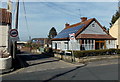
Springfield Road, Westbury
Viewed across the A3098 Leigh Road.
Image: © Jaggery
Taken: 8 Mar 2014
0.12 miles
2
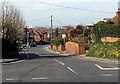
SE end of Eden Vale Road, Westbury
Looking NW from the corner of Leigh Road and Green Lane.
Image: © Jaggery
Taken: 8 Mar 2014
0.13 miles
3

2008 : Leigh Road, Westbury
It doesn't look like it but this is the A3098 going south west to Chapmanslade.
Image: © Maurice Pullin
Taken: 8 Jan 2008
0.14 miles
4

Up the Garden Path .....
This sign at the Eastleigh Surgery on Station Road has always amused me. An unintentional comment on the state of the NHS perhaps?
Image: © Phil Williams
Taken: 6 Feb 2006
0.15 miles
5
![Westbury houses [23]](https://s0.geograph.org.uk/geophotos/06/82/47/6824720_8b132677_120x120.jpg)
Westbury houses [23]
Peppercorn Cottage, number 27 Leigh Road, was built in the late 18th or early 19th century. Constructed of brick with stone quoins with a tiled roof. Listed, grade II, with details at: https://historicengland.org.uk/listing/the-list/list-entry/1036298
Westbury is a former market town in the far west of Wiltshire under the north western edge of Salisbury Plain, 4 miles south of Trowbridge and 4 miles north of Warminster. Westbury was a centre of the cloth industry from the later 15th century until the 19th century. Malting was another important industry. There are now a number of large industrial and trading estates around the town with many residents working there. The town is an important junction point on the railway network with the Reading to Taunton line intersecting the line from Bristol to Southampton.
Image: © Michael Dibb
Taken: 29 Apr 2021
0.15 miles
6

Leigh Road bungalows, Westbury
Located between Springfield Road and Warminster Road.
Image: © Jaggery
Taken: 8 Mar 2014
0.16 miles
7
![Westbury buildings [12]](https://s1.geograph.org.uk/geophotos/06/82/47/6824717_e8f35b08_120x120.jpg)
Westbury buildings [12]
This fine building in Leigh Road is part of the Matravers School complex. Built in coursed rubble stone under a slate roof.
Westbury is a former market town in the far west of Wiltshire under the north western edge of Salisbury Plain, 4 miles south of Trowbridge and 4 miles north of Warminster. Westbury was a centre of the cloth industry from the later 15th century until the 19th century. Malting was another important industry. There are now a number of large industrial and trading estates around the town with many residents working there. The town is an important junction point on the railway network with the Reading to Taunton line intersecting the line from Bristol to Southampton.
Image: © Michael Dibb
Taken: 29 Apr 2021
0.18 miles
8
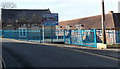
Matravers School, Westbury
Viewed across the A3098 Leigh Road near the Warminster Road junction.
Matravers School is a foundation school for pupils aged 11-18.
Image: © Jaggery
Taken: 8 Mar 2014
0.18 miles

10
![Westbury houses [24]](https://s1.geograph.org.uk/geophotos/06/82/47/6824725_79fd6391_120x120.jpg)
Westbury houses [24]
Number 68 Leigh Road is a two-storey house built in the 18th century. Constructed in red brick under a pantiled roof. Listed, grade II, with details at: https://historicengland.org.uk/listing/the-list/list-entry/1181138
Westbury is a former market town in the far west of Wiltshire under the north western edge of Salisbury Plain, 4 miles south of Trowbridge and 4 miles north of Warminster. Westbury was a centre of the cloth industry from the later 15th century until the 19th century. Malting was another important industry. There are now a number of large industrial and trading estates around the town with many residents working there. The town is an important junction point on the railway network with the Reading to Taunton line intersecting the line from Bristol to Southampton.
Image: © Michael Dibb
Taken: 29 Apr 2021
0.18 miles