IMAGES TAKEN NEAR TO
Dartmoor Road, BA13 3PS
Introduction
This page details the photographs taken nearby to Dartmoor Road, BA13 3PS by members of the Geograph project.
The Geograph project started in 2005 with the aim of publishing, organising and preserving representative images for every square kilometre of Great Britain, Ireland and the Isle of Man.

There are currently over 7.5m images from over14,400 individuals and you can help contribute to the project by visiting https://www.geograph.org.uk
Image Map (Loading...)


Getting Data...Please wait
Leaflet Map data © OpenStreetMap
Images are licensed for reuse under creativecommons.org/licenses/by-sa/2.0
Notes
- Clicking on the map will re-center to the selected point.
- The higher the marker number, the further away the image location is from the centre of the postcode.
Image Listing (69 Images Found)
Images are licensed for reuse under creativecommons.org/licenses/by-sa/2.0
Image
Details
Distance
1
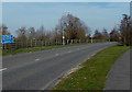
Welcome to Westbury
The A3098 from Dilton Marsh reaches the southern edge of Westbury.
Image: © Jaggery
Taken: 8 Mar 2014
0.06 miles
2

Travellers vans
A view looking southeast to a pair of travellers caravans parked on the grass verge of the new route of the A3098.
Image: © Phil Williams
Taken: 25 Feb 2006
0.07 miles
3
Attractions in Westbury
Viewed across the A3098. The graffiti on the notice has not obscured the attractions listed -
White Horse, historic buildings, swimming pool and sports centre.
Image: © Jaggery
Taken: 8 Mar 2014
0.08 miles
4
![Westbury houses [22]](https://s0.geograph.org.uk/geophotos/06/80/81/6808156_994bcab5_120x120.jpg)
Westbury houses [22]
On Blackhorse Lane, Boyer's House is now two dwellings with Little Boyer's occupying the former offices. An earlier building remodelled in the mid 19th century with a projecting porch. Built in brick, much of it rendered. Listed, grade II, with details at: https://historicengland.org.uk/listing/the-list/list-entry/1036270
Westbury is a former market town in the far west of Wiltshire under the north western edge of Salisbury Plain, 4 miles south of Trowbridge and 4 miles north of Warminster. Westbury was a centre of the cloth industry from the later 15th century until the 19th century. Malting was another important industry. There are now a number of large industrial and trading estates around the town with many residents working there. The town is an important junction point on the railway network with the Reading to Taunton line intersecting the line from Bristol to Southampton.
Westbury Leigh is sometimes considered a separate village, with its own church and chapel, although it is now a contiguous part of the town.
Image: © Michael Dibb
Taken: 9 Feb 2021
0.09 miles
5
![Westbury buildings [10]](https://s3.geograph.org.uk/geophotos/06/80/81/6808159_92c02273_120x120.jpg)
Westbury buildings [10]
It would seem that this site in Ludbourne Place, with its skeleton of a building has been unused and for sale for some considerable time.
Westbury is a former market town in the far west of Wiltshire under the north western edge of Salisbury Plain, 4 miles south of Trowbridge and 4 miles north of Warminster. Westbury was a centre of the cloth industry from the later 15th century until the 19th century. Malting was another important industry. There are now a number of large industrial and trading estates around the town with many residents working there. The town is an important junction point on the railway network with the Reading to Taunton line intersecting the line from Bristol to Southampton.
Westbury Leigh is sometimes considered a separate village, with its own church and chapel, although it is now a contiguous part of the town.
Image: © Michael Dibb
Taken: 9 Feb 2021
0.09 miles
6
![Westbury features [2]](https://s3.geograph.org.uk/geophotos/06/80/81/6808151_ca20daa3_120x120.jpg)
Westbury features [2]
Along Blackhorse Lane is this length of wall which was the garden wall to Boyer's House Image The wall has been restored, lowered, and capped with brick. The garden has been developed for housing. The wall is listed, grade II, with details at: https://historicengland.org.uk/listing/the-list/list-entry/1180341
Blackhorse Lane starts from Westbury Leigh, crosses Suffolk Road and runs to Dartmoor Road where it meets a complex of public footpaths.
Westbury is a former market town in the far west of Wiltshire under the north western edge of Salisbury Plain, 4 miles south of Trowbridge and 4 miles north of Warminster. Westbury was a centre of the cloth industry from the later 15th century until the 19th century. Malting was another important industry. There are now a number of large industrial and trading estates around the town with many residents working there. The town is an important junction point on the railway network with the Reading to Taunton line intersecting the line from Bristol to Southampton.
Westbury Leigh is sometimes considered a separate village, with its own church and chapel, although it is now a contiguous part of the town.
Image: © Michael Dibb
Taken: 9 Feb 2021
0.13 miles
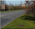
7
![Westbury ways [6]](https://s3.geograph.org.uk/geophotos/06/80/81/6808127_76a9e016_120x120.jpg)
Westbury ways [6]
Blackhorse Lane continues on the other side of Suffolk Road. The lane starts from Westbury Leigh, crosses Suffolk Road and runs to Dartmoor Road where it meets a complex of public footpaths.
Westbury is a former market town in the far west of Wiltshire under the north western edge of Salisbury Plain, 4 miles south of Trowbridge and 4 miles north of Warminster. Westbury was a centre of the cloth industry from the later 15th century until the 19th century. Malting was another important industry. There are now a number of large industrial and trading estates around the town with many residents working there. The town is an important junction point on the railway network with the Reading to Taunton line intersecting the line from Bristol to Southampton.
Westbury Leigh is sometimes considered a separate village, with its own church and chapel, although it is now a contiguous part of the town.
Image: © Michael Dibb
Taken: 9 Feb 2021
0.14 miles
8
White Horse Health Centre, Westbury
The Mane Way health centre opened in September 2012.
Image: © Jaggery
Taken: 8 Mar 2014
0.14 miles
9
![Westbury houses [21]](https://s0.geograph.org.uk/geophotos/06/80/81/6808132_fb12d9a7_120x120.jpg)
Westbury houses [21]
A view of the bland modern housing along Suffolk Road.
Westbury is a former market town in the far west of Wiltshire under the north western edge of Salisbury Plain, 4 miles south of Trowbridge and 4 miles north of Warminster. Westbury was a centre of the cloth industry from the later 15th century until the 19th century. Malting was another important industry. There are now a number of large industrial and trading estates around the town with many residents working there. The town is an important junction point on the railway network with the Reading to Taunton line intersecting the line from Bristol to Southampton.
Westbury Leigh is sometimes considered a separate village, with its own church and chapel, although it is now a contiguous part of the town.
Image: © Michael Dibb
Taken: 9 Feb 2021
0.15 miles
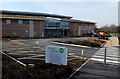
10
![Westbury buildings [11]](https://s0.geograph.org.uk/geophotos/06/80/91/6809136_6ae19086_120x120.jpg)
Westbury buildings [11]
Seen from the car park is the recently built White Horse Health Centre. The centre was very busy with Covid injections.
Westbury is a former market town in the far west of Wiltshire under the north western edge of Salisbury Plain, 4 miles south of Trowbridge and 4 miles north of Warminster. Westbury was a centre of the cloth industry from the later 15th century until the 19th century. Malting was another important industry. There are now a number of large industrial and trading estates around the town with many residents working there. The town is an important junction point on the railway network with the Reading to Taunton line intersecting the line from Bristol to Southampton.
Image: © Michael Dibb
Taken: 9 Feb 2021
0.15 miles