IMAGES TAKEN NEAR TO
Warminster Road, WESTBURY, BA13 3PA
Introduction
This page details the photographs taken nearby to Warminster Road, BA13 3PA by members of the Geograph project.
The Geograph project started in 2005 with the aim of publishing, organising and preserving representative images for every square kilometre of Great Britain, Ireland and the Isle of Man.

There are currently over 7.5m images from over14,400 individuals and you can help contribute to the project by visiting https://www.geograph.org.uk
Image Map (Loading...)


Getting Data...Please wait
Leaflet Map data © OpenStreetMap
Images are licensed for reuse under creativecommons.org/licenses/by-sa/2.0
Notes
- Clicking on the map will re-center to the selected point.
- The higher the marker number, the further away the image location is from the centre of the postcode.
Image Listing (420 Images Found)
Images are licensed for reuse under creativecommons.org/licenses/by-sa/2.0
Image
Details
Distance
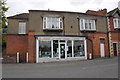
1
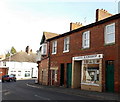
Westbury Lions Bookshop
Located at 7 Warminster Road, Westbury. The sale of donated books here helps finance the work of Westbury Lions, part of Lions Clubs International, the world's largest voluntary service organisation with 1.3 million members serving in over 200 countries. Lions Clubs focus on improving their local communities and supporting worldwide needs such as disaster relief and eradicating disease.
Image: © Jaggery
Taken: 8 Mar 2014
0.01 miles
2
Revival Emporium in Westbury
Second-hand shop at 10 Warminster Road.
Image: © Jaggery
Taken: 8 Mar 2014
0.01 miles
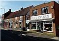
3
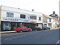
Edward Street, Westbury
Looking northeast up Edward Street, Westbury towards Bratton Road. The premises of F.G. Collier are at the junction of Church street.
Image: © Phil Williams
Taken: 17 Dec 2005
0.01 miles
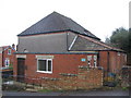
4
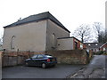
Masonic Hall
A view looking southeast along a lane off Warminster Road, showing the Masonic Hall.
Image: © Phil Williams
Taken: 14 Jan 2006
0.01 miles
5
Masonic Hall
A view looking north across a lane leading off Warminster Road, showing entrance to the Masonic Hall.
Image: © Phil Williams
Taken: 14 Jan 2006
0.01 miles
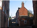
6
Edward Street
A view looking north down Edward Street. The new apartment block on the left has replaced an bakery and shop which formerly occupied this site.
Image: © Phil Williams
Taken: 28 Jan 2006
0.01 miles
7
Springhill
A view looking east up Springhill towards the parking area behind Westfield House.
Image: © Phil Williams
Taken: 28 Jan 2006
0.01 miles
8
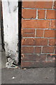
Benchmark on #1 Warminster Road
Ordnance Survey cut mark benchmark described on the Bench Mark Database at http://www.bench-marks.org.uk/bm45369
Image: © Roger Templeman
Taken: 17 Sep 2012
0.01 miles
9
JR Motor Services, #1 Warminster Road
There is an OS benchmark Image on the shop front's left brick column to the right of the white gatepost
Image: © Roger Templeman
Taken: 17 Sep 2012
0.01 miles
10
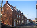
![Westbury buildings [20]](https://s2.geograph.org.uk/geophotos/06/82/85/6828570_907e55b2_120x120.jpg)
Westbury buildings [20]
This range of three properties, numbers 12, 14 and 16 Warminster Road is probably 17th century but may be older - possibly 15th century. Timber framed, refronted in brick, with pebbledash to number 16, under a pantiled roof. All three properties have modern shop fronts. Listed, grade II, with details at: https://historicengland.org.uk/listing/the-list/list-entry/1036314
Westbury is a former market town in the far west of Wiltshire under the north western edge of Salisbury Plain, 4 miles south of Trowbridge and 4 miles north of Warminster. Westbury was a centre of the cloth industry from the later 15th century until the 19th century. Malting was another important industry. There are now a number of large industrial and trading estates around the town with many residents working there. The town is an important junction point on the railway network with the Reading to Taunton line intersecting the line from Bristol to Southampton.
Image: © Michael Dibb
Taken: 29 Apr 2021
0.01 miles