IMAGES TAKEN NEAR TO
Eden Vale Road, WESTBURY, BA13 3NU
Introduction
This page details the photographs taken nearby to Eden Vale Road, BA13 3NU by members of the Geograph project.
The Geograph project started in 2005 with the aim of publishing, organising and preserving representative images for every square kilometre of Great Britain, Ireland and the Isle of Man.

There are currently over 7.5m images from over14,400 individuals and you can help contribute to the project by visiting https://www.geograph.org.uk
Image Map (Loading...)


Getting Data...Please wait
Leaflet Map data © OpenStreetMap
Images are licensed for reuse under creativecommons.org/licenses/by-sa/2.0
Notes
- Clicking on the map will re-center to the selected point.
- The higher the marker number, the further away the image location is from the centre of the postcode.
Image Listing (10 Images Found)
Images are licensed for reuse under creativecommons.org/licenses/by-sa/2.0
Image
Details
Distance
1

Up the Garden Path .....
This sign at the Eastleigh Surgery on Station Road has always amused me. An unintentional comment on the state of the NHS perhaps?
Image: © Phil Williams
Taken: 6 Feb 2006
0.21 miles
2
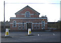
Westbury Methodist Church
Looking southwest across the top of Station Road to the Methodist Church, Westbury
Image: © Phil Williams
Taken: 17 Dec 2005
0.23 miles
3

Eastleigh Surgery, Westbury
Looking northwest along Station Road from its junction with the A350 Haynes Road/West End. The brick buildings at right is part of Eastleigh Surgery.
Image: © Phil Williams
Taken: 17 Dec 2005
0.23 miles
4

St. Bernadettes R.C. Church, Westbury
Looking north across the A350 West End to the R.C. church of St. Bernadette. Eastleigh Surgery is just out of sight at left.
Image: © Phil Williams
Taken: 17 Dec 2005
0.23 miles
5
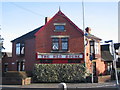
The Red House, Westbury
Looking southeast across the A350 West End at it junction with Station Road and Haynes Road.
Image: © Phil Williams
Taken: 17 Dec 2005
0.23 miles
6
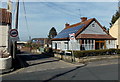
Springfield Road, Westbury
Viewed across the A3098 Leigh Road.
Image: © Jaggery
Taken: 8 Mar 2014
0.23 miles
7
SE end of Eden Vale Road, Westbury
Looking NW from the corner of Leigh Road and Green Lane.
Image: © Jaggery
Taken: 8 Mar 2014
0.24 miles
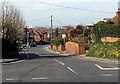
8

2008 : Leigh Road, Westbury
It doesn't look like it but this is the A3098 going south west to Chapmanslade.
Image: © Maurice Pullin
Taken: 8 Jan 2008
0.24 miles
9

Westbury Police Station
Viewed across the B3097 Station Road.
The blue name sign shows Wiltshire Constabulary WESTBURY Police Station.
Image: © Jaggery
Taken: 8 Mar 2014
0.25 miles
10

Westbury Methodist Church
Located at the SE end of the B3097 Station Road, about a kilometre from Westbury railway station.
The church dates from 1925.
Image: © Jaggery
Taken: 8 Mar 2014
0.25 miles