IMAGES TAKEN NEAR TO
The Stables, The Butts, WESTBURY, BA13 3JT
Introduction
This page details the photographs taken nearby to The Stables, The Butts, BA13 3JT by members of the Geograph project.
The Geograph project started in 2005 with the aim of publishing, organising and preserving representative images for every square kilometre of Great Britain, Ireland and the Isle of Man.

There are currently over 7.5m images from over14,400 individuals and you can help contribute to the project by visiting https://www.geograph.org.uk
Image Map (Loading...)


Getting Data...Please wait
Leaflet Map data © OpenStreetMap
Images are licensed for reuse under creativecommons.org/licenses/by-sa/2.0
Notes
- Clicking on the map will re-center to the selected point.
- The higher the marker number, the further away the image location is from the centre of the postcode.
Image Listing (137 Images Found)
Images are licensed for reuse under creativecommons.org/licenses/by-sa/2.0
Image
Details
Distance
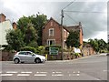
2
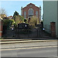
Westbury United Reformed Church
Set back 40 metres from Warminster Road, Westbury.
Image: © Jaggery
Taken: 8 Mar 2014
0.02 miles
3
![Westbury buildings [15]](https://s3.geograph.org.uk/geophotos/06/82/59/6825987_b7d092c8_120x120.jpg)
Westbury buildings [15]
Now, since 1972, the United Reformed Church, this is a former Congregational chapel constructed in 1821 and embellished in the late 19th century. Built in red brick with stone dressings. The gates to the church from Warminster Road, seen at Image, are listed.
Westbury is a former market town in the far west of Wiltshire under the north western edge of Salisbury Plain, 4 miles south of Trowbridge and 4 miles north of Warminster. Westbury was a centre of the cloth industry from the later 15th century until the 19th century. Malting was another important industry. There are now a number of large industrial and trading estates around the town with many residents working there. The town is an important junction point on the railway network with the Reading to Taunton line intersecting the line from Bristol to Southampton.
Image: © Michael Dibb
Taken: 29 Apr 2021
0.02 miles
4
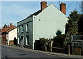
The Old Manse, Westbury
Viewed across Warminster Road.
The gap behind The Old Manse leads to Westbury United Reformed Church. http://www.geograph.org.uk/photo/3882232
Image: © Jaggery
Taken: 8 Mar 2014
0.04 miles
5
![Westbury features [6]](https://s2.geograph.org.uk/geophotos/06/82/59/6825982_bdf5cc00_120x120.jpg)
Westbury features [6]
These fine mid 19th century cast iron gates lead to the United Reformed Church Image Listed, grade II, with details at: https://historicengland.org.uk/listing/the-list/list-entry/1364401
Westbury is a former market town in the far west of Wiltshire under the north western edge of Salisbury Plain, 4 miles south of Trowbridge and 4 miles north of Warminster. Westbury was a centre of the cloth industry from the later 15th century until the 19th century. Malting was another important industry. There are now a number of large industrial and trading estates around the town with many residents working there. The town is an important junction point on the railway network with the Reading to Taunton line intersecting the line from Bristol to Southampton.
Image: © Michael Dibb
Taken: 29 Apr 2021
0.04 miles
6
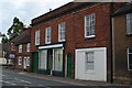
Former shop on Warminster Road, Westbury
The former shopfront is obvious, but it looks as if there may also have been an entrance in the area of the white render.
Image: © David Martin
Taken: 30 Sep 2018
0.05 miles
8
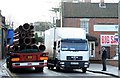
2008 : A350 Warminster Road, Westbury
"The Narrows" cross here at your peril.
One has a certain sympathy for the lorry drivers who have to bring their vehicles through this narrow gap.
The red brick building on the right was until recently The Oak public house.
Image: © Maurice Pullin
Taken: 8 Jan 2008
0.05 miles
9
![Westbury houses [29]](https://s2.geograph.org.uk/geophotos/06/82/59/6825966_a87b5621_120x120.jpg)
Westbury houses [29]
Number 73 Warminster Road is late 18th or early 19th century and was probably originally two cottages, now one. Built in red brick with an old tile roof. Listed, grade II, with details at: https://historicengland.org.uk/listing/the-list/list-entry/1181274
Westbury is a former market town in the far west of Wiltshire under the north western edge of Salisbury Plain, 4 miles south of Trowbridge and 4 miles north of Warminster. Westbury was a centre of the cloth industry from the later 15th century until the 19th century. Malting was another important industry. There are now a number of large industrial and trading estates around the town with many residents working there. The town is an important junction point on the railway network with the Reading to Taunton line intersecting the line from Bristol to Southampton.
Image: © Michael Dibb
Taken: 29 Apr 2021
0.05 miles
10
![Westbury buildings [14]](https://s1.geograph.org.uk/geophotos/06/82/59/6825973_bfd8722f_120x120.jpg)
Westbury buildings [14]
Numbers 75 and 77 Warminster Road occupy an early 19th century building in red brick under a slate roof. The shop front is mid 19th century. The former butchers shop front in the right bay has been removed. Listed, grade II, with details at: https://historicengland.org.uk/listing/the-list/list-entry/1036311
Westbury is a former market town in the far west of Wiltshire under the north western edge of Salisbury Plain, 4 miles south of Trowbridge and 4 miles north of Warminster. Westbury was a centre of the cloth industry from the later 15th century until the 19th century. Malting was another important industry. There are now a number of large industrial and trading estates around the town with many residents working there. The town is an important junction point on the railway network with the Reading to Taunton line intersecting the line from Bristol to Southampton.
Image: © Michael Dibb
Taken: 29 Apr 2021
0.05 miles