IMAGES TAKEN NEAR TO
Haynes Road, WESTBURY, BA13 3HB
Introduction
This page details the photographs taken nearby to Haynes Road, BA13 3HB by members of the Geograph project.
The Geograph project started in 2005 with the aim of publishing, organising and preserving representative images for every square kilometre of Great Britain, Ireland and the Isle of Man.

There are currently over 7.5m images from over14,400 individuals and you can help contribute to the project by visiting https://www.geograph.org.uk
Image Map (Loading...)


Getting Data...Please wait
Leaflet Map data © OpenStreetMap
Images are licensed for reuse under creativecommons.org/licenses/by-sa/2.0
Notes
- Clicking on the map will re-center to the selected point.
- The higher the marker number, the further away the image location is from the centre of the postcode.
Image Listing (462 Images Found)
Images are licensed for reuse under creativecommons.org/licenses/by-sa/2.0
Image
Details
Distance
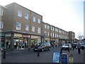
1
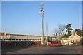
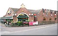
Westbury telephone exchange
Looking north across the car park of Coopers supermarket to the telephone exchange building at Westbury. The new telecoms mast can be seen with the old redundant mast to its right.
Image: © Phil Williams
Taken: 11 Dec 2005
0.02 miles
2
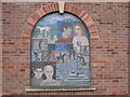
Mosaic at Coopers store
This mosaic on the eastern wall of Coopers store in Edward Street was produced by the pupils of Matravers School to commemorate the links between the youth of Westbury and the Chernobyl area. Young people from the region affected by the Chernobyl explosion still come to Westbury for holiday and respite breaks.
Image: © Phil Williams
Taken: 14 Jan 2006
0.02 miles
3
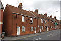
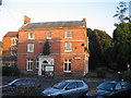
Houses on Haynes Road
There is an OS benchmark Image on the roadside face of the corner of the nearest house
Image: © Roger Templeman
Taken: 17 Sep 2012
0.03 miles
4
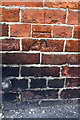
Benchmark on #31 Haynes Road
Ordnance Survey cut mark benchmark described on the Bench Mark Database at http://www.bench-marks.org.uk/bm45368
Image: © Roger Templeman
Taken: 17 Sep 2012
0.03 miles
6
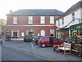
Westbury Library
Looking east to Westbury Library.
Image: © Phil Williams
Taken: 12 Dec 2005
0.04 miles
7
The Garden House Hotel, Westbury
looking west from the tourist information office adjacent to Westbury library to the Garden House Hotel. This building was formerly the town Post Office and has now been given a new lease of life by conversion into a hotel.
Image: © Phil Williams
Taken: 12 Dec 2005
0.04 miles
8

Soissy-sur-Seine Gardens, Westbury
Looking east to Soissy-sur-Seine Gardens, Westbury, named to commemorate a twin town link which has now ended. The white stone at the rear of the green carries a memorial plaque to Diana, Princess of Wales.
Image: © Phil Williams
Taken: 12 Dec 2005
0.04 miles
9
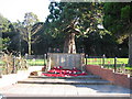
War Memorial, Westbury
Looking east over Edward Street, Westbury, to the war memorial and Soissy-sur-Seine Gardens beyond.
Image: © Phil Williams
Taken: 17 Dec 2005
0.04 miles
10
High Street
A view looking southwest along the High Street.
Image: © Phil Williams
Taken: 21 Jan 2006
0.04 miles