IMAGES TAKEN NEAR TO
Athelney Avenue, WESTBURY, BA13 3GU
Introduction
This page details the photographs taken nearby to Athelney Avenue, BA13 3GU by members of the Geograph project.
The Geograph project started in 2005 with the aim of publishing, organising and preserving representative images for every square kilometre of Great Britain, Ireland and the Isle of Man.

There are currently over 7.5m images from over14,400 individuals and you can help contribute to the project by visiting https://www.geograph.org.uk
Image Map (Loading...)


Getting Data...Please wait
Leaflet Map data © OpenStreetMap
Images are licensed for reuse under creativecommons.org/licenses/by-sa/2.0
Notes
- Clicking on the map will re-center to the selected point.
- The higher the marker number, the further away the image location is from the centre of the postcode.
Image Listing (45 Images Found)
Images are licensed for reuse under creativecommons.org/licenses/by-sa/2.0
Image
Details
Distance
2
![A circular walk from Bratton [71]](https://s0.geograph.org.uk/geophotos/06/48/24/6482492_13e0ab95_120x120.jpg)
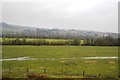
A circular walk from Bratton [71]
Seen from Coach Road are these new houses being built in the triangle of land bounded by Trowbridge Road, Bitham Park and Coach Road. Westbury has grown in recent years with more featureless little boxes being crammed in.
The walk leaves Bratton heading northwest then turns west, circling around the former cement factory to the Old Coach Road on the edge of Westbury. The return is past the Westbury White Horse viewing site on a bridleway and then a track, Lower Westbury Road. About 5¾ miles.
Image: © Michael Dibb
Taken: 21 Apr 2020
0.11 miles
4

Coach Road railway bridge
Yet another of the many railway bridges dotted about Westbury. This one is at the cement works bend entrance of Coach Road.
Image: © Philip Reed
Taken: 22 Jul 2008
0.14 miles
5
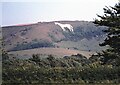
Wiltshire countryside
Bratton Camp White Horse on the hillside.
Image: © Alan Reid
Taken: Unknown
0.16 miles
6
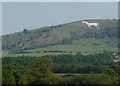
West Wiltshire : Westbury White Horse
The Westbury White Horse on the hillside as seen from a train heading into the town itself.
Image: © Lewis Clarke
Taken: 1 Sep 2011
0.16 miles
7
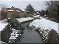
Bitham Brook
A view looking south along Bitham Brook from the top of the culvert taking the stream under The Mead.
Image: © Phil Williams
Taken: 28 Feb 2006
0.18 miles
8
![A circular walk from Bratton [70]](https://s2.geograph.org.uk/geophotos/06/48/24/6482490_8d46ac34_120x120.jpg)
A circular walk from Bratton [70]
Coach Road runs from Trowbridge Road, A350, to Bratton Road, B3098. Motor vehicles are prohibited from most of the route. On OS maps the road is shown as 'other route with public access'.
The walk leaves Bratton heading northwest then turns west, circling around the former cement factory to the Old Coach Road on the edge of Westbury. The return is past the Westbury White Horse viewing site on a bridleway and then a track, Lower Westbury Road. About 5¾ miles.
Image: © Michael Dibb
Taken: 21 Apr 2020
0.18 miles
9
![A circular walk from Bratton [69]](https://s1.geograph.org.uk/geophotos/06/48/24/6482489_7844db55_120x120.jpg)
A circular walk from Bratton [69]
This un-named road leaving Coach Road leads to White Horse Country Park, Westbury Golf Club, Westbury Rugby Club and a camp site. Coach Road is closed to all traffic beyond this point.
The walk leaves Bratton heading northwest then turns west, circling around the former cement factory to the Old Coach Road on the edge of Westbury. The return is past the Westbury White Horse viewing site on a bridleway and then a track, Lower Westbury Road. About 5¾ miles.
Image: © Michael Dibb
Taken: 21 Apr 2020
0.18 miles
10
![A circular walk from Bratton [74]](https://s2.geograph.org.uk/geophotos/06/48/24/6482498_099f7d96_120x120.jpg)
A circular walk from Bratton [74]
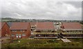
Seen from Coach Road are these new houses being built in the triangle of land bounded by Trowbridge Road, Bitham Park and Coach Road. Westbury has grown in recent years with more featureless little boxes being crammed in.
The walk leaves Bratton heading northwest then turns west, circling around the former cement factory to the Old Coach Road on the edge of Westbury. The return is past the Westbury White Horse viewing site on a bridleway and then a track, Lower Westbury Road. About 5¾ miles.
Image: © Michael Dibb
Taken: 21 Apr 2020
0.18 miles