IMAGES TAKEN NEAR TO
WESTBURY, BA13 3GJ
Introduction
This page details the photographs taken nearby to BA13 3GJ by members of the Geograph project.
The Geograph project started in 2005 with the aim of publishing, organising and preserving representative images for every square kilometre of Great Britain, Ireland and the Isle of Man.

There are currently over 7.5m images from over14,400 individuals and you can help contribute to the project by visiting https://www.geograph.org.uk
Image Map (Loading...)


Getting Data...Please wait
Leaflet Map data © OpenStreetMap
Images are licensed for reuse under creativecommons.org/licenses/by-sa/2.0
Notes
- Clicking on the map will re-center to the selected point.
- The higher the marker number, the further away the image location is from the centre of the postcode.
Image Listing (480 Images Found)
Images are licensed for reuse under creativecommons.org/licenses/by-sa/2.0
Image
Details
Distance
1
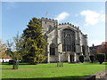
All Saints Church
The unusual west front
Image: © Kevin Farmer
Taken: 18 Oct 2009
0.01 miles
4
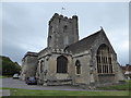
All Saints, Westbury: Mid August 2016
Also see https://www.achurchnearyou.com/westbury-all-saints/
Image: © Basher Eyre
Taken: 22 Aug 2016
0.02 miles
5
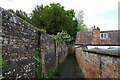
![Westbury houses [84]](https://s0.geograph.org.uk/geophotos/06/83/99/6839972_84413a6f_120x120.jpg)
Westbury houses [84]
Church View, in Churchyard is 17th or early 18th century. Built of stuccoed brick with an old tile roof. Listed, grade II, with details at: https://historicengland.org.uk/listing/the-list/list-entry/1036288
Westbury is a former market town in the far west of Wiltshire under the north western edge of Salisbury Plain, 4 miles south of Trowbridge and 4 miles north of Warminster. Westbury was a centre of the cloth industry from the later 15th century until the 19th century. Malting was another important industry. There are now a number of large industrial and trading estates around the town with many residents working there. The town is an important junction point on the railway network with the Reading to Taunton line intersecting the line from Bristol to Southampton.
Image: © Michael Dibb
Taken: 29 Apr 2021
0.03 miles
7
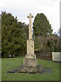
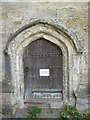
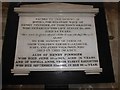
All Saints' memorial
In the grounds of the main church in the town is a small but important war memorial. The town has had more than one, including the Market Square version which was removed for road widening in the 1970s.
The inscription recalls the men of Westbury who lost their lives in the Great War.
Image: © Neil Owen
Taken: 26 Feb 2014
0.03 miles
8

War Memorial, Westbury
Erected c1920 in the SE corner of All Saints churchyard.
Image: © Jaggery
Taken: 8 Mar 2014
0.03 miles
9
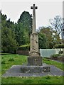
War memorial
Westbury war memorial, in the churchyard is a tall, notched cross. Erected in 1919 or 1920. Listed, grade II, with details at: https://historicengland.org.uk/listing/the-list/list-entry/1364427
Westbury is a former market town in the far west of Wiltshire under the north western edge of Salisbury Plain, 4 miles south of Trowbridge and 4 miles north of Warminster. Westbury was a centre of the cloth industry from the later 15th century until the 19th century. Malting was another important industry. There are now a number of large industrial and trading estates around the town with many residents working there. The town is an important junction point on the railway network with the Reading to Taunton line intersecting the line from Bristol to Southampton.
Image: © Michael Dibb
Taken: 29 Apr 2021
0.03 miles
10
![Westbury houses [85]](https://s0.geograph.org.uk/geophotos/06/83/99/6839976_4a29ffa3_120x120.jpg)
Westbury houses [85]
Originally three cottages now two, Brookhaven, number 1 Churchyard, and number 1A Churchyard are 18th century. Built of brick on a stone plinth under an old tile roof. Listed, grade II, with details at: https://historicengland.org.uk/listing/the-list/list-entry/1180620
Westbury is a former market town in the far west of Wiltshire under the north western edge of Salisbury Plain, 4 miles south of Trowbridge and 4 miles north of Warminster. Westbury was a centre of the cloth industry from the later 15th century until the 19th century. Malting was another important industry. There are now a number of large industrial and trading estates around the town with many residents working there. The town is an important junction point on the railway network with the Reading to Taunton line intersecting the line from Bristol to Southampton.
Image: © Michael Dibb
Taken: 29 Apr 2021
0.03 miles