IMAGES TAKEN NEAR TO
The Paddocks, WESTBURY, BA13 3FY
Introduction
This page details the photographs taken nearby to The Paddocks, BA13 3FY by members of the Geograph project.
The Geograph project started in 2005 with the aim of publishing, organising and preserving representative images for every square kilometre of Great Britain, Ireland and the Isle of Man.

There are currently over 7.5m images from over14,400 individuals and you can help contribute to the project by visiting https://www.geograph.org.uk
Image Map (Loading...)


Getting Data...Please wait
Leaflet Map data © OpenStreetMap
Images are licensed for reuse under creativecommons.org/licenses/by-sa/2.0
Notes
- Clicking on the map will re-center to the selected point.
- The higher the marker number, the further away the image location is from the centre of the postcode.
Image Listing (219 Images Found)
Images are licensed for reuse under creativecommons.org/licenses/by-sa/2.0
Image
Details
Distance
1
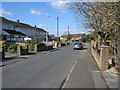
Frogmore Road
A view looking north along Frogmore Road to the junction with Sarum Gardens (right).
Image: © Phil Williams
Taken: 25 Feb 2006
0.03 miles
2
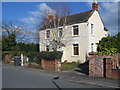
Elm View
A view looking northeast across Frogmore Road to the dwelling of Elm View.
Image: © Phil Williams
Taken: 25 Feb 2006
0.04 miles
3
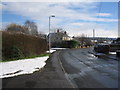
Frogmore Road
A view looking southeast along Frogmore Road towards the junction with Sarum Gardens (left) after a light snowfall.
Image: © Phil Williams
Taken: 28 Feb 2006
0.06 miles
4
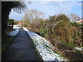
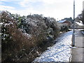
Footpath alongside Bitham Brook
A view looking north along the footpath from Frogmore road to The Mead. Butham Brook is on the right.
Image: © Phil Williams
Taken: 28 Feb 2006
0.06 miles
5
Footpath alongside Bitham Brook.
A view looking south back to Frogmore Road. Bitham Brook is on the left.
Image: © Phil Williams
Taken: 28 Feb 2006
0.06 miles
6
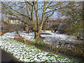
Bitham Brook
A view looking northeast to Bitham Brook from the footpath between Frogmore Road and The Mead, following a recent light snowfall.
Image: © Phil Williams
Taken: 28 Feb 2006
0.06 miles
7
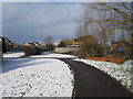
Footpath to The Mead
A view taken after a recent light snowfall, looking north along the footpath leading from Frogmore Road to The Mead. A culvert over Bitham Brook can be seen at right.
Image: © Phil Williams
Taken: 28 Feb 2006
0.06 miles
8
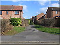
Footpath to Wiltshire Way
A view looking northeast across Frogmore Road to the footpath leading to Wiltshire Way.
Image: © Phil Williams
Taken: 25 Feb 2006
0.08 miles
9
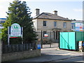
Frogmore House
After many years as the offices of a cosmetics manufacturing facility, Frogmore House is being converted into residential accommodation. Development is currently stalled due to planning issues.
Image: © Phil Williams
Taken: 25 Feb 2006
0.08 miles
10
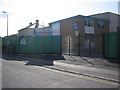
Frogmore House
A view looking southwest to the manufacturing facility attached to Frogmore House.
Image: © Phil Williams
Taken: 25 Feb 2006
0.08 miles