IMAGES TAKEN NEAR TO
Gilhespy Way, WESTBURY, BA13 3FT
Introduction
This page details the photographs taken nearby to Gilhespy Way, BA13 3FT by members of the Geograph project.
The Geograph project started in 2005 with the aim of publishing, organising and preserving representative images for every square kilometre of Great Britain, Ireland and the Isle of Man.

There are currently over 7.5m images from over14,400 individuals and you can help contribute to the project by visiting https://www.geograph.org.uk
Image Map (Loading...)


Getting Data...Please wait
Leaflet Map data © OpenStreetMap
Images are licensed for reuse under creativecommons.org/licenses/by-sa/2.0
Notes
- Clicking on the map will re-center to the selected point.
- The higher the marker number, the further away the image location is from the centre of the postcode.
Image Listing (46 Images Found)
Images are licensed for reuse under creativecommons.org/licenses/by-sa/2.0
Image
Details
Distance
1
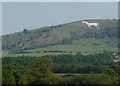
West Wiltshire : Westbury White Horse
The Westbury White Horse on the hillside as seen from a train heading into the town itself.
Image: © Lewis Clarke
Taken: 1 Sep 2011
0.11 miles
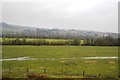
3
The Mead
A view looking northeast across The Meadfrom the footpath from frogmore Road, The Lafarge cement works chimney can be seen at left, with the shape of the Westbury White Horse appearing dark against the recent snowfall to the right of the tree.
Image: © Phil Williams
Taken: 28 Feb 2006
0.12 miles
4
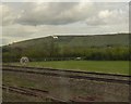
Approaching Heywood Road Junction, heading west, with the Westbury White Horse in the background
Image: © Rob Purvis
Taken: 30 Apr 2016
0.15 miles
5
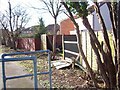
Storm-damaged fences at Gloucester Walk
Looking south along the back of houses at Gloucester Walk, off The Mead, Westbury
Image: © Philip Reed
Taken: 25 Jan 2007
0.16 miles
6
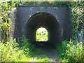
Railway bridge, Church Path, Westbury
Taken from between both bridges, this one holds the Westbury Station bypass track allowing high speed trains to take a shorter route around the edge of Westbury and avoid the station.
Image: © Philip Reed
Taken: 24 Jul 2008
0.16 miles
7
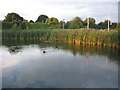
Coots on the Mead pond
A view looking to the north towards coots on one of the ponds off The Mead. These were created as part of the flood prevention measures associated with a new housing development and form part of a nature reserve. The white pipes on the right are quite flimsy and I assume are ventilation for the landfill used on the site.
Image: © Phil Williams
Taken: 18 Sep 2007
0.16 miles
9
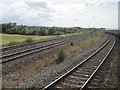
Heywood Road Junction
The two lines to the right are for Westbury, the two to the left are the Westbury avoiding lines.
Image: © Nigel Thompson
Taken: 27 Jun 2015
0.17 miles
10
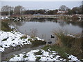
Coots on the Mead pond
A view looking northwest over the Mead pond, following a recent light snowfall.
Image: © Phil Williams
Taken: 28 Feb 2006
0.17 miles